
Coppicing is the traditional method in woodland management of cutting down a tree to a stump, which in many species encourages new shoots to grow from the stump or roots, thus ultimately regrowing the tree. A forest or grove that has been subject to coppicing is called a copse or coppice, in which young tree stems are repeatedly cut down to near ground level. The resulting living stumps are called stools. New growth emerges, and after a number of years, the coppiced trees are harvested, and the cycle begins anew. Pollarding is a similar process carried out at a higher level on the tree in order to prevent grazing animals from eating new shoots. Daisugi, is a similar Japanese technique.

Hyacinthoides non-scripta is a bulbous perennial plant, found in Atlantic areas from north-western Spain to the British Isles, and also frequently used as a garden plant. It is known in English as the common bluebell or simply bluebell, a name which is used in Scotland to refer to the harebell, Campanula rotundifolia. In spring, H. non-scripta produces a nodding, one-sided inflorescence of 5–12 tubular, sweet-scented violet–blue flowers, with strongly recurved tepals, and 3–6 long, linear, basal leaves.

A savanna or savannah is a mixed woodland-grassland ecosystem characterised by the trees being sufficiently widely spaced so that the canopy does not close. The open canopy allows sufficient light to reach the ground to support an unbroken herbaceous layer consisting primarily of grasses. According to Britannica, there exists four savanna forms; savanna woodland where trees and shrubs form a light canopy, tree savanna with scattered trees and shrubs, shrub savanna with distributed shrubs, and grass savanna where trees and shrubs are mostly nonexistent.

The Eurasian treecreeper or common treecreeper is a small passerine bird also known in the British Isles, where it is the only living member of its genus, simply as treecreeper. It is similar to other treecreepers, and has a curved bill, patterned brown upperparts, whitish underparts, and long stiff tail feathers which help it creep up tree trunks. It can be most easily distinguished from the similar short-toed treecreeper, which shares much of its European range, by its different song.

Woodland Park is a 90.9-acre (36.8 ha) public park in Seattle's Phinney Ridge and Green Lake neighborhoods that originated as the estate of Guy C. Phinney, lumber mill owner and real estate developer. Phinney died in 1893, and in 1902, the Olmsted Brothers firm of Boston was hired to design the city's parks, including Woodland Park.
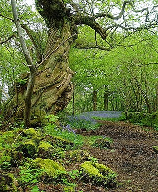
In the United Kingdom, ancient woodland is that which has existed continuously since 1600 in England, Wales and Northern Ireland. Planting of woodland was uncommon before those dates, so a wood present in 1600 is likely to have developed naturally.

Bookham Commons are two commons, situated just to the north of the villages of Great Bookham and Little Bookham, in Surrey, England, 154.7 hectares in extent; the individual parts are named Great Bookham Common and Little Bookham Common. A group of dwellings known as the Isle of Wight is situated within the site, and a track, Common Road, leads to it from the northwest. Little Bookham Common lies south and west of this track, whereas Great Bookham Common lies to the east.

Aylesbeare is a village and civil parish in the East Devon district of Devon, England, 8 miles (13 km) east of Exeter. According to the 2001 census the parish, which includes the hamlet of Nutwalls, had a population of 527. Known for the Site of Special Scientific Interest on Aylesbeare Common that is managed by the Royal Society for the Protection of Birds, Aylesbeare was in the news during 1978 as the scene of the unresolved disappearance of the schoolgirl Genette Tate.

Camley Street Natural Park is an urban nature reserve in St Pancras in central London and within the London Borough of Camden. It is a local nature reserve.

California oak woodland is a plant community found throughout the California chaparral and woodlands ecoregion of California in the United States and northwestern Baja California in Mexico. Oak woodland is widespread at lower elevations in coastal California; in interior valleys of the Coast Ranges, Transverse Ranges and Peninsular Ranges; and in a ring around the California Central Valley grasslands. The dominant trees are oaks, interspersed with other broadleaf and coniferous trees, with an understory of grasses, herbs, geophytes, and California native plants.

The Cumberland Plain, also known as Cumberland Basin, is a relatively flat region lying to the west of Sydney CBD in New South Wales, Australia. An IBRA biogeographic region, Cumberland Basin is the preferred physiographic and geological term for the low-lying plain of the Permian-Triassic Sydney Basin found between Sydney and the Blue Mountains, and it is a structural sub-basin of the Sydney Basin.

The inland broad-nosed bat is a species of vesper bat. They are endemic to Australia and widespread throughout the inland, especially in arid and semi-arid regions. This insectivorous microbat, measuring 12 centimetres (4.7 in) in length, roosts in tree hollows during the day and forages over woodland and water at night.
Lowland heath is a Biodiversity Action Plan habitat as it is a type of ancient wild landscape. Natural England's Environmental Stewardship scheme describes lowland heath as containing dry heath, wet heath and valley mire communities, usually below 250 metres (820 ft) in altitude, on acidic soils and shallow peat, typically comprising heathers, gorses, fine grasses, wild flowers and lichens in a complex mosaic. Heathers and other dwarf shrubs usually account for at least 25% of the ground cover. By contrast, upland heath, which is above 300 metres (980 ft) in altitude, is called moorland, Dartmoor being an example.

The Turnford and Cheshunt Pits is a biological Site of Special Scientific Interest near Cheshunt in Hertfordshire and Essex and covers a total of 428.17 acres. It is part of the Lee Valley Special Protection Area.
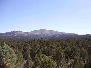
Pinyon–juniper woodland, also spelled piñon–juniper woodland, is a biome found mid-elevations in arid regions of the Western United States, characterized by being an open forest dominated by low, bushy, evergreen junipers, pinyon pines, and their associates. At lower elevations, junipers often predominate and trees are spaced widely, bordering on and mingling with grassland or shrubland, but as elevation increases, pinyon pines become common and trees grow closer, forming denser canopies. Historically, pinyon-juniper woodland has provided a vital source of fuel and food for peoples of the American Southwest.

Titnore Wood is an area of ancient woodland to the north-west of Worthing in West Sussex. With neighbouring Goring Wood it forms one of the last remaining blocks of ancient woodland on the West Sussex coastal plain.

Mediterranean scrub is a biome defined by the World Wide Fund for Nature. The biome is generally characterized by dry summers and rainy winters, although in some areas rainfall may be uniform. Summers are typically hot in low-lying inland locations but can be cool near colder seas. Winters are typically mild to cool in low-lying locations but can be cold in inland and higher locations. All these ecoregions are highly distinctive, collectively harboring 10% of the Earth's plant species.

The Aylesbeare Mudstone Group is an early Triassic lithostratigraphic group in southwest England. The name is derived from the village of Aylesbeare in east Devon. The Group comprises the Littleham Mudstone Formation, the Exmouth Mudstone and Sandstone Formation and the underlying Clyst St Lawrence Formation. The strata are exposed on the coast between Exmouth and Budleigh Salterton where the type section is defined. The rocks of the Aylesbeare Mudstone Group have also previously been known as the Aylesbeare Group and the Aylesbeare Mudstone Formation.
Wolseley Common Conservation Park is a protected area located in the Australian state of South Australia in the locality of Wolseley about 260 kilometres (160 mi) south-east of the state capital of Adelaide, about 13 kilometres (8.1 mi) south-east of the town of Bordertown and immediately adjoining the south-west side of the town of Wolseley.

Newton Poppleford and Harpford is a civil parish in East Devon, England. It is surrounded clockwise from the north by the parishes of Ottery St Mary, Sidmouth, Otterton, Colaton Raleigh and Aylesbeare. The parish includes the large village of Newton Poppleford, and also includes the smaller settlements of Harpford, Burrow, Southerton and Venn Ottery. As of 2019, it has a population of 2,153.

