Bariqa

Last updated
Bariqa
بريقة
Village
Buraykah

Bareeqa V Golanhights.JPG

View of Bariqa, 2007
Golan location map 2.PNG
Red pog.svg
Bariqa
Syria adm location map.svg
Red pog.svg
Bariqa
Coordinates: 33°02′35″N35°52′16″E / 33.04306°N 35.87111°E / 33.04306; 35.87111 Coordinates: 33°02′35″N35°52′16″E / 33.04306°N 35.87111°E / 33.04306; 35.87111
CountryFlag of Syria.svg  Syria
Governorate Quneitra
District Quneitra
Subdistrict Quneitra
Population (2004)
  Total 371
  Religions Sunni Muslim
Time zone EET (UTC+2)
  Summer (DST) EEST (UTC+3)
Area code(s) 14

Bariqa (Arabic : بريقة, also spelled Buraykah or Breikeh) is a village in southwestern Syria, administratively part of the Quneitra Governorate, south of Quneitra, in the Syrian-controlled portion of the Golan Heights. Nearby localities include Beer Ajam to the north, Naba al-Sakhr to the northeast, al-Harra and Namer to the east, al-Suwaysah and Jasim to the southeast and al-Rafid to the south. According to the Syria Central Bureau of Statistics (CBS), Bariqa had a population of 371 in the 2004 census. [1] Its inhabitants are predominantly Circassians from the Abadzekh tribe, [2] who profess Sunni Islam.

Syria Country in Western Asia

Syria, officially the Syrian Arab Republic, is a country in Western Asia, bordering Lebanon to the southwest, the Mediterranean Sea to the west, Turkey to the north, Iraq to the east, Jordan to the south, and Israel to the southwest. A country of fertile plains, high mountains, and deserts, Syria is home to diverse ethnic and religious groups, including Syrian Arabs, Greeks, Armenians, Assyrians, Kurds, Circassians, Mandeans and Turks. Religious groups include Sunnis, Christians, Alawites, Druze, Isma'ilis, Mandeans, Shiites, Salafis, Yazidis, and Jews. Sunni make up the largest religious group in Syria.

Quneitra Governorate Governorate in Syria

Quneitra Governorate is one of the fourteen governorates (provinces) of Syria. It is situated in southern Syria, notable for the location of the Golan Heights. The governorate borders the countries of Lebanon, Jordan and Israel, and the Syrian governorates of Daraa and Rif Dimashq. Its area varies, according to different sources, from 685 km² to 1,861 km². The governorate had a population of 87,000 at the 2010 estimate. The nominal capital is the now abandoned city of Quneitra, destroyed by Israel before their withdrawal in June 1974 in the aftermath of the Yom Kippur War; since 1986, the de facto capital is Ba'ath City.

Golan Heights Place in Internationally recognized as Syrian territory occupied by Israel

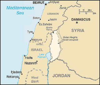
The Golan Heights, or simply the Golan, is a region in the Levant, spanning about 1,800 square kilometres (690 sq mi). The region defined as the Golan Heights differs between disciplines: as a geological and biogeographical region, the Golan Heights is a basaltic plateau bordered by the Yarmouk River in the south, the Sea of Galilee and Hula Valley in the west, the Anti-Lebanon with Mount Hermon in the north and Wadi Raqqad in the east; and as a geopolitical region, the Golan Heights is the area captured from Syria and occupied by Israel during the Six-Day War, territory which Israel effectively annexed in 1981. This region includes the western two-thirds of the geological Golan Heights, as well as the Israeli-occupied part of Mount Hermon.

In the late 19th-century Bariqa was described as "one of the largest and best of the Circassian villages." It consisted of about 100 houses with 85 families, translating into an approximate population of 425, including 68 adult male fighters. Its streets were wide and clean, it abounded in heaps of hay and contained a well-built mosque. To the north of Bariqa was an icy-water spring and to the east was a pool which irrigated the village's crops. Bariqa served as the residence of the sheikh ("chief") of all the Circassian villages in the Golan Heights region. [3]

Mosque Place of worship for followers of Islam

A mosque is a place of worship for Muslims.

Sheikh —also transliterated Sheik, Shykh, Shayk, Shaykh, Cheikh, Shekh, and Shaikh—is an honorific title in the Arabic language. It commonly designates the ruler of a tribe, who inherited the title from his father. "Sheikh" is given to a royal male at birth and the related title "Sheikha" is given to a royal female at birth.

Opposition rebels and Syrian Army soldiers clashed in Bariqa and nearby Beer Ajam in November 2012, during the ongoing Syrian civil war, which began in 2011. Fatalities on both sides totaled about 30, according to a monitoring group. [4] The village was reported to be under rebel control by 13 November. [5] On 26 July 2018, the Syrian army take back the town after rebels surrender and handing over the heavy and medium weapons to army. [6]

Syrian Army land force branch of the Syrian Armed Forces

The Syrian Army, officially the Syrian Arab Army (SAA), is the land force branch of the Syrian Armed Forces. It is the dominant military service of the four uniformed services, controlling the most senior posts in the armed forces, and has the greatest manpower, approximately 80 percent of the combined services. The Syrian Army originated in local military forces formed by the French after World War I, after France obtained a mandate over the region. It officially came into being in 1945, before Syria obtained full independence the following year.

Related Research Articles

Beer Ajam Village in Quneitra, Syria

Beer Ajam is a Syrian Circassian village in the Quneitra Governorate in the Syrian controlled portion of the Golan Heights. It has been inhabited for about 150 years. Its first houses were built in 1872. Nearby localities include Quneitra to the north, Naba al-Sakhr to the northeast, al-Harra to the east, Namer to the southeast and Bariqa to the south. According to the Syria Central Bureau of Statistics (CBS), Beer Ajam had a population of 353 in the 2004 census. Its inhabitants are Circassians from the Abadzekh and Kebertei tribes.

Kafr Shams Village in Daraa, Syria

Kafr Shams is a small city in southern Syria administratively belonging to the Al-Sanamayn District of the Daraa Governorate. It is 16 kilometers (9.9 mi) northwest of al-Sanamayn, just east of the Golan Heights and situated between Damascus and Daraa. In the 2004 census by the Central Bureau of Statistics Kafr Shams had a population of 12,435.

Al-Harra, Syria Town in Daraa, Syria

Al-Harra, also spelled Khirbet al-Harra; translation: "the Hot") is a town in southern Syria, administratively belonging to the al-Sanamayn District of the Daraa Governorate. Situated in the Hauran plain, it is 55 kilometers (34 mi) north of Daraa, and just east of Bir Ajam and the Golan Heights, northwest of Jasim, west of al-Sanamayn and southwest of Kafr Shams. In the 2004 census by the Central Bureau of Statistics, al-Harra had a population of 17,172.

Beit Jinn Town in Rif Dimashq Governorate, Syria

Beit Jinn, also known as Bayt Jin, Beit Jann or Beyt Jene, is a town in southern Syria, administratively part of the Rif Dimashq Governorate, located southwest of Damascus on the foothills of Mount Hermon. According to the Syria Central Bureau of Statistics, Beit Jinn had a population of 2,846 in the 2004 census. Its inhabitants are predominantly Sunni Muslims.

Maar Shamshah Village in Idlib, Syria

Maar Shamshah is a village administratively belonging to the Idlib Governorate in northwestern Syria. Nearby localities include the mantiqah ("district") center of Maarrat al-Nu'man to the west, Maar Shurin to the north, Talmenes to the east, Maar Shamrin and Deir Sharqi to the southeast and Deir Gharbi to the south. According to the Syria Central Bureau of Statistics, Maar Shamshah had a population of 3,268 in the 2004 census.

Quneitra Governorate clashes (2012–14) conflict starting in November 2012

The 2012–14 Quneitra Governorate clashes began in early November 2012, when the Syrian Army began engaging with rebels in several towns and villages of the Quneitra Governorate. The clashes quickly intensified and spilled into the UN-supervised neutral demilitarized zone between Syrian controlled territory and the Israeli-occupied Golan Heights.

Kanaker, Syria Village in Rif Dimashq Governorate, Syria

Kanaker is a village in southern Syria, administratively part of the Rif Dimashq Governorate, located southwest of Damascus. Nearby localities include Sa'sa' to the west, Beit Saber to the northwest, Khan al-Shih to the north, Zakiyah, al-Taybah, Khan Dannun and al-Kiswah to the northeast, Deir Ali and Jubb al-Safa to the east, Ghabaghib to the southeast, Kafr Nasej and Deir al-Adas to the south and Jabah to the southwest. According to the Syria Central Bureau of Statistics, Kanaker had a population of 13,950 in the 2004 census, making it the largest locality in the nahiyah ("subdistrict") of Saasaa. Kanaker marks the western boundary of the Marj al-Suffar plain.

Ayn al-Niser Village in Homs, Syria

Ayn al-Niser is a town in central Syria, administratively part of the Homs Governorate, located northeast of Homs. Nearby localities include al-Mishirfeh to the west, Ayn al-Dananir to the northwest, Izz al-Din to the north, al-Mukharram al-Fawqani to the east and Umm al-Amad to the southeast.

Jamla Village in Daraa, Syria

Jamla is a village in southwestern Syria, administratively part of the Daraa Governorate and immediately east of the Israeli-occupied Golan Heights. It is situated on the eastern slopes of the Wadi Ruqqad valley. Nearby localities include Abdin to the south, the nahiyah ("subdistrict") center of al-Shajara to the southwest, Nafia to the east, Ayn Zakar to the northeast and Saida to the north. According to the Syria Central Bureau of Statistics (CBS), Jamla had a population of 1,916 in the 2004 census. Its inhabitants are predominantly Sunni Muslims.

Sasa, Syria Town in Rif Dimashq Governorate, Syria

Sa'sa' is a town in southern Syria, administratively part of the Rif Dimashq Governorate, located southwest of Damascus near the Golan Heights. Nearby localities include Kafr Hawr to the north, Kanaker to the east, Khan Arnabah to the southwest, and Deir Maker to the south. According to the Syria Central Bureau of Statistics, Sa'sa' had a population of 9,945 in the 2004 census. The town is also the administrative centre of—though not the largest town in—the Sa'sa' nahiyah, which is made up of 17 towns having a combined population of 45,233.

Khan Arnabah Town in Quneitra, Syria

Khan Arnabah is a town in southern Syria, administratively part of the Quneitra Governorate, in the portion of the province still under Syrian control. The town is located just outside the United Nations Disengagement Observer Force Zone. Nearby localities include Sa'sa' to the northeast, Quneitra to the southwest, Jubata al-Khashab to the northwest, as well as the Circassian villages of Beer Ajam and Bariqa to the south. According to the Syria Central Bureau of Statistics, Khan Arnabah had a population of 7,375 in the 2004 census. The town is also the administrative centre of the Khan Arnabah nahiyah, which is made up of 19 towns having a combined population of 42,980.

The Circassians in Syria refers to the Circassian diaspora, some of whom settled in Syria in the 19th century. They moved to Syria after a forced migration to the Ottoman Empire resulting from a Russian invasion in the early 1860s. Most pre-Civil War estimates put the Circassian population at around 100,000. They are predominantly Sunni Muslims. While they have become an increasingly assimilated part of Syrian society, they have maintained a distinct identity, having retained their Adyghe language, their tribal heritage and some of their traditional customs. Syria's Circassian population has dwindled with the advent of the civil war that has been ongoing in Syria since 2011.

Marj al-Sultan Village in Rif Dimashq, Syria

Marj al-Sultan is a village in southern Syria, administratively part of the Rif Dimashq Governorate, located 15 kilometers east of Damascus city. The village is situated in the fertile Ghouta region amid an orchard-filled area. Nearby localities include Harasta al-Qantarah and Zabdin to the west, al-Nashabiyah to the north, al-Bilaliyah to the east, Deir Salman to the southeast, Sakka to the south and Deir al-Asafir to the southwest.

Maan, Syria Town in Hama, Syria

Ma'an is a town in northern Syria, administratively part of the Hama Governorate, located north of Hama. Nearby localities include Suran to the southwest, Murik to the northwest, al-Tamaanah to the north, Atshan to the northeast, Tuleisa to the east, Fan al-Shamali to the southeast and Kawkab to the south. According to the Syria Central Bureau of Statistics, Ma'an had a population of 1,561 in the 2004 census. Its inhabitants are predominantly Alawites.

Hader, Quneitra Governorate Town in Quneitra, Syria

Hader is a village in southern Syria, administratively part of the Khan Arnabah Subdistrict of the Quneitra Governorate. It is in the portion of the governorate that is still under Syrian, rather than Israeli, control. The town is located just outside the United Nations Disengagement Observer Force Zone. Nearby localities include Beit Jinn to the northeast, Harfa to the east, Jubata al-Khashab to the south, Majdal Shams in the Israeli Golan Heights to the west and Shebaa in Lebanon to the northwest.

Al-Rafid, Syria Town in Quneitra, Syria

Al-Rafid is a village in southern Syria, administratively part of the Quneitra Governorate, in the portion of the province under the United Nations Disengagement Observer Force Zone. According to the Syria Central Bureau of Statistics, al-Rafid had a population of 2,263 in the 2004 census.

Jubata al-Khashab Town in Quneitra, Syria

Jubata al-Khashab is a town in southern Syria, administratively part of the Quneitra Governorate, in the portion of the province under the United Nations Disengagement Observer Force Zone. According to the Syria Central Bureau of Statistics, Jubata al-Khashab had a population of 3,493 in the 2004 census. Its inhabitants are predominantly Sunni Muslims, although the population has decreased drastically due to the exodus of residents fleeing the violence of the Syrian Civil War. On 13 September 2015, army units killed and injured a number of militants and destroyed many of their hideouts in direct strikes targeting their gatherings in the village.

Golan Regiment

The Golan Regiment is a Syrian militia based in Khan Arnabah that is part of the National Defence Forces (NDF). Though primarily active in the Golan Heights, the unit has been deployed in various warzones of western Syria, fighting against many different Syrian opposition forces and the Islamic State of Iraq and the Levant. The Golan Regiment is notable insofar as it was the first government unit during the Syrian Civil War that was founded by Free Syrian Army (FSA) defectors.

Jamaat Jund al-Qawqaz

Jamaat Jund al-Qawqaz, also known as Ahrar al-Sharkas, is an armed group based in the Quneitra Governorate of Syria with some fighters in the Latakia Governorate. The group is made up of ethnic Circassians from Beer Ajam. The group came to prominence during the Quneitra Governorate clashes (2012–14).

References

  1. General Census of Population and Housing 2004 Archived 2013-01-22 at the Wayback Machine .. Syria Central Bureau of Statistics (CBS). Quneitra Governorate. (in Arabic)
  2. Jaimoukha, Amjad. The Circassians of Syria: Opting for the Rightful Cause Circassian Voices. 2012-07-12.
  3. Schumacher, 1888, pp. 113-114.
  4. AAP (10 November 2012). "More than 30 Syrians killed in Golan". PerthNow. The Sunday Times (Western Australia). Retrieved 27 November 2012.
  5. Greenwood, Phoebe; Sherlock, Ruth; McElroy, Damien (13 November 2012). "Syrian rebels seize territory north of Golan Heights". London: The Daily Telegraph (Australia). Retrieved 27 November 2012.
  6. After days of negotiations, an agreement and settlements were reached in towns in the northern countryside of Quneitra

Bibliography