Barry's Bay

Last updated

Barry's Bay
Unincorporated community
Barrys Bay Ontario.JPG
Barry's Bay visitor centre and former train station
Canada Southern Ontario location map 2.png
Red pog.svg
Barry's Bay
Coordinates: 45°29′18″N77°40′44″W / 45.48833°N 77.67889°W / 45.48833; -77.67889
CountryFlag of Canada (Pantone).svg Canada
ProvinceFlag of Ontario.svg  Ontario
County Renfrew
Township municipality Madawaska Valley
Incorporated1933
Amalgamated2001
Government
  TypeUnincorporated
Population
 (2016)
  Total1,259
Time zone UTC-5 (Eastern Time Zone)
  Summer (DST) UTC-4 (Eastern Time Zone)
Postal code
Area codes 613, 343
Provincial highwaysOntario 60 crown.svg  Highway 60
County roads
  • RR 62 jct.svg County Road 62
  • RR 69 jct.svg County Road 69

Barry's Bay is a community in the township of Madawaska Valley, Ontario, Canada, located two hours west of Ottawa on the shores of Kamaniskeg Lake, with a 2016 population of 1,259. [1]

Contents

History

The Algonquin people named the area Kuaenash Ne-ishing, meaning beautiful bay. They used it as a rendezvous area, often hosting pow wow gatherings. [2]

The first efforts by the authorities of the British colony of Upper Canada to survey the waterways of this area came in 1847, when mapmaker James Haslett visited the area. Haslett noted the presence of an Irish farmer named William Byers living in the area, which may have been transcribed as "Barry's", giving the name Barry's Bay on Haslett's maps. [2] Later residents developed the more colloquial back story that the first permanent structure was built in the late 1850s by a James Barry, a foreman for a lumber company, which the lumberjacks working under Barry took to calling Barry's Camp on the Bay, shortened to Barry's Bay. [2] Together, the details acknowledge the fact that the earliest settlers were loggers and farmers. [3]

By the late 1850s, the authorities of Upper Canada looked to expand colonization in this region by building the Opeongo Line, a series of roads extending westward from Renfrew. Between 1858 and 1910, the area attracted settlers of Irish and Polish descent, with the 10 kilometres (6.2 mi) from Wilno to Barry's Bay, in particular, receiving a number of Polish settlers. [4]

The Barry's Bay post office was established in 1876, [5] and the town was officially incorporated in 1933.

The town served as a standby base for the Canadian Military during World War II. Local workers and lumbermen were reformed into soldiers to help contribute to the war efforts of Canada.

Landmarks

Zurakowski Park Barrys Bay ON.JPG
Żurakowski Park

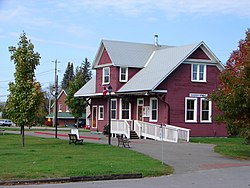
The historic train station is home of the South of 60 Arts' Centre, host to a variety of arts and craft shows, musical events and festivals. In 2008, the town re-opened the Radcliffe Hills Ski Area for snowboarding and downhill skiing. Barry's Bay was the Central Canada finalist in the 2006 CBC Hockeyville competition.

The community dedicated a park and monument to honour the construction of the Canadian Avro CF-105 Arrow and its chief test pilot, local resident Janusz Żurakowski. The CF-105 was an advanced Canadian designed-and-built interceptor that was instrumental in the advancement of aviation technology in the late 1950s and early 1960s.

Education

Barry's Bay is the site of Our Lady Seat of Wisdom College (OLSWC), an accredited Catholic liberal arts post-secondary institution established in 2000. [6] As of the 2019–2020 school year, OLSWC had a student body of 110 full-time Canadian and international students. [7]

See also

Related Research Articles

<span class="mw-page-title-main">Arnprior</span> Town in Ontario, Canada

Arnprior is a town in Renfrew County, in the eastern portion of Southern Ontario, Canada. It is located 65 km (40 mi) west of Downtown Ottawa, at the confluence of the Madawaska River and the Ottawa River in the Ottawa Valley. Arnprior has experienced significant growth in populations with the widening of the 417 Provincial Highway to four lanes. The town experienced an increase in population by 8.4% from 2011 to 2016, at which time its population was 8,795. The town is a namesake of Arnprior, Scotland, and is known for lumber, hydro power generation, aerospace, farming and its proximity to the National Capital Region.

<span class="mw-page-title-main">Lanark County</span> County in Ontario, Canada

Lanark County is a county located in the Canadian province of Ontario. Its county seat is Perth, which was first settled in 1816.

<span class="mw-page-title-main">McNab/Braeside</span> Township in Ontario, Canada

McNab/Braeside is a township in eastern Ontario, Canada, on the south shore of Chats Lake, straddling the lower Madawaska River in Renfrew County.

<span class="mw-page-title-main">Renfrew, Ontario</span> Town in Ontario, Canada

Renfrew is a town on the Bonnechere River in Renfrew County, Ontario, Canada. Located one hour west of Ottawa in Eastern Ontario, Renfrew is the fourth largest town in the county after Petawawa, Pembroke and Arnprior. The town is a small transportation hub connecting Highway 60 and Highway 132 with the Trans-Canada Highway. Renfrew is also known historically for its role in the formation of the National Hockey League. It lies about 5 kilometres from the Quebec border, about 10 kilometres by road. Renfrew makes most of Canada’s hockey tape.

<span class="mw-page-title-main">Bonnechere River</span> River in Ontario, Canada

The Bonnechere River is a river in the Saint Lawrence River drainage basin in Nipissing District and Renfrew County in eastern and northeastern Ontario, Canada. The river flows from Algonquin Provincial Park to the Ottawa River east and north of the town of Renfrew. The river's name is thought to come from the French "bonne chère" meaning "good cheer".

<span class="mw-page-title-main">Wilno, Ontario</span> Unincorporated settlement in Ontario, Canada

Wilno is a settlement in the Township Municipality of Madawaska Valley, Renfrew County, Ontario, Canada.

King's Highway 60, commonly referred to as Highway 60, is a provincially maintained highway in the Canadian province of Ontario. The 255.8-kilometre (158.9 mi) highway serves as the primary corridor through Algonquin Provincial Park, where it is dedicated as the Frank McDougall Parkway. East of Algonquin Park, the route serves east–west traffic in the highlands of central Ontario. It begins at Highway 11 in Huntsville and ends at Highway 17 near Renfrew.

<span class="mw-page-title-main">Polish Canadians</span> Canadians with Polish ancestry

Polish Canadians are citizens of Canada with Polish ancestry, and Poles who immigrated to Canada from abroad. At the 2016 Census, there were 1,106,585 Canadians who claimed full or partial Polish heritage.

<span class="mw-page-title-main">Killaloe, Ontario</span> Village in Ontario, Ontario

<span class="mw-page-title-main">Madawaska Valley, Ontario</span> Township in Ontario, Canada

The Township of Madawaska Valley is a township municipality in Renfrew County, Ontario, Canada. It was formed in 2001 through the amalgamation of the village of Barry's Bay and the townships of Radcliffe and Sherwood Jones & Burns. It includes the settlements of Combermere and Wilno.

<span class="mw-page-title-main">Greater Madawaska</span> Township municipality in Ontario, Canada

Greater Madawaska is an incorporated township in Renfrew County in eastern Ontario, Canada, created on January 1, 2001, through the amalgamation of the Township of Bagot and Blythfield; the Township of Brougham; and the Township of Griffith and Matawatchan. As of 2011, it has a population of 2,518.

Thomas Patrick Murray was an Ontario lumber merchant and political figure.

<span class="mw-page-title-main">Bark Lake</span>

Bark Lake is a lake on the border between the Township of Madawaska Valley in Renfrew County and the Township of South Algonquin, in Nipissing District in Ontario, Canada. It lies near Madawaska, Ontario, on the Madawaska River where the tributary Opeongo River joins.

<span class="mw-page-title-main">Pembroke, Ontario</span> City in Ontario, Canada

Pembroke is a city in the Canadian province of Ontario at the confluence of the Muskrat River and the Ottawa River in the Ottawa Valley. Pembroke is the location of the administrative headquarters of Renfrew County, though the city itself is politically independent. It is 145 kilometres (90 mi) northwest of Ottawa.

<span class="mw-page-title-main">Opeongo Hills</span>

The Opeongo Hills are a range of hills in Southern Ontario, near Algonquin Provincial Park. The hills stretch from Opeongo Lake in Algonquin Park in the west, along the Madawaska and Opeongo Rivers, towards the Opeongo Colonization Road, and extending towards the Deacon Escarpment, Bonnechere, Ontario, and Dacre in the east. To the east of the Opeongo Hills lie the Madawaska River valley, the Mississippi River Valley, and the Ottawa-Bonnechere Graben along the Ottawa River. Its tallest peak is roughly 7 km northeast of Highway 60. At roughly 586 meters, it is the tallest point in Southern Ontario. The community of Foymount is one of the highest settlements in Southern Ontario.

Madawaska Valley District High School (MVDHS) is a public high school situated in the village of Barry's Bay, Ontario. It is managed by Renfrew County District School Board. The school was opened in 1967, and has been operating as the public high school for the area ever since. M.V.D.H.S. is one of few high schools in the area, and as of 2012, is attended by 419 students, offering classes for students in grades 9-12. Some of the faculty are M.V. Graduates. In 2016 The Schools "Sherwood Public School" And "Madawaska Valley District High School" merged Into One Building.

Kamaniskeg Lake is a lake in the municipalities of Hastings Highlands, Hastings County, and Madawaska Valley, Renfrew County, in Southern Ontario, Canada. It is part of the Ottawa River drainage basin and is located in the Madawaska River Valley, with nearby communities of Barry's Bay and Combermere. The lake is known for its simple beauty, with a mixture of forest, and rock and sand beaches.

<span class="mw-page-title-main">Brudenell</span> Community in Ontario, Canada

Brudenell is a community in the township of Brudenell, Lyndoch and Raglan in Renfrew County, Ontario, Canada.

Our Lady Seat of Wisdom College (SWC), formerly Our Lady Seat of Wisdom Academy, is a private Catholic liberal arts college located in Barry's Bay, Ontario, Canada. The college offers a three-year Bachelor of Catholic Studies program with concentrations in Theology, Philosophy, History, Literature, and Classical and Early Christian Studies, as well as studies in mathematics, Languages, Sacred Music, Fine Arts, Natural and Social Sciences. SWC is known for its traditional Catholic teaching and values.

References

  1. "Barry's Bay". Census Profile, 2016 Census. Statistics Canada. Retrieved 27 March 2018.
  2. 1 2 3 Villeneuve Lorbetskie, Angela (1983 and 2009 material); Corrigan, Bob (2004 material). "A Short History of Barry's Bay". Barry's Bay Public Library. Archived from the original on 2012-04-04. Retrieved 2011-11-18.
  3. "Township of Madawaska Valley". Renfrew County . 2009-02-24. Archived from the original on 2009-02-25. Retrieved 2009-05-04.
  4. Blank, Joshua C. (2016). Creating Kashubia: History, Memory and Identity in Canada's First Polish Community. Montreal & Kingston: McGill–Queen's University Press. p. 3. ISBN   978-0-7735-4719-3 . Retrieved 2020-11-11 via Google Books.
  5. Hamilton, William B. (1978). The Macmillan Book of Canadian Place Names. Toronto: Macmillan of Canada. p. 160. ISBN   978-0-7705-1524-9 via Google Books.
  6. "Our History". Our Lady Seat of Wisdom College . Retrieved 2018-03-05.
  7. "Quick Facts". Our Lady Seat of Wisdom College . 2019. Retrieved 2020-11-11.