External links
| | This article about a scientific organization is a stub. You can help Wikipedia by expanding it. |
| | This climatology-related article is a stub. You can help Wikipedia by expanding it. |
Baseline Surface Radiation Network (BSRN) is a project of the World Climate Research Programme (WCRP) and the Global Energy and Water Cycle Experiment (GEWEX) and as such is aimed detecting important changes in the Earth's radiation field at the Earth's surface which may be related to climate changes. The central archive of the BSRN is the World Radiation Monitoring Center (WRMC) which was initiated by Atsumu Ohmura in 1992 and operated at ETH until 2007. Since 2008 the WRMC is operated by the Alfred Wegener Institute for Polar and Marine Research (AWI), Germany.
| | This article about a scientific organization is a stub. You can help Wikipedia by expanding it. |
| | This climatology-related article is a stub. You can help Wikipedia by expanding it. |
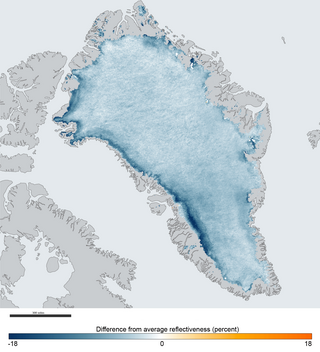
Albedo is the fraction of sunlight that is diffusely reflected by a body. It is measured on a scale from 0 to 1.
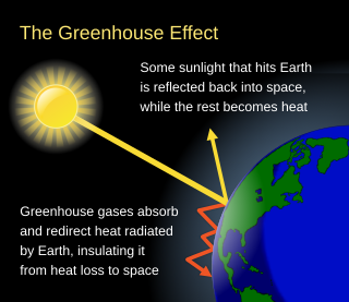
The greenhouse effect occurs when greenhouse gases in a planet's atmosphere cause some of the heat radiated from the planet's surface to build up at the planet's surface. This process happens because stars emit shortwave radiation that passes through greenhouse gases, but planets emit longwave radiation that is partly absorbed by greenhouse gases. That difference reduces the rate at which a planet can cool off in response to being warmed by its host star. Adding to greenhouse gases further reduces the rate a planet emits radiation to space, raising its average surface temperature.

Numerical climate models use quantitative methods to simulate the interactions of the important drivers of climate, including atmosphere, oceans, land surface and ice. They are used for a variety of purposes from study of the dynamics of the climate system to projections of future climate. Climate models may also be qualitative models and also narratives, largely descriptive, of possible futures.
Cloud feedback is the coupling between cloudiness and surface air temperature where a surface air temperature change leads to a change in clouds, which could then amplify or diminish the initial temperature perturbation. Cloud feedbacks can affect the magnitude of internally generated climate variability or they can affect the magnitude of climate change resulting from external radiative forcings.

The cryosphere is an all-encompassing term for the portions of Earth's surface where water is in solid form, including sea ice, lake ice, river ice, snow cover, glaciers, ice caps, ice sheets, and frozen ground. Thus, there is a wide overlap with the hydrosphere. The cryosphere is an integral part of the global climate system with important linkages and feedbacks generated through its influence on surface energy and moisture fluxes, clouds, precipitation, hydrology, atmospheric and oceanic circulation. Through these feedback processes, the cryosphere plays a significant role in the global climate and in climate model response to global changes. Approximately 10% of the Earth's surface is covered by ice, but this is rapidly decreasing. The term deglaciation describes the retreat of cryospheric features. Cryology is the study of cryospheres.

Space weather is a branch of space physics and aeronomy, or heliophysics, concerned with the time varying conditions within the Solar System, including the solar wind, emphasizing the space surrounding the Earth, including conditions in the magnetosphere, ionosphere, thermosphere, and exosphere. Space weather is distinct from, but conceptually related to, the terrestrial weather of the atmosphere of Earth. The term "space weather" was first used in the 1950s and came into common usage in the 1990s. Later, it was generalized to a "space climate" research discipline, which focuses on general behaviors of longer and larger-scale variabilities and effects.

Radiative forcing is the change in energy flux in the atmosphere caused by natural or anthropogenic factors of climate change as measured in watts per meter squared. It is a scientific concept used to quantify and compare the external drivers of change to Earth's energy balance. System feedbacks and internal variability are related concepts, encompassing other factors that also influence the direction and magnitude of imbalance.

Clouds and the Earth's Radiant Energy System (CERES) is on-going NASA climatological experiment from Earth orbit. The CERES are scientific satellite instruments, part of the NASA's Earth Observing System (EOS), designed to measure both solar-reflected and Earth-emitted radiation from the top of the atmosphere (TOA) to the Earth's surface. Cloud properties are determined using simultaneous measurements by other EOS instruments such as the Moderate Resolution Imaging Spectroradiometer (MODIS). Results from the CERES and other NASA missions, such as the Earth Radiation Budget Experiment (ERBE), could enable nearer to real-time tracking of Earth's energy imbalance and better understanding of the role of clouds in global climate change.

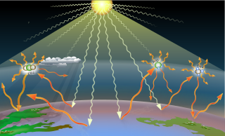
Earth's energy budget accounts for the balance between the energy that Earth receives from the Sun and the energy the Earth loses back into outer space. Smaller energy sources, such as Earth's internal heat, are taken into consideration, but make a tiny contribution compared to solar energy. The energy budget also accounts for how energy moves through the climate system. Because the Sun heats the equatorial tropics more than the polar regions, received solar irradiance is unevenly distributed. As the energy seeks equilibrium across the planet, it drives interactions in Earth's climate system, i.e., Earth's water, ice, atmosphere, rocky crust, and all living things. The result is Earth's climate.

Solar irradiance is the power per unit area received from the Sun in the form of electromagnetic radiation in the wavelength range of the measuring instrument. Solar irradiance is measured in watts per square metre (W/m2) in SI units.

The National Institute of Water and Atmospheric Research or NIWA, is a Crown Research Institute of New Zealand. Established in 1992, NIWA conducts research across a broad range of disciplines in the environmental sciences. It also maintains nationally and, in some cases, internationally important environmental monitoring networks, databases, and collections.

The Atmospheric Radiation Measurement Climate Research Facility is a multi-laboratory United States Department of Energy scientific user facility used for national and international global climate research efforts.

A runaway greenhouse effect occurs when a planet's atmosphere contains greenhouse gas in an amount sufficient to block thermal radiation from leaving the planet, preventing the planet from cooling and from having liquid water on its surface. A runaway version of the greenhouse effect can be defined by a limit on a planet's outgoing longwave radiation which is asymptotically reached due to higher surface temperatures evaporating water into the atmosphere, increasing its optical depth. This positive feedback means the planet cannot cool down through longwave radiation and continues to heat up until it can radiate outside of the absorption bands of the water vapour.
The Global Climate Observing System (GCOS) was established in 1992 as an outcome of the Second World Climate Conference, to ensure that the observations and information needed to address climate-related issues are obtained and made available to all potential users. The GCOS is co-sponsored by the World Meteorological Organization (WMO), the Intergovernmental Oceanographic Commission (IOC) of UNESCO, the United Nations Environment Programme (UNEP), and the International Council for Science (ICSU). In order to assess and monitor the adequacy of in-situ observation networks as well as satellite-based observing systems, GCOS regularly reports on the adequacy of the current climate observing system to the United Nations Framework Convention on Climate Change (UNFCCC), and thereby identifies the needs of the current climate observing system.

Longwave (LW) radiation, in the context of climate science, is electromagnetic thermal radiation emitted by Earth's surface, atmosphere, and clouds. Longwave radiation may also be referred to as terrestrial radiation, thermal infrared radiation, or thermal radiation. This radiation is in the infrared portion of the spectrum, but is distinct from the shortwave (SW) near-infrared radiation found in sunlight.
The Global Energy and Water Exchanges Project is an international research project and a core project of the World Climate Research Programme (WCRP).

The temperatures of a planet's surface and atmosphere are governed by a delicate balancing of their energy flows. The idealized greenhouse model is based on the fact that certain gases in the Earth's atmosphere, including carbon dioxide and water vapour, are transparent to the high-frequency solar radiation, but are much more opaque to the lower frequency infrared radiation leaving Earth's surface. Thus heat is easily let in, but is partially trapped by these gases as it tries to leave. Rather than get hotter and hotter, Kirchhoff's law of thermal radiation says that the gases of the atmosphere also have to re-emit the infrared energy that they absorb, and they do so, also at long infrared wavelengths, both upwards into space as well as downwards back towards the Earth's surface. In the long-term, the planet's thermal inertia is surmounted and a new thermal equilibrium is reached when all energy arriving on the planet is leaving again at the same rate. In this steady-state model, the greenhouse gases cause the surface of the planet to be warmer than it would be without them, in order for a balanced amount of heat energy to finally be radiated out into space from the top of the atmosphere.
A greenhouse gas is a gas that absorbs radiant energy at thermal infrared wavelengths. Greenhouse gases cause the greenhouse effect by absorbing some of the heat a planet's surface radiates in response to light from its host star (which is the sun in the case of planet Earth). The primary greenhouse gases in Earth's atmosphere are water vapor (H2O), carbon dioxide (CO2), methane (CH4), nitrous oxide (N2O), and ozone (O3). Without greenhouse gases, the average temperature of Earth's surface would be about −18 °C (0 °F), rather than the present average of 15 °C (59 °F).
The World Radiation Monitoring Center (WRMC) is the central archive of all Baseline Surface Radiation Network measurements. In 1992 the WRMC was founded at ETH Zurich. Since 2008-07-01 the WRMC is hosted by the Alfred Wegener Institute. Data were transferred to AWI from the original ftp-site at ETH Zurich until about 2008-03-01. More recent data were submitted directly to AWI were all data are archived in the ftp-server. Additionally, data are available via PANGAEA - Data Publisher for Earth & Environmental Science.
The skin temperature of an atmosphere is the temperature of a hypothetical thin layer high in the atmosphere that is transparent to incident solar radiation and partially absorbing of infrared radiation from the planet. It provides an approximation for the temperature of the tropopause on terrestrial planets with greenhouse gases present in their atmospheres.