Petroleum geology is the study of origin, occurrence, movement, accumulation, and exploration of hydrocarbon fuels. It refers to the specific set of geological disciplines that are applied to the search for hydrocarbons.

Sedimentary basins are region-scale depressions of the Earth's crust where subsidence has occurred and a thick sequence of sediments have accumulated to form a large three-dimensional body of sedimentary rock. They form when long-term subsidence creates a regional depression that provides accommodation space for accumulation of sediments. Over millions or tens or hundreds of millions of years the deposition of sediment, primarily gravity-driven transportation of water-borne eroded material, acts to fill the depression. As the sediments are buried, they are subject to increasing pressure and begin the processes of compaction and lithification that transform them into sedimentary rock.
Thermal history modelling is an exercise undertaken during basin modelling to evaluate the temperature history of stratigraphic layers in a sedimentary basin.

Kerogen is solid, insoluble organic matter in sedimentary rocks. It consists of a variety of organic materials, including dead plants, algae, and other microorganisms, that have been compressed and heated by geological processes. All the kerogen on earth is estimated to contain 1016 tons of carbon. This makes it the most abundant source of organic compounds on earth, exceeding the total organic content of living matter 10,000-fold.
Vitrinite is one of the primary components of coals and most sedimentary kerogens. Vitrinite is a type of maceral, where "macerals" are organic components of coal analogous to the "minerals" of rocks. Vitrinite has a shiny appearance resembling glass (vitreous). It is derived from the cell-wall material or woody tissue of the plants from which coal was formed. Chemically, it is composed of polymers, cellulose and lignin.

In geology, a rift is a linear zone where the lithosphere is being pulled apart and is an example of extensional tectonics. Typical rift features are a central linear downfaulted depression, called a graben, or more commonly a half-graben with normal faulting and rift-flank uplifts mainly on one side. Where rifts remain above sea level they form a rift valley, which may be filled by water forming a rift lake. The axis of the rift area may contain volcanic rocks, and active volcanism is a part of many, but not all, active rift systems.
The abiogenic petroleum origin hypothesis proposes that most of earth's petroleum and natural gas deposits were formed inorganically. Scientific evidence overwhelmingly supports a biogenic origin for most of the world's petroleum deposits. Mainstream theories about the formation of hydrocarbons on earth point to an origin from the decomposition of long-dead organisms, though the existence of hydrocarbons on extraterrestrial bodies like Saturn's moon Titan indicates that hydrocarbons are sometimes naturally produced by inorganic means. A historical overview of theories of the abiogenic origins of hydrocarbons has been published.
Sedimentary basin analysis is a geologic method by which the formation and evolution history of a sedimentary basin is revealed, by analyzing the sediment fill and subsidence. Subsidence of sedimentary basins generates the spatial distribution of accommodation infilling sediments. Aspects of the sediment, namely its composition, primary structures, and internal architecture, can be synthesized into a history of the basin fill. Such a synthesis can reveal how the basin formed, how the sediment fill was transported or precipitated, and reveal sources of the sediment fill. From such syntheses models can be developed to explain broad basin formation mechanisms. Examples of such basin classifications include intracratonic, rift, passive margin, strike-slip, forearc, backarc-marginal sea, fold and thrust belt, and foreland basins.
Petroleum geochemistry is the branch of geochemistry which deals with the application of chemical principles in the study of the origin, generation, migration, accumulation, and alteration of petroleum...(John M. Hunt, 1979). Petroleum is generally considered oil and natural gases having various compounds composed of primarily hydrogen and carbon. They are usually generated from the decomposition and/or thermal maturation of organic matter. The organic matter originated from plants and algae. The organic matter is deposited after the death of the plant in sediments, where after considerable time, heat, and pressure the compounds in the plants and algae are altered to oil, gas, and kerogen. Kerogen can be thought of as the remaining solid material of the plant. The sediment - usually clay and/or calcareous (lime) ooze, hardens during this alteration process into rock i.e. shale and/or limestone. The shale or limestone rock containing the organic matter is called the source rock because it is the source, having generated the petroleum.

The geology of the Falkland Islands is described in several publications. The Falkland Islands are located on a projection of the Patagonian continental shelf. In ancient geological time this shelf was part of Gondwana, which around 400 million years ago broke from what is now Africa and drifted westwards relative to Africa. Studies of the seabed surrounding the islands indicated the possibility of oil. Intensive exploration began in 1996, although there had been some earlier seismic surveys in the region.
In petroleum geology, the maturity of a rock is a measure of its state in terms of hydrocarbon generation. Maturity is established using a combination of geochemical and basin modelling techniques.
Fred F. Meissner was an American geologist and engineer who contributed to the fields of geology, geophysics, engineering, petroleum engineering, geochemistry, mineralogy, physics, mining, economic geology, and fishing.
In petroleum geology, source rock is rock which has generated hydrocarbons or which could generate hydrocarbons. Source rocks are one of the necessary elements of a working petroleum system. They are organic-rich sediments that may have been deposited in a variety of environments including deep water marine, lacustrine and deltaic. Oil shale can be regarded as an organic-rich but immature source rock from which little or no oil has been generated and expelled. Subsurface source rock mapping methodologies make it possible to identify likely zones of petroleum occurrence in sedimentary basins as well as shale gas plays.

In structural geology section restoration or palinspastic restoration is a technique used to progressively undeform a geological section in an attempt to validate the interpretation used to build the section. It is also used to provide insights into the geometry of earlier stages of the geological development of an area. A section that can be successfully undeformed to a geologically reasonable geometry, without change in area, is known as a balanced section.

The Jeanne d'Arc Basin is an offshore sedimentary basin located about 340 kilometres to the basin centre, east-southeast of St. John's, Newfoundland and Labrador. This basin formed in response to the large scale plate tectonic forces that ripped apart the super-continent Pangea and also led to sea-floor spreading in the North Atlantic Ocean. This basin is one of a series of rift basins that are located on the broad, shallow promontory of continental crust known as the Grand Banks of Newfoundland off Canada's east coast. The basin was named after a purported 20 metres shoal labelled as "Ste. Jeanne d'Arc" on out-dated bathymetric charts and which was once thought to represent a local exposure of basement rocks similar to the Virgin Rocks.

The Foraminiferal Colouration Index (FCI) is a tool for assessing the thermal alteration of organic matter buried in sedimentary rock. It uses temperature-controlled colour changes in the organic cement of agglutinated foraminifera (microfossils) to estimate thermal alteration. The method is empirical and based on determination of colour by visual comparison of fossil specimens to the Geological Society of America Rock-Color Chart under a binocular microscope.
The Halibut Field is an oil field, within the Gippsland Basin offshore of the Australian state of Victoria. The oil field is located approximately 64 km offshore of southeastern Australia. The total area of this field is 26.9 km2 and is composed of 10 mappable units.
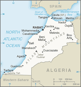
The Tarfaya Basin is a structural basin located in southern Morocco that extends westward into the Moroccan territorial waters in the Atlantic Ocean. The basin is named for the city of Tarfaya located near the border of Western Sahara, a region governed by the Kingdom of Morocco. The Canary Islands form the western edge of the basin and lie approximately 100 km to the west.

The Greater Green River Basin (GGRB) is a 21,000 square mile basin located in Southwestern Wyoming. The Basin was formed during the Cretaceous period sourced by underlying Permian and Cretaceous deposits. The GGRB is host to many anticlines created during the Laramide Orogeny trapping many of its hydrocarbon resources. It is bounded by the Rawlins Uplift, Uinta Mountains, Sevier overthrust belt, Sierra Madre Mountains, and the Wind River Mountain Range. The Greater Green River Basin is subdivided into four smaller basins, the Green River Basin, Great Divide Basin, Washakie Basin, and Sand Wash Basin. Each of these possesses hydrocarbons that have been economically exploited. There are 303 named fields throughout the basin, the majority of which produce natural gas; the largest of these gas fields is the Jonah Field.
The Officer Basin is an intracratonic sedimentary basin that covers roughly 320,000 km2 along the border between southern and western Australia. Exploration for hydrocarbons in this basin has been sparse, but the geology has been examined for its potential as a hydrocarbon reservoir. This basin's extensive depositional history, with sedimentary thicknesses exceeding 6 km and spanning roughly 350 Ma during the Neoproterozoic, make it an ideal candidate for hydrocarbon production.