
Dartmouth is a town and civil parish in the English county of Devon. It is a tourist destination set on the western bank of the estuary of the River Dart, which is a long narrow tidal ria that runs inland as far as Totnes. It lies within the South Devon Area of Outstanding Natural Beauty and South Hams district, and had a population of 5,512 in 2001, reducing to 5,064 at the 2011 census. There are two electoral wards in the Dartmouth area. Their combined population at the above census was 6,822.
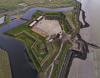
Tilbury Fort, also known historically as the Thermitage Bulwark and the West Tilbury Blockhouse, is an artillery fort on the north bank of the River Thames in England. The earliest version of the fort, comprising a small blockhouse with artillery covering the river, was constructed by King Henry VIII to protect London against attack from France as part of his Device programme. It was reinforced during the 1588 Spanish Armada invasion scare, after which it was reinforced with earthwork bastion, and Parliamentary forces used it to help secure the capital during the English Civil War of the 1640s. Following naval raids during the Anglo-Dutch Wars, the fort was enlarged by Sir Bernard de Gomme from 1670 onwards to form a star-shaped defensive work, with angular bastions, water-filled moats and two lines of guns facing onto the river.

Deal Castle is an artillery fort constructed by Henry VIII in Deal, Kent, between 1539 and 1540. It formed part of the King's Device programme to protect against invasion from France and the Holy Roman Empire, and defended the strategically important Downs anchorage off the English coast. Comprising a keep with six inner and outer bastions, the moated stone castle covered 0.85 acres (0.34 ha) and had sixty-six firing positions for artillery. It cost the Crown a total of £27,092 to build the three castles of Deal, Sandown and Walmer, which lay adjacent to one another along the coast and were connected by earthwork defences. The original invasion threat passed but, during the Second English Civil War of 1648–49, Deal was seized by pro-Royalist insurgents and was only retaken by Parliamentary forces after several months' fighting.

The Device Forts, also known as Henrician castles and blockhouses, were a series of artillery fortifications built to defend the coast of England and Wales by Henry VIII. Traditionally, the Crown had left coastal defences in the hands of local lords and communities but the threat of French and Spanish invasion led the King to issue an order, called a "device", for a major programme of work between 1539 and 1547. The fortifications ranged from large stone castles positioned to protect the Downs anchorage in Kent, to small blockhouses overlooking the entrance to Milford Haven in Pembrokeshire, and earthwork bulwarks along the Essex coast. Some forts operated independently, others were designed to be mutually reinforcing. The Device programme was hugely expensive, costing a total of £376,000 ; much of this was raised from the proceeds of the Dissolution of the Monasteries a few years before.
Pendennis Castle is an artillery fort constructed by Henry VIII near Falmouth, Cornwall, England between 1540 and 1542. It formed part of the King's Device programme to protect against invasion from France and the Holy Roman Empire, and defended the Carrick Roads waterway at the mouth of the River Fal. The original, circular keep and gun platform was expanded at the end of the century to cope with the increasing Spanish threat, with a ring of extensive stone ramparts and bastions built around the older castle. Pendennis saw service during the English Civil War, when it was held by the Royalists, and was only taken by Parliament after a long siege in 1646. It survived the interregnum and Charles II renovated the fortress after his restoration to the throne in 1660.
Dartmouth Castle is an artillery fort, built to protect Dartmouth harbour in Devon, England. The earliest parts of the castle date from the 1380s, when, in response to the threat of a French attack, the civic authorities created a small enclosure castle overlooking the mouth of the Dart estuary. This was intended to engage enemy ships with catapults and possibly early cannon, and incorporated the local chapel of Saint Petroc within its walls. At the end of the 15th century, the castle was expanded with an artillery tower and an iron chain which could be stretched across the harbour to a tower at Godmerock; this addition formed the oldest known purpose-built coast artillery fort in Britain. Further gun batteries were added during the French invasion scare of the 1540s.

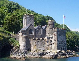
Kingswear Castle is an artillery fort, built to protect Dartmouth harbour in Devon, England. It was constructed between 1491 and 1502 in response to the threat of French attack and was one of the first purpose-built artillery forts in Britain. By the end of the 16th century, however, improvements in the range of artillery weapons had reduced the utility of the castle. It took part in the English Civil War and continued to be armed until the early 18th century, but fell into ruin. Restored as a summer house in 1855, in the 21st century it is managed by the Landmark Trust as a holiday let.

St Mawes Castle is an artillery fort constructed by Henry VIII near Falmouth, Cornwall, between 1540 and 1542. It formed part of the King's Device programme to protect against invasion from France and the Holy Roman Empire, and defended the Carrick Roads waterway at the mouth of the River Fal. The castle was built under the direction of Thomas Treffry to a clover leaf design, with a four-storey central tower and three protruding, round bastions that formed gun platforms. It was initially armed with 19 artillery pieces, intended for use against enemy shipping, operating in partnership with its sister castle of Pendennis on the other side of the estuary. During the English Civil War, St Mawes was held by Royalist supporters of King Charles I, but surrendered to a Parliamentary army in 1646 in the final phase of the conflict.

St Catherine's Castle is a Henrician castle in Cornwall, England, built by Thomas Treffry between approximately 1538 and 1540, in response to fears of an invasion of England by France and the Holy Roman Empire. The D-shaped, stone fortification, equipped with five gun-ports for cannon, overlooked the mouth of the River Fowey in Cornwall. It was protected by a curtain wall and the surrounding cliffs. The castle remained in use for many years until it was closed at the end of the Napoleonic Wars in 1815. Brought back into service in 1855 during the Crimean War, it was fitted with two new artillery positions, but it soon became obsolete and was abandoned. During the Second World War the castle was refortified and used to house a battery of naval guns, protecting the coast against the threat of German attack. At the end of the conflict the castle was restored to its previous condition and is now managed by English Heritage as a tourist attraction.

Cromwell's Castle is an artillery fort overlooking New Grimsby harbour on the island of Tresco in the Isles of Scilly. It comprises a tall, circular gun tower and an adjacent gun platform, and was designed to prevent enemy naval vessels from entering the harbour. The castle was built in two phases; Sir Robert Blake constructed the tower between 1651 and 1652 in the aftermath of the Parliamentary invasion of the islands at the end of the English Civil War, and Master Gunner Abraham Tovey added the gun platform during the War of Jenkins' Ear around 1739. The tower fell into disuse soon afterwards, and in the 21st century is managed by English Heritage and open to visitors.

Hull Castle was an artillery fort in Kingston upon Hull in England. Together with two supporting blockhouses, it defended the eastern side of the River Hull, and was constructed by King Henry VIII to protect against attack from France as part of his Device programme in 1542. The castle had two large, curved bastions and a rectangular keep at its centre; the blockhouses to the north and south had three curved bastions supporting guns, and a curtain wall and moat linked the blockhouses and castle. The construction project used material from recently dissolved monasteries, and cost £21,056. The town took over responsibility for these defences in 1553, leading to a long running dispute with the Crown as to whether the civic authorities were fulfilling their responsibilities to maintain them.
King Charles's Castle is a ruined artillery fort overlooking New Grimsby harbour on the island of Tresco in the Isles of Scilly. Built between 1548 and 1551 to protect the islands from French attack, it would have held a battery of guns and an accompanying garrison, designed to prevent enemy vessels from entering the harbour. The castle is polygonal in design, constructed from granite stone, with the gun battery at the front, and a dining room, kitchen and living accommodation at the rear. An additional defensive earthwork was constructed around it during the 17th century. The design of the castle is unusual for the period, and is only seen elsewhere in blockhouses along the River Thames.

Dartmouth Harbour is a natural port located in Dartmouth, Devon, England. It is situated at the mouth of the River Dart on the English Channel. Bayard's Cove Fort is a small fort, which was built to defend the harbour's entrance. The crafts which dock at the port are mainly local fishing vessels, naval ships and luxury yachts; warships routinely visit the harbour. The River Dart is navigable from Dartmouth to the old weir location at Totnes.

The Old Blockhouse, also known as the Dover Fort, is a 16th-century fortification on the island of Tresco in the Isles of Scilly. It was built between 1548 and 1551 by the government of Edward VI to protect the islands against French attack.

The East and West Blockhouses were Device Forts built by King Henry VIII in 1539 to protect the harbour of Milford Haven in Wales. The two blockhouses were positioned on either side of the Milford Haven Waterway in the villages of Angle and Dale respectively, overlooking the sea. The East Blockhouse was never completed, but the remains were reused as a defensive site in the Second World War. The West Blockhouse was described by contemporaries as forming a round tower with gunports, but it was demolished when West Blockhouse Fort was built on the same site in the 19th century.
Milton Blockhouse was an artillery fortification constructed as part of Henry VIII's Device plan of 1539, in response to fears of an imminent invasion of England. It was built at Milton, near Gravesend in Kent at a strategic point along the River Thames, and was operational by 1540. Equipped with 30 pieces of artillery and a garrison of 12 men and a captain, it was probably a two-storey, D-shaped building, designed to prevent enemy ships from progressing further up the river or landing an invasion force. It was stripped of its artillery in 1553 and was demolished between 1557 and 1558; nothing remains of the building above ground, although archaeological investigations in the 1970s uncovered parts of the blockhouse's foundations.

Gravesend Blockhouse was an artillery fortification constructed as part of Henry VIII's Device plan of 1539, in response to fears of an imminent invasion of England by European countries. It was built at Gravesend in Kent at a strategic point along the River Thames and was operational by 1540. A two-storey, D-shaped building built from brick and stone, it had a circular bastion overlooking the river and gun platforms extending out to the east and west. It functioned in conjunction with Tilbury Fort on the other side of the river, and was repaired in 1588 to deal with the threat of Spanish invasion, and again in 1667 when the Dutch navy raided the Thames. A 1778 report recommended alterations to the blockhouse and its defences, leading to the remodelling of the gun platforms and the construction of the new, larger New Tavern Fort alongside it. In the 1830s the government decided to rely entirely on the newer fort and the old blockhouse was demolished in 1844. Its remains were uncovered in archaeological excavations between 1975 and 1976.
Mersea Fort, also known as Cudmore Grove Blockhouse, was an artillery fort established by Henry VIII on the East Mersea coast in 1543. It formed part of the King's Device programme to protect against invasion from France and the Holy Roman Empire, and defended the River Colne that led to the town of Colchester. It was triangular in shape, with earthwork walls and three bastions to hold artillery. It was demobilised in 1552, but was brought back into use several times over the next century and saw service during the Second English Civil War of 1648. The fort hosted an admiralty court to oversea the local oyster trade, until the dilapidation of the site forced the court to move to the Moot Hall in Colchester in the middle of the 18th century. A new gun battery was built at the fort during the Napoleonic Wars, but the fortification then fell into decline and was extensively damaged by the construction of a sea wall along the coast. The remains of the earthworks were excavated by archaeologists between 2002 and 2003.

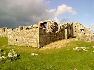
Harry's Walls are the remains of an unfinished artillery fort, started in 1551 by the government of Edward VI to defend the island of St Mary's in the Isles of Scilly. Constructed to defend the harbour of Hugh Town from possible French attack, the fortification incorporated Italianate-style bastions with protective orillons and would have been the most advanced design in the kingdom at the time. It was not completed, probably due to a shortage of funds and the passing of the invasion threat, and only the south-west side remains. In the 21st century, Harry's Walls are managed by English Heritage and open to visitors.


