
Hyde County is a county located in the U.S. state of North Carolina. As of the 2010 Census, the population was 5,810, making it the second-least populous county in North Carolina. Its county seat is Swan Quarter. The county was created in 1705 as Wickham Precinct. It was renamed Hyde Precinct in 1712 and gained county status in 1739.
Burke County is a county located in the U.S. state of North Carolina. As of 2010 census, the population was 90,912. Its county seat is Morganton.
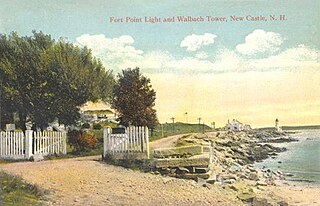
New Castle is a town in Rockingham County, New Hampshire, United States. The population was 968 at the 2010 census. It is the smallest and easternmost town in New Hampshire, and the only one located entirely on islands. It is home to Fort Constitution Historic Site, Fort Stark Historic Site, and the New Castle Common, a 31-acre (13 ha) recreation area on the Atlantic Ocean. New Castle is also home to a United States Coast Guard station, as well as the historic Wentworth by the Sea hotel.

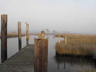
Ocracoke is a census-designated place (CDP) and unincorporated town located at the southern end of Ocracoke Island, located entirely within Hyde County, North Carolina, in the United States. The population was 948 as of the 2010 census. As of 2014, Ocracoke's population was estimated at 591. Ocracoke Island was the location of the pirate Blackbeard's death in November 1718.
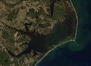
Pamlico Sound in North Carolina in the US is the largest lagoon along the North American East Coast, extending 80 mi (130 km) long and 15 to 20 miles wide. It is part of a large, interconnected network of lagoon estuaries that includes Albemarle Sound, Currituck Sound, Croatan Sound, Pamlico Sound, Bogue Sound, Core Sound, and Roanoke Sound. Together, these sounds, known as the Albemarle-Pamlico sound system, comprise the second largest estuary in the United States, covering over 3,000 sq. mi. of open water.(Chesapeake Bay is the largest.) The Pamlico Sound is separated from the Atlantic Ocean by the Outer Banks, a row of low, sandy barrier islands that include Cape Hatteras National Seashore, Cape Lookout National Seashore, and Pea Island National Wildlife Refuge. The Albemarle-Pamlico Sound is one of nineteen great waters recognized by the America's Great Waters Coalition.
Hatteras Island is a barrier island located off the North Carolina coast. Dividing the Atlantic Ocean and the Pamlico Sound, it runs parallel to the coast, forming a bend at Cape Hatteras. It is part of North Carolina's Outer Banks and includes the towns of Rodanthe, Waves, Salvo, Avon, Buxton, Frisco, and Hatteras. It contains the largest part of the Cape Hatteras National Seashore. It is almost entirely in Dare County, North Carolina, but there is a very small sliver of about 45 acres (0.18 km2) which extends southwest into Hyde County.

Portsmouth was a fishing and shipping village located on Portsmouth Island on the Outer Banks in North Carolina. Portsmouth Island is a tidal island connected, under most conditions, to north end of the North Core Banks, across Ocracoke Inlet from the village of Ocracoke. The town lies in Carteret County, was established in 1753 by the North Carolina Colonial Assembly, and abandoned in 1971. Its remains are now part of the Cape Lookout National Seashore.

Cape Hatteras National Seashore is a United States national seashore which preserves the portion of the Outer Banks of North Carolina from Bodie Island to Ocracoke Island, stretching over 70 miles (110 km), and is managed by the National Park Service. Included within this section of barrier islands along N.C. 12, but outside the national seashore boundaries, are Pea Island National Wildlife Refuge and several communities, such as Rodanthe, Buxton, and Ocracoke. Cape Hatteras is a combination of natural and cultural resources, and provides a wide variety of recreational opportunities.
Swan Quarter is an unincorporated community and census-designated place (CDP) in Hyde County, North Carolina, United States. It is the Hyde county seat. As of the 2010 census it had a population of 324.
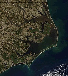
The Outer Banks is a 200-mile-long (320 km) string of barrier islands and spits off the coast of North Carolina and southeastern Virginia, on the east coast of the United States. They cover most of the North Carolina coastline, separating Currituck Sound, Albemarle Sound, and Pamlico Sound from the Atlantic Ocean.

Cedar Island is an island and a small coastal unincorporated community in eastern North Carolina. It is located in Carteret County. It was populated with local Native Americans prior to the arrival of European settlers. It is also the location of the state ferry transportation system dock where travel can be made across Pamlico Sound to the island and village of Ocracoke in Hyde County.

In North Carolina, the Crystal Coast is an 85-mile stretch of coastline that extends from the Cape Lookout National Seashore, which includes 56 miles of protected beaches, southwestward to the New River. The Crystal Coast is a popular area with tourists and second-home owners in the summer.
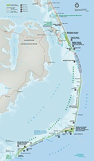
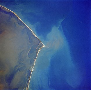
Hatteras Inlet is an estuary in North Carolina, located along the Outer Banks, separating Hatteras Island and Ocracoke Island. It connects the Atlantic Ocean to the Pamlico Sound. Hatteras Inlet is located entirely within Hyde County.

The Banker horse is a breed of feral horse living on barrier islands in North Carolina's Outer Banks. It is small, hardy, and has a docile temperament. Descended from domesticated Spanish horses and possibly brought to the Americas in the 16th century, the ancestral foundation bloodstock may have become feral after surviving shipwrecks or being abandoned on the islands by one of the exploratory expeditions led by Lucas Vázquez de Ayllón or Sir Richard Grenville. Populations are found on Ocracoke Island, Shackleford Banks, Currituck Banks, and in the Rachel Carson Estuarine Sanctuary.
Diamond City was a settlement on the eastern end of Shackleford Banks, in Carteret County, North Carolina. Due to the San Ciriaco hurricane that struck in August 1899, the approximately 500 residents of the settlement and island decided to move. The last of the residents had left by 1902, and even relocated houses to nearby places such as Harkers Island, Salter Path and Morehead City.
HMT Bedfordshire (FY141) was an armed naval trawler in the service of the Royal Naval Patrol Service during World War II. Transferred to the East Coast of the United States to assist the United States Navy with anti-submarine patrols, she was staffed by a British and Canadian crew. Bedfordshire was sunk by the German submarine U-558 on 11 May 1942 off the coast of Ocracoke Island in the Outer Banks of North Carolina, with the loss of all hands.
The Department of Virginia and North Carolina was a United States Military department encompassing Union-occupied territory in the Confederate States during the Civil War. In 1863 it was formed by the merging of two previously existing departments: the Department of Virginia and the Department of North Carolina. In 1865 the two departments were once again separated.

The Core Banks are barrier islands in North Carolina, part of the Outer Banks and Cape Lookout National Seashore. Named after the Coree tribe, they extend from Ocracoke Inlet to Cape Lookout, and consist of two low-relief narrow islands, North Core Banks and South Core Banks, and, since September 2011, two smaller islands. New Drum Inlet, Old Drum Inlet and Ophelia Inlet now separate the islands. The Core Banks are now uninhabited. However, Portsmouth, at the north end of the North Core Banks, was once a substantial port, and Cape Lookout Village, about one and half miles south of the Cape Lookout Lighthouse, contains the historic Lookout Life-Saving Station, a U.S. Coast Guard Station, and several island homes.
Mounted Boy Scout Troop 290 of Ocracoke, North Carolina, is one of the few mounted troops in the history of the Boy Scouts of America (BSA), and the only remaining. The troop was founded by United States Army Lieutenant Colonel Marvin Howard in 1954 and was active for about 10 years. They rode the feral Banker horses of North Carolina's Outer Banks. These horses were descended from horses that had either survived shipwrecks or early explorations from the 1500s–1700s along the Outer Banks. Though the ponies roamed free, they were considered livestock. In 1953, when the Cape Hatteras National Seashore was created, the Park Service banned free roaming livestock on the island. Efforts have been made to preserve the horses and improve their bloodline.


