The Vansycle I Wind Project is a wind farm in Umatilla County, Oregon. It consists of 38 Vestas 0.66 MW wind turbines at the upper end of Vansycle Canyon with a collective nameplate generating capacity of 25.08 MW. The project was the first commercial wind energy project constructed and operated in Oregon and began operation in December 1998.
Huxley Hill Wind Farm is a wind power station at King Island, Tasmania, Australia, of around 1600 residents, owned by Hydro Tasmania, which supplements the four diesel generators with a combined capacity of 6 MW at Currie Power Station. King Island also has a 100 kW solar capacity provided with monocrystaline solar panels on dual-axis arrays.

Equinox Mountain is a mountain in Bennington County, Vermont, United States, in the town of Manchester. The mountain is the highest peak of the Taconic Range, and the highest point of Bennington County. It is one of thirteen peaks in Vermont with a topographic prominence over 2,000 feet (610 m), ranked third behind Mansfield and Killington. Equinox is the second highest peak in southern Vermont, after Stratton Mountain.
Wind power has a history in Canada dating back many decades, particularly on prairie farms. As of December 2017, wind power generating capacity was 12,252 megawatts (MW), providing about 6% of Canada's electricity demand. The Canadian Wind Energy Association has outlined a future strategy for wind energy that would reach a capacity of 55 GW by 2025, meeting 20% of the country's energy needs.
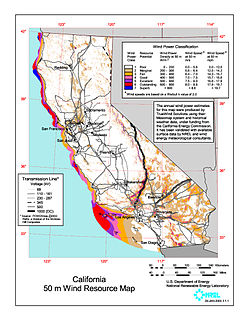
Wind power in California had initiative and early development during Governor Jerry Brown's first two terms in the late 1970s and early 1980s. The state's wind power capacity has grown by nearly 350% since 2001, when it was less than 1,700 MW. In 2016, wind energy supplied about 6.9% of California's total electricity needs, or enough to power more than 1.3 million households. Most of California's wind generation is found in the Tehachapi area of Kern County, California, with some big projects in Solano, Contra Costa and Riverside counties as well. California is among the states with the largest amount of installed wind power capacity. In recent years, California has lagged behind other states when it comes to the installation of wind power. It was ranked 4th overall for wind power electrical generation at the end of 2016 behind Texas, Iowa, and Oklahoma. As of December 31, 2016, California had 5,662 megawatts (MW) of wind powered electricity generating capacity.

The Wild Horse Wind Farm is a 273-megawatt wind farm that generates energy for Puget Sound Energy that consists of one hundred twenty seven 1.8-megawatt Vestas V80 turbines and twenty two 2.0-megawatt Vestas V80 turbines on a 10,800-acre (4,400 ha) site in Kittitas County, Washington, 17 miles (27 km) east of Ellensburg, Washington. The turbines are placed on the high open Shrub-steppe ridge tops of Whiskey Dick Mountain, which was chosen for its energetic wind resource, remote location, and access to nearby power transmission lines. The towers are 221 feet (67 m) tall, and each blade is 129 feet (39 m) long, with a total rotor diameter of 264 feet (80 m), larger than the wingspan of a Boeing 747. The turbines can begin producing electricity with wind speeds as low as 9 mph (14 km/h) and reach full production at 31 mph (50 km/h). They shut down at sustained wind speeds of 56 mph (90 km/h). The site is also home to one of the largest solar array (500 kW) in Washington.

Wind power in Ohio has a long history, and as of 2016, Ohio had 545 megawatt (MW) of utility-scale wind power installations installed, responsible for 1.1% of in-state electricity generated. Over 1000 MW more were under construction or pending approval. Some installations have become tourist attractions. There has been a sudden increase in generating capacity, as total windpower generation in the state in 2010 was just 9.7 MW.

Whitelee Wind Farm is the largest on-shore wind farm in the United Kingdom with 215 Siemens and Alstom wind turbines and a total capacity of 539 megawatts (MW), with the average of 2.5 MW per turbine. Whitelee was developed and is operated by ScottishPower Renewables, which is part of the Spanish company Iberdrola.

The name of the person after which the canyon is named is Bigelow, not Biglow. This was a mistake made in spelling after the time of naming.

Stetson Mountain is a small mountain located in Washington County, Maine; a 8-mile (13 km) long ridge running roughly north–south. The summit elevation is between 1,080 ft (330 m) and 1,090 ft (330 m). Stetson is approximately 10 miles (16 km) from the Canada–United States border with New Brunswick.

Kibby Wind Power Project is a wind farm on Kibby Mountain in Franklin County, Maine, United States of America.
There are a number of wind power projects in the state of Maine, totalling more than 900 MW in capacity and responsible for 13.85% of in-state electricity production. The largest single wind farm is the Bingham Wind Farm in Kingsbury Plantation with an installed capacity of 185 MW.

Twin Groves Wind Farm is a wind farm in the U.S. state of Illinois, near the villages of Arrowsmith, Saybrook, and Ellsworth in McLean County. It consists of 240 operating wind turbines. Each wind turbine stands 280 ft (80 m) tall and has three 120-foot-long (39 m) blades. The wind farm was constructed from 2007 to February 2008. Twin Groves was the largest utility-scale wind farm east of the Mississippi River upon completion.
Coopers Gap Wind Farm is a 453 megawatt wind power station under construction in the Bilboa and Cooranga North region, of Australia, approximately 50 kilometres (31 mi) south-west of Kingaroy and 65 km (40 mi) north of Dalby in Queensland, Australia.
The Hay Canyon Wind Farm is an electricity generating wind farm facility located in Moro, Oregon, United States. It is owned by Iberdrola Renewables and began operations in 2009. The facility has a generating capacity of 101 megawatts. The farm sells power to the Snohomish County Public Utility District.
The Dokie Ridge Wind Farm is a wind farm located near Chetwynd, British Columbia, Canada. It was put into commercial operation in 2011. The facility has a generating capacity of 144 megawatts and is produces 320 to 340 gigawatt-hours of energy per year. . Electrical engineering consulting services are provided by Lex Engineering Ltd. BC Hydro announced the project was in commercial operation as of February 16, 2011. The project was built in partnership between GE and Plutonic Power Corporation. The wind farm has 48 Vestas V90 3 MW turbines, an electrical substation and seven kilometers of transmission line. The project cost about $228 million (Canadian).
The Leaning Juniper Wind Project is an electricity generating wind farm facility located in Gilliam County, Oregon, United States with a total generating capacity of 301.5 megawatts. It is owned by PacifiCorp and began operations in 2006. Leaning Juniper I became operational in September 2006 with 67 1.5 MW wind turbines with a capacity of 100.5 megawatts. "Leaning Juniper II includes 133 GE 1.5 MW wind turbines with a capacity of 201 MW. This phase came online in 2011." The Jones Canyon Substation was built as part of this project and to support other wind projects in the area.

There are more than twenty wind power projects operating in the commonwealth of Pennsylvania. The most productive wind energy regions generally fall in mountain or coastal terrains. The northern portion of the Appalachian chain, including most of Southwestern Pennsylvania, is one of the areas with the highest potential for wind energy in the Eastern United States. The mountain ridges of central and northeastern Pennsylvania, including the Poconos in the eastern part of the state, offer some of the best wind resources in the region.
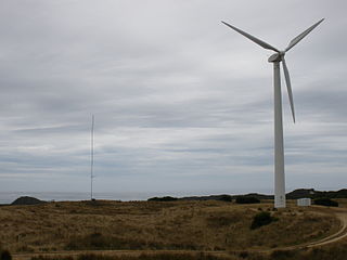
The great majority of wind turbines around the world belong to individuals or corporations who use them to generate electric power or to perform mechanical work. As such, wind turbines are primarily designed to be working devices. However, the large size and height above surroundings of modern industrial wind turbines, combined with their moving rotors, often makes them among the most conspicuous objects in their areas. A few localities have exploited the attention-getting nature of wind turbines by placing them on public display, either with visitor centers on their bases, or with viewing areas farther away. The wind turbines themselves are generally of conventional horizontal-axis, three-bladed design, and generate power to feed electrical grids, but they also serve the unconventional roles of technology demonstration, public relations, and education.

The Uppudaluwa Wind Farm is a 10.5 MW wind farm owned by PowerGen Lanka (Private) Limited in Uppudaluwa, Puttalam, Sri Lanka.


