Bear River (Michigan)

Last updated
Bear River

2009-0619-Petoskey-BearRiver1.JPG

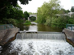
The Bear River flowing through downtown Petoskey
Country Michigan, United States
Physical characteristics
Main source Walloon Lake
River mouth Little Traverse Bay
Length 14.7 miles (23.7 km) [1]
Basin features
Tributaries
  • Left:
    Hay Marsh Creek
  • Right:
    Spring Brook

Bear River is a small clear slow-moving river in the U.S. state of Michigan. 14.7 miles (23.7 km) long, [1] it is the largest tributary of Little Traverse Bay in the northwest of the lower peninsula. Traverse Bay is on Lake Michigan. The river is formed as the outflow of Walloon Lake on the boundary between Charlevoix County and Emmet County, draining from the southeast end of the lake at 45°15′40″N84°56′01″W / 45.26111°N 84.93361°W / 45.26111; -84.93361 [2] near the community of Walloon Lake in Melrose Township. M-75 has its northern terminus in a junction with US 131 nearby.

U.S. state constituent political entity of the United States

In the United States, a state is a constituent political entity, of which there are currently 50. Bound together in a political union, each state holds governmental jurisdiction over a separate and defined geographic territory and shares its sovereignty with the federal government. Due to this shared sovereignty, Americans are citizens both of the federal republic and of the state in which they reside. State citizenship and residency are flexible, and no government approval is required to move between states, except for persons restricted by certain types of court orders. Four states use the term commonwealth rather than state in their full official names.

Michigan State of the United States of America

Michigan is a state in the Great Lakes and Midwestern regions of the United States. The state's name, Michigan, originates from the Ojibwe word mishigamaa, meaning "large water" or "large lake". With a population of about 10 million, Michigan is the tenth most populous of the 50 United States, with the 11th most extensive total area, and is the largest state by total area east of the Mississippi River. Its capital is Lansing, and its largest city is Detroit. Metro Detroit is among the nation's most populous and largest metropolitan economies.

Little Traverse Bay

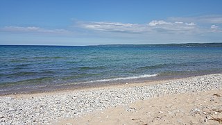
Little Traverse Bay is a small bay, 170 feet deep, off Lake Michigan in the northern area of the Lower Peninsula of Michigan. The cities of Harbor Springs and Petoskey are located on this bay.

Contents

The river flows east for about 2 miles (3 km) before turning north through Bear Creek Township, angling northwest to empty into Little Traverse Bay in Petoskey at 45°22′38″N84°57′39″W / 45.37722°N 84.96083°W / 45.37722; -84.96083 . [2] Petoskey was at first known as "Bear River" until being renamed in 1873. The Bear River itself has also been known as "Bear Creek" and "Ellis Creek". [2]

Bear Creek Township, Michigan Civil township in Michigan, United States

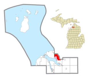
Bear Creek Township is a civil township of Emmet County in the U.S. state of Michigan. As of the 2000 census, the township population was 5,269.

Petoskey, Michigan City in Michigan, United States

Petoskey is a city and coastal resort community in the U.S. state of Michigan. The population was estimated at approximately close to 5,670 at the 2010 census. It is the county seat of Emmet County.

The river has excellent fishing and provides opportunities for peaceful canoeing or kayaking. The river is great for smelt fishing. For most of its path in Emmet County, River Road and the Tuscola and Saginaw Bay Railway parallel the river on its west banks.

Smelt (fish) family of fishes

Smelts are a family of small fish, the Osmeridae, found in the North Atlantic and North Pacific Oceans, as well as rivers, streams and lakes in Europe, North America and Northeast Asia. They are also known as freshwater smelts or typical smelts to distinguish them from the related Argentinidae, Bathylagidae, and Retropinnidae.

Tributaries

Drainage basin

Including Walloon Lake, the Bear River system drains all or portions of the following cities and townships:

Charlevoix County, Michigan County in the United States

Charlevoix County is a county in the U.S. state of Michigan. As of the 2010 census, the population was 25,949. The county seat is Charlevoix.

Bay Township, Michigan Civil township in Michigan, United States

Bay Township is a civil township of Charlevoix County in the U.S. state of Michigan. As of the 2010 census, the township population was 1,122. Bay Township's central village, Horton Bay, was featured in several of Ernest Hemingway's Nick Adams stories, including "The End of Something".

Boyne Valley Township, Michigan Civil township in Michigan, United States

Boyne Valley Township is a civil township of Charlevoix County in the U.S. state of Michigan. As of the 2010 census, the township population was 1,195. The township contains the village of Boyne Falls and the Boyne Mountain ski resort.

Related Research Articles

Emmet County, Michigan County in the United States

Emmet County is a county located in the U.S. state of Michigan. As of the 2010 census, the population was 32,694. The county seat is Petoskey.

Melrose Township, Michigan Civil township in Michigan, United States

Melrose Township is a civil township of Charlevoix County in the U.S. state of Michigan. The population was 1,403 at the 2010 census.

The Jordan River is a 24.9-mile-long (40.1 km) stream in the northwestern part of the lower peninsula in the U.S. state of Michigan. It is the largest tributary of Lake Charlevoix. The Jordan's headwaters rise from springs in the upper Jordan River Valley northeast of Mancelona in Antrim County. The Jordan River was the first river to be designated in Michigan's Natural Rivers Program.

St. Joseph River (Maumee River tributary) tributary of the Maumee River in Ohio and Indiana

The St. Joseph River is an 86.1-mile-long (138.6 km) tributary of the Maumee River in northwestern Ohio and northeastern Indiana in the United States, with headwater tributaries rising in southern Michigan. It drains a primarily rural farming region in the watershed of Lake Erie.

Walloon Lake lake in Charlevoix and Emmet counties, Michigan, United States

Walloon Lake is a glacier-formed lake located in Charlevoix and Emmet counties, just southwestward from the northern tip of the Lower Peninsula of Michigan. It is now home to many vacation homes and cottages. Though the end of the west arm of the lake is less than 1 mile (1.6 km) from Lake Michigan, Walloon Lake's surface elevation is over 100 feet (30 m) higher. The Bear River drains from the east end of the lake in Walloon Lake village, winding east then north down to its outflow into Lake Michigan at the south end of Petoskey.

Carp River is a 40.2-mile-long (64.7 km) river in Chippewa and Mackinac counties in the U.S. state of Michigan. 21.7 miles (34.9 km) of the river were added to the National Wild and Scenic Rivers System in 1992.

Petoskey State Park

Petoskey State Park is a public recreation area covering 303 acres (123 ha) on Lake Michigan in Bear Creek Township, Emmet County, Michigan. The state park is located 3 miles (4.8 km) northeast of the city of Petoskey on Little Traverse Bay. It is surrounded by heavily vegetated sand dunes that are excellent examples of parabolic dunes. Michigan's state stone, the Petoskey stone, can be found on the park beach.

Black River (Cheboygan County) tributary of the Cheboygan River in Michigan, United States

Black River is a 78.8-mile-long (126.8 km) river in the U.S. state of Michigan, flowing mostly northward through four Northern Michigan counties: Otsego, Montmorency, Presque Isle, and Cheboygan. The Black River flows into the Cheboygan River at 45°36′13″N84°27′47″W, just south of the city of Cheboygan, and then into Lake Huron. The main branch of the Black River rises in Charlton Township in east-central Otsego County near the boundary with Montmorency County. The East Branch of the Black River rises less than a mile to the east in Vienna Township in Montmorency County. The other major tributaries, Canada Creek, Tomahawk Creek and the Rainy River all rise in northern Montmorency County.

Black River (Southwest Michigan) river in southwest Michigan

Black River is a 4.2-mile-long (6.8 km) river in the southwest part of the U.S. state of Michigan that empties into Lake Michigan in South Haven at 42°24′08″N86°17′04″W, where it discharges past the South Pier Lighthouse. The river takes its name from the dark brown color of its water, which is caused by suspended sediments and organic materials picked up along its course. The river supports a variety of wildlife including trout, snapping turtles, leeches, and many other varieties of flora and fauna. The Black River watershed encompasses 287 square miles (740 km2) across two counties and 13 townships.

Cedar River is a 67.1-mile-long (108.0 km) river in the U.S. state of Michigan. It rises in the northern part of Menominee County at 45°53′18″N87°35′15″W and flows mostly south and east to empty into Green Bay of Lake Michigan at 45°24′35″N87°21′05″W in the community of Cedar River.

Rocky River (Michigan)

The Rocky River is a 28.3-mile-long (45.5 km) stream located in the southwest part of the U.S. state of Michigan that flows into the St. Joseph River at 41°56′33″N85°37′59″W in the city of Three Rivers in St. Joseph County. The Rocky River, along with the St. Joseph River and the Portage River, are the three rivers from which the city of Three Rivers takes its name.

Walloon Lake, Michigan Census-designated place & unincorporated community in Michigan, United States

Walloon Lake is an unincorporated community and census-designated place in Charlevoix County in the U.S. state of Michigan. As of the 2010 census it had a population of 290.

Cedar Creek may refer to several small streams in the U.S. state of Michigan:

Conway, Michigan Census-designated place & unincorporated community in Michigan, United States

Conway is an unincorporated community and census-designated place (CDP) in Emmet County, Michigan, United States. As of the 2010 census it had a population of 204.

Boyne River is a stream in Northern Michigan, named for the River Boyne in Leinster, Ireland. Together with the north and south branches, the river system has approximately 22 miles (35 km) of mainstream and the water basin drains 40,320 acres (163.2 km2). Boyne River is Lake Charlevoix's second-largest tributary, after the Jordan River.

Ocqueoc River river in the United States of America

The Ocqueoc River is stream in Presque Isle County in the northeastern part of the lower peninsula in the U.S. state of Michigan. It is 34.2 miles (55.0 km) long and encompasses a watershed of approximately 94,394 acres (382.00 km2).

Saganing River river in the United States of America

The Saganing River, also known as Saganing Creek, is a 10.0-mile-long (16.1 km) stream in the U.S. state of Michigan.

Spring Hill, Vigo County, Indiana Unincorporated community in Indiana, United States

Spring Hill is an unincorporated community in Honey Creek Township, Vigo County, in the U.S. state of Indiana.

The Little Pigeon River is a 6.0-mile-long (9.7 km) stream in Cheboygan County in the U.S. state of Michigan.

Little Cedar River is a 56.7-mile-long (91.2 km) river in Menominee County in the U.S. state of Michigan.

References