
The Province of Monza and Brianza,, is an administrative province of Lombardy region, Italy.

Sestriere is an alpine village in Italy, a comune (municipality) of the Metropolitan City of Turin. It is situated in Val Susa, 17 km (11 mi) from the French border. Its name derives from Latin: ad petram sistrariam, that is at sixty Roman miles from Turin.

Alpes Cottiae[alˈpeːs ˈkɔt.tjae̯] was a province of the Roman Empire, one of three small provinces straddling the Alps between modern France and Italy. Its name survives in the modern Cottian Alps. In antiquity, the province's most important duty was the safeguarding of communications over the Alpine passes.

Bardonecchia (Template:IPA-ita) is an Italian town and comune located in the Metropolitan City of Turin, in the Piedmont region, in the western part of Susa Valley. It grew out of a small village with the works for the Frejus Rail Tunnel, the first crossing the Alps. The town hosted the snowboarding events of the 2006 Winter Olympics.
The Plum River is a tributary of the Mississippi River, about 46.6 miles (75.0 km) long, in northwestern Illinois in the United States. It rises in Jo Daviess County and flows generally south-southwestwardly into Carroll County, where it joins the Mississippi at Savanna. Among its several short tributaries are:

Pragelato is a comune (municipality) in the Metropolitan City of Turin in the Italian region Piedmont, located about 60 kilometres (37 mi) west of Turin, in the upper Val Chisone. The name Pragelato, meaning "icy meadow", has been derived from the harsh climate and the fact that the ground is covered with ice for long periods. On both sides of the Chisone, extensive forests of pine and larch provide protection from the avalanches which are a common occurrence in the winter season: for this reason in the nineteenth century the people of Pragelato were only permitted to fell trees close to the mountain summits, and even then only with the permission of the communal administration.

Sauze d'Oulx is a town and comune in the Metropolitan City of Turin, Piedmont located 80 kilometres from Turin in the Val di Susa, at the foot of Monte Genevris (2,536 m).

Lake Çıldır, is a large freshwater lake in the Ardahan Province, northeastern part of Turkey. It is located at 41.0425°N 43.2552778°E, close to the borders with Georgia and Armenia. Lake Çıldır is located at the elevation of about 1,900 m (6,200 ft) and is surrounded by a mountainous region. It has an area of 123.00 km2 (47.49 sq mi) and a maximum depth of about 42 m (138 ft). Water from the lake is used for irrigation.

Cesana Torinese is a comune (municipality) in the Metropolitan City of Turin in the Italian region Piedmont, located about 70 kilometres (43 mi) west of Turin, on the border with France.

Exilles is a comune (municipality) in the Metropolitan City of Turin in the Italian region Piedmont, located about 60 kilometres (37 mi) west of Turin, on the border with France.

Salbertrand is a comune (municipality) in the Metropolitan City of Turin in the Italian region Piedmont, about 60 km west of Turin. At 31 December 2004 it had a population of 522 and an area of 40.9 km².
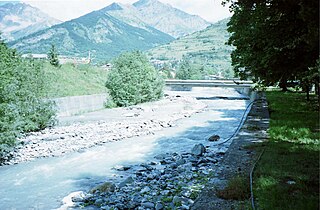
The Dora di Bardonecchia is a short tributary of the Dora Riparia river, lying entirely within the upper Susa Valley in the Metropolitan City of Turin, Piedmont, Italy.

Ocklawaha is an unincorporated community in Marion County, Florida, United States. The community is part of the Ocala Metropolitan Statistical Area.

Corod is a commune in Galați County, Romania. It is composed of four villages: Blânzi, Brătulești, Cărăpcești and Corod.
Runów-Osada is a settlement in the administrative district of Gmina Piaseczno, within Piaseczno County, Masovian Voivodeship, in east-central Poland.
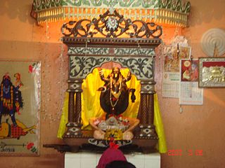
Boro Kali Bari is one of the oldest Hindu temples in the city of Mymensingh, Bangladesh. The temple is dedicated to the goddess Kali.
Figino is a district ("quartiere") of Milan, Italy, part of the Zone 7 administrative division. It is located north-west of the centre, within the Parco Agricolo Sud Milano nature reserve. Before being annexed to Milan, in 1869, it was an autonomous comune, named Figino di Milano.

Aiguille de Scolette or Pierre Menue is a mountain of Savoie (F) and of the province of Turin (I). It lies in the Cottian Alps and has an elevation of 3,506 metres above sea level.

Col d'Étache in French,, is a pedestrian pass across the Cottian Alps. It connects Susa Valley and Maurienne.


