The Zuid-Willemsvaart is a canal in the south of the Netherlands and the east of Belgium.
Helmond is a city and municipality in the Metropoolregio Eindhoven of the province of North Brabant in the Southern Netherlands.

Laarbeek is a municipality located in the province of North Brabant in the south of the Netherlands. It was formed in 1997 from the former municipalities Beek en Donk, Aarle-Rixtel and Lieshout. Laarbeek is part of the city region 'Samenwerkingsverband Regio Eindhoven', centered on the city of Eindhoven. The town hall is located in Beek en Donk.

Someren is a municipality and town in the province of North Brabant in the Southern Netherlands. As of January 2019, the municipality had 19,322 inhabitants, with over half of the population residing in the town. Someren, just south of Helmond and to the north of Weert, Limburg, is located on the provincial border with Limburg.

Puttershoek is a village and former municipality in the western Netherlands. It is located on the banks of the Oude Maas, on the island Hoeksche Waard, in the province of South Holland. On 1 January 1984, the municipality of Puttershoek was merged with several others into Binnenmaas. With 6,293 inhabitants Puttershoek was the largest settlement in the municipality of Binnenmaas until 's-Gravendeel joined Binnenmaas in 2007. Since 1 January 2019, it is part of the new municipality Hoeksche Waard.

Aarle-Rixtel is a village in the Dutch municipality of Laarbeek in North Brabant. It lies about 4 km north of Helmond. Since the municipal reorganization of 1968 the castle Croy is part of Aarle-Rixtel.
Erp is a village in southern Netherlands, in the province of North Brabant between 's-Hertogenbosch and Eindhoven. Prior to 1994, Erp was a municipality consisting of the town of Erp and the villages of Boerdonk and Keldonk. In that year, the municipality was merged with the municipality of Veghel to form one municipality under the latter name. The area of the former municipality of Erp has a population of 6,663, while Veghel has a population of 37,655.

The Aa is a small river in the Netherlands. It rises near Nederweert in the southeastern province of Limburg, in the Peel region. It flows northwest through the province of North Brabant towards 's-Hertogenbosch, roughly along the Zuid-Willemsvaart canal. In 's-Hertogenbosch, at the confluence of the Aa and the Dommel, the river Dieze is formed, which flows into the Meuse a few km further. The main cities and towns along the Aa's course are Asten, Helmond, Veghel and 's-Hertogenbosch.
Berlicum is a town in the south of the Netherlands, located in North Brabant's Meierij region near the city of 's-Hertogenbosch and the river Aa. The town was most likely founded between 600 and 700 AD. It was a municipality along with the village of Middelrode until a large-scale municipal reorganisation in 1996, when Berlicum and neighbouring Den Dungen merged with the municipality of Sint-Michielsgestel. In 2009, Berlicum had 9,743 inhabitants.

The Dieze is a short river in North Brabant, the Netherlands, tributary of the Meuse. It is formed by the confluence of the rivers Aa and Dommel in 's-Hertogenbosch. The part of the Dieze in the centre of 's-Hertogenbosch is called Binnendieze, a partly covered network of canals. The Dieze flows into the Meuse near Hedel.
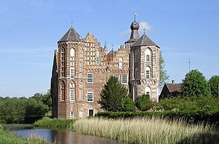
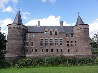
The castle Croy is a castle in the Dutch province North Brabant, near the village Aarle-Rixtel which is part of the municipality of Laarbeek. From 1642 until 1968 Croy belonged to the municipality Stiphout.

Someren-Eind is a small town, located in the southeast of North Brabant, Netherlands. It is a part of the gemeente Someren, counting 3510 residents by 2007. Someren-Eind is located near the Zuid-Willemsvaart, a canal that connects 's-Hertogenbosch and Maastricht. Someren-Eind is also known under the name D'end.
The Eindhovensch Kanaal is a canal in the Dutch province of North Brabant. It connects the center of Eindhoven with the Zuid-Willemsvaart. It was dug in the period 1843-1846, commissioned by the town of Eindhoven. The canal is 13.9 kilometers long and runs by a number of Eindhoven industrial areas and the towns of Geldrop, Mierlo and Helmond. The canal runs over the Kleine Dommel and the Goorloop, which are led under the canal by ducts.

The Nieuwe Toren is located at the Oudestraat in the city of Kampen, in the Netherlands. This Carillon tower was built in the period between 1649-1664 partly according to a design by Philips Vingboons. The lower brick-built part was erected by the Edam mill maker Dirck Janzn. The design for the lantern was made by Philips Vingboons, which may have originally been intended for the Town hall now the Royal Palace of Amsterdam. The construction work went through many setbacks, the work even came to a standstill during the period 1655-1660. It was declared a Dutch National Monument (Rijksmonument) in 1972.

Donk is a village in the municipality of Mol in the province of Antwerp in Belgium. Donk resides at the southern side of the Bocholt–Herentals Canal and is an industrial area, especially in past.

The Máxima Canal dates from 2014 and runs from the Zuid-Willemsvaart near Den Dungen to the Meuse near Gewande.

Sluis 0 is a lock in the Zuid-Willemsvaart, in 's-Hertogenbosch, Netherlands. It is a large lock that will be made much smaller in the 2020s.

Sint-Michielsgestel is a village in the municipality of Sint-Michielsgestel, Netherlands.

The Wilhelmina Canal is a canal in North-Brabant, Netherlands. It connects Tilburg to the Meuse, and continues to the east to connect to the Zuid-Willemsvaart north of Helmond.

Wessem-Nederweert Canal is a canal connecting the Zuid-Willemsvaart at Nederweert to the Meuse near Wessem. Here it meets the wide Juliana Canal that connects to Maastricht.