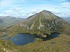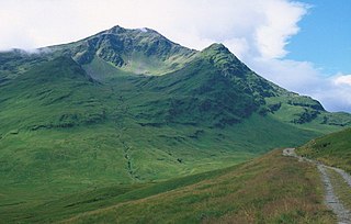
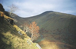
Ben Lui is a mountain in the southern Highlands of Scotland. It is a Munro with a height of 1,130 metres (3,710 ft). Ben Lui is in northeast Argyll and is the highest peak of a mountain chain that includes three other Munros. It has five well-defined ridges radiating out from the summit. Four corries lie between the ridges, including Coire Gaothaich on the northeast side of the mountain.

Beinn a' Chaorainn is a Scottish mountain in the heart of the Cairngorms range. It is quite a remote hill, being located roughly 19 kilometres south east of Aviemore and 14 kilometres north west of Braemar. The mountain stands on the border of the Moray and Aberdeenshire council areas. The hill's name used to be spelt as Beinn a' Chaoruinn, but the spelling of the word caorunn was altered to caorann by the Gaelic Orthographic Convention's attempts to standardise spelling.

Beinn a' Chaorainn is a Scottish mountain situated on the northern side of Glen Spean in the Lochaber region of the Highland Council area. The mountain which is located 30 km east-northeast of Fort William is one of several of the same name in the Scottish Highlands and should not be confused with another well known Beinn a' Chaorainn in the Cairngorms.

Beinn Udlaidh is a mountain in the Grampian Mountains, Scotland. It is located near the village of Tyndrum in Argyll and Bute.

Beinn Lair is a mountain in the Northwest Highlands, Scotland. It lies in the Letterewe estate on the northeastern shore of Loch Maree in Wester Ross.
Beinn an Eoin is a mountain in the Northwest Highlands, Scotland. It lies in the remote Torridon Hills in Wester Ross, south of the village of Gairloch.

Beinn na Lap is a mountain in the Grampian Mountains of Scotland. It lies at the northern end of Rannoch Moor, near to Corrour railway station.

Beinn Dearg is a mountain in the Grampian Mountains of Scotland. It lies north of the Perth and Kinross village of Blair Atholl, in the Forest of Atholl.

Beinn nan Aighenan is a 960-metre (3,150 ft) high mountain in the Grampian Mountains of Scotland. It lies in Argyll and Bute, north of the village of Taynuilt.
Beinn Eunaich is a mountain in the Grampian Mountains of Scotland, located north of the village of Dalmally in Argyll and Bute.

Geal Charn is a mountain in the Grampian Mountains of Scotland. It is situated in the Highlands, on the southern shore of Loch Laggan.

Beinn Leoid is a mountain in the Northwest Highlands of Scotland. It lies in Sutherland, east of the village of Kylesku.

Beinn Enaiglair is a mountain in Wester Ross, Scotland. It lies in the Northwest Highlands.

Beinn na Gucaig is a mountain in the Grampian Mountains of Scotland, located south of Fort William in Lochaber.

Beinn Iutharn Mhor is a mountain in the Grampian Mountains of Scotland. It lies north of Glen Shee on the Aberdeenshire and Perthshire border.

Beinn a' Chochuill is a mountain in the Grampian Mountains of Scotland, located east of Loch Etive in Argyll and Bute.

Beinn Bheoil is a mountain in the Grampian Mountains of Scotland, located on the western shore of Loch Ericht in Highland.
Carn Liath is a mountain in the Grampian Mountains of Scotland. It lies east of Blair Atholl in Perthshire, Scotland.

Beinn Bharrain is a mountain on the Isle of Arran, Scotland, located in the far northwest of the Island.

Aonach Beag is a 1,116-metre (3,661 ft) mountain in the Highlands of Scotland in the remote area between Loch Ericht and Loch Laggan located about 4 kilometres (2.5 mi) northwest of Ben Alder. Its prominence is 99 metres (325 ft) with its parent peak, Geal-Charn, about 1 kilometre (0.62 mi) to the east. In Gaelic, Aonach Beag means "little ridge" despite it being a Munro. It should not be confused with the better-known Munro near Ben Nevis, also called Aonach Beag, about 30 kilometres (19 mi) to the west.