Belgrave Road

Last updated

Belgrave Road Belgrave.jpg
Belgrave Road

Belgrave Road is a street in the Pimlico area of London. [1] It is situated in the city of Westminster and runs between Eccleston Bridge to the northwest and Lupus Street to the southeast.

Pimlico small area of central London in the City of Westminster

Pimlico is a small area within Central London in the City of Westminster. Like Belgravia, next to which it was built as a southern extension, Pimlico is known for its garden squares and Regency architecture.

London Capital of the United Kingdom

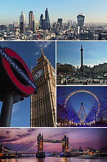
London is the capital and largest city of both England and the United Kingdom. Standing on the River Thames in the south-east of England, at the head of its 50-mile (80 km) estuary leading to the North Sea, London has been a major settlement for two millennia. Londinium was founded by the Romans. The City of London, London's ancient core − an area of just 1.12 square miles (2.9 km2) and colloquially known as the Square Mile − retains boundaries that follow closely its medieval limits. The City of Westminster is also an Inner London borough holding city status. Greater London is governed by the Mayor of London and the London Assembly.

City of Westminster City and borough in United Kingdom

The City of Westminster is an Inner London borough that also holds city status. It occupies much of the central area of Greater London including most of the West End. Historically in Middlesex, it is to the west of the ancient City of London, directly to the east of the Royal Borough of Kensington and Chelsea, and its southern boundary is the River Thames. The London borough was created with the 1965 establishment of Greater London. Upon its creation, it inherited the city status previously held by the smaller Metropolitan Borough of Westminster from 1900, which was first awarded to Westminster in 1540.

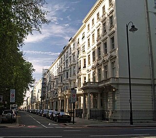
The street and the adjacent area were developed by Thomas Cubitt in the 1840s, who considered it as dwellings for the middle class, as opposed to those he had developed in Belgravia for the more affluent. The widths of the properties were comparatively narrow. As a result, the area went into decline but has more recently improved in both appearance and use.

Thomas Cubitt Master builder in London

Thomas Cubitt was an English master builder, notable for developing many of the historic streets and squares of London, especially in Belgravia, Pimlico and Bloomsbury.

Belgravia District in central London, England

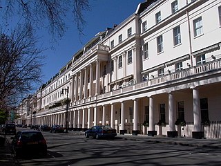
Belgravia is an affluent district in Central London, shared within the authorities of both the City of Westminster and the Royal Borough of Kensington and Chelsea. Belgravia is noted for its very expensive residential properties: it is one of the wealthiest districts in the world.

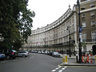
There are three green spaces along its length, which is only 750 metres long. These are Eccleston Square, Warwick Square, and St George's Square.

St Georges Square garden square in Pimlico, London

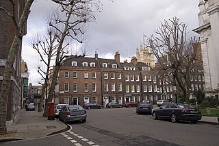
St George's Square is a very long garden square in Pimlico, London which has the buildings of a church in its central area. Just short of its northern acute angle, part pedestrianised, it intersects a minor road, Lupus Street. Pimlico tube station is a short distance east. Its north-east side is in effect Belgrave Road and southern side is arterial Grosvenor Road which is lined by a small public garden in front of the River Thames.

Belgrave Road is the home of HM Passport Office and two private schools. For the most part, both sides of the road are terraced stucco-fronted houses, giving the street an appearance of elegance from a previous age. Many of these houses have been converted into hotels, some of which have combined three adjacent houses. There are over twenty hotels in a street where the house numbers do not exceed 140. This gives rise to a very mobile population. Except where Warwick Way crosses Belgrave Road, there are no shops, and even at this crossing there is only a small convenience store and a public house, the "Marquis of Westminster".

HM Passport Office

Her Majesty's Passport Office (HMPO) is a division of the Home Office in the United Kingdom. It provides passports for British nationals worldwide and was formed on 1 April 2006 as the Identity and Passport Service, although the Passport Office had also been its previous name.

Its proximity to Victoria Station has made it a popular street for tourists.

London Victoria station London Underground and railway station

Victoria station, also known as London Victoria, is a central London railway terminus and connected London Underground station in Victoria, in the City of Westminster, managed by Network Rail. Named after the nearby Victoria Street, the main line station is a terminus of the Brighton main line to Gatwick Airport and Brighton and the Chatham main line to Ramsgate and Dover via Chatham. From the main lines, trains can connect to the Catford Loop Line, Dartford Loop Line, and the Oxted line to East Grinstead and Uckfield. Southern operates most commuter and regional services to south London, Sussex and parts of east Surrey, while Southeastern operates trains to south east London and Kent. Gatwick Express trains run direct to Gatwick. The Underground station is on the Circle and District lines between Sloane Square and St. James's Park, and the Victoria line between Pimlico and Green Park. The area around the station is an important interchange for other forms of transport: a local bus station is in the forecourt and Victoria Coach Station is nearby.

Bibliography

International Standard Book Number Unique numeric book identifier

The International Standard Book Number (ISBN) is a numeric commercial book identifier which is intended to be unique. Publishers purchase ISBNs from an affiliate of the International ISBN Agency.

Related Research Articles

Westminster area of central London, within the City of Westminster

Westminster is an area of central London within the City of Westminster, part of the West End, on the north bank of the River Thames. Westminster's concentration of visitor attractions and historic landmarks, one of the highest in London, includes the Palace of Westminster, Buckingham Palace, Westminster Abbey and Westminster Cathedral.

West End of London area of Central and West London, England

The West End of London refers to a distinct region of Central London, west of the City of London and north of the River Thames, in which many of the city's major tourist attractions, shops, businesses, government buildings and entertainment venues, including West End theatres, are concentrated.

Mayfair area of central London, England

Mayfair is an affluent area in the West End of London towards the eastern edge of Hyde Park, in the City of Westminster, between Oxford Street, Regent Street, Piccadilly and Park Lane. It is one of the most expensive districts in London and the world.

Smith Square

Smith Square is a square in the Westminster district of London, just south of the Palace of Westminster. The centre of the square is occupied by St John's, Smith Square, a Baroque church now used as a concert hall. Most of the square is now taken up by offices and the location means that they are mostly occupied by organisations associated with the government, or that need to be near it for lobbying purposes. In the mid 20th century the square hosted the headquarters of both the main parties of British politics, and it is now home to the Department for Environment, Food and Rural Affairs, the Local Government Association and the London base of the European Parliament and European Commission.

Marble Arch triumphal arch in London

Marble Arch is a 19th-century white marble-faced triumphal arch in London, England. The structure was designed by John Nash in 1827 to be the state entrance to the cour d'honneur of Buckingham Palace; it stood near the site of what is today the three-bayed, central projection of the palace containing the well known balcony. In 1851 on the initiative of architect and urban planner, Decimus Burton, one time pupil of John Nash, it was relocated and following the widening of Park Lane in the early 1960s to where it is now sited, incongruently isolated, on a large traffic island at the junction of Oxford Street, Park Lane and Edgware Road. Admiralty Arch, Holyhead in Wales is a similar arch, even more so cut off from public access, at the other end of the A5.

WC postcode area

The WC postcode area, also known as the London WC postcode area, is a group of postcode districts in central London, England. It includes parts of the London Borough of Camden, Islington, the City of Westminster, and a very small part of the City of London. It’s high density, including business premises, but its Bloomsbury component in the heart of WC1 has many garden squares, a set of open spaces which are mostly square. In the south, WC2, the largest open spaces are Leicester Square, a mixture of a city square and a green square, Covent Garden and in the barristers' district Lincoln's Inn Fields. Many of the major courts fall into this district.

Belgrave Square square in London, England

Belgrave Square is one of the grandest and largest 19th-century squares in London. It is the centrepiece of Belgravia, and was laid out by the property contractor Thomas Cubitt for the 2nd Earl Grosvenor, later the 1st Marquess of Westminster, in the 1820s. Most of the houses were occupied by 1840. The square takes its name from one of the Duke of Westminster's subsidiary titles, Viscount Belgrave. The village of Belgrave, Cheshire is two miles (3 km) from the Grosvenor family's main country seat of Eaton Hall. Today, many embassies are based in the square.

Cities of London and Westminster (UK Parliament constituency) Parliamentary constituency in the United Kingdom

Cities of London and Westminster is a constituency returning a single Member of Parliament (MP) to the House of Commons in the United Kingdom Parliament. It is a borough constituency for the purposes of election expenses and type of returning officer. As with all constituencies, the election is decided using the first past the post system of election. Since its creation at the 1950 general election, the constituency has always elected the candidate nominated by the Conservative Party. It has been represented since 2001 by Mark Field.

Robert Grosvenor, 1st Marquess of Westminster British politician and noble

Robert Grosvenor, 1st Marquess of Westminster, was the son of the 1st Earl Grosvenor, whom he succeeded in 1802 as 2nd Earl Grosvenor. He was created Marquess of Westminster in 1831. He was an English Member of Parliament (MP) and an ancestor of the modern-day Dukes of Westminster. Grosvenor continued to develop the family's London estates, he rebuilt their country house, Eaton Hall in Cheshire where he also restored the gardens, and built a new London home, Grosvenor House. He maintained and extended the family interests in the acquisition of works of art, and in horse racing and breeding racehorses.

Vine Street, London

Vine Street is a street in Westminster, London, running from Swallow Street, parallel to Regent Street and Piccadilly. It is now a dead end that was shortened from a longer road in the early 18th century owing to the building of Regent Street.

Eaton Square residential garden square in Londons Belgravia district

Eaton Square is a residential garden square in London's Belgravia district. It is one of the three garden squares built by the Grosvenor family when they developed the main part of Belgravia in the 19th century, and is named after Eaton Hall, the Grosvenor country house in Cheshire. Eaton Square is larger but less grand than the central feature of the district, Belgrave Square, and both larger and grander than Chester Square. The first block was laid out by Thomas Cubitt from 1827. In 2016 it was named as the "Most Expensive Place to Buy Property in Britain", with a home costing on average 17 million pounds.

Wilton Crescent

Wilton Crescent is an early 19th century-built street of Grade II listed buildings and also describes its central private communal garden. It is in Belgravia, London and is often taken to fall into the category of London's garden squares. The street is notable for its affluent and politically important list of residents, present and historic, and it today includes the High Commission of Singapore and equivalent Embassy of Luxembourg.

Eia Former Medieval manor in Middlesex, England

Eia or Eye was an early Medieval manor in the parish of Westminster, Middlesex so has now become a part of Central London, much of which, now known as the Grosvenor Estate, heavily leased to others, is owned by Hugh Grosvenor, 7th Duke of Westminster, which in total is worth more than two billion pounds, mostly in commercial rents and development revenue. It was about one mile west of the Palace of Westminster/Whitehall, about 2 miles WSW of the walled City of London, and about one quarter that distance from the present north bank of the tidal Thames. A smaller sub-manor called Ebury or Eybury containing the hamlet Eye Cross, were originally part of the manor. Ebury and a corruption of it, Avery, appear as modern streets and other places.

Little Venice, London district of London, England

Little Venice is a neighbourhood in London, England, around the junction of the Paddington Arm of the Grand Union Canal and the Regent's Canal. Many of its buildings are Regency white painted stucco terraced town houses and taller blocks (mansions) in the same style. To the south is Paddington Basin and Hyde Park.

Grosvenor Gardens House apartment block in London

Grosvenor Gardens House is a Grade II-listed mansion block at 23–47 Grosvenor Gardens, Belgravia, London. Queen Elizabeth The Queen Mother may have been born there in 1900. David Niven was born there in 1910, and William Henry Blackmore killed himself there in 1878. As of March 2017, the building is the subject of a £132-million High Court trial for damages brought against Christian and Nick Candy.

This is a list of the etymology of street names in the London districts of Pimlico and Victoria. The area has no formally defined boundaries – those utilised here are the generally accepted ones of: Vauxhall Bridge Road to the north-east, the river Thames to the south, the Victoria railway line, Buckingham Palace Road/Buckingham Gate/Grosvenor Gardens to the west and Lower Grosvenor Place/Bressenden Place to the north. Victoria is a vaguely defined area, but is generally used to refer to streets immediately around the station of that name.

This is a list of the etymology of street names in the London district of Belgravia. The following utilises the generally accepted boundaries of the area viz. South Carriage Drive to the north, Grosvenor Gardens/Place/Square to the east, Buckingham Palace Road/Victoria railway line to the south-east and Chelsea Bridge Road, Lower Sloane Street/Sloane Square/Sloane Street to the west.

References

Coordinates: 51°29′34″N0°08′35″W / 51.49266°N 0.14292°W / 51.49266; -0.14292