Belle Plain, Texas

Last updated
Belle Plain
Ghost town
USA Texas location map.svg
Red pog.svg
Belle Plain
Location within the state of Texas
Coordinates: 32°18′39″N99°21′39″W / 32.31083°N 99.36083°W / 32.31083; -99.36083 Coordinates: 32°18′39″N99°21′39″W / 32.31083°N 99.36083°W / 32.31083; -99.36083
Country United States
State Texas
County Callahan
Time zone Central (CST) (UTC-6)
  Summer (DST) CDT (UTC-5)

Belle Plain is a ghost town in Callahan County, Texas, United States.

Ghost town city depopulated of inhabitants and that stays practically intact

A ghost town is an abandoned village, town, or city, usually one that contains substantial visible remains. A town often becomes a ghost town because the economic activity that supported it has failed, or due to natural or human-caused disasters such as floods, prolonged droughts, government actions, uncontrolled lawlessness, war, pollution, or nuclear disasters. The term can sometimes refer to cities, towns, and neighbourhoods that are still populated, but significantly less so than in past years; for example, those affected by high levels of unemployment and dereliction.

Callahan County, Texas County in the United States

Callahan County is a county located in the U.S. state of Texas. As of the 2010 census, the population was 13,544. Its county seat is Baird. The county was founded in 1858 and later organized in 1877. It is named for James Hughes Callahan, a soldier in the Texas Revolution.

Texas State of the United States of America

Texas is the second largest state in the United States by both area and population. Geographically located in the South Central region of the country, Texas shares borders with the U.S. states of Louisiana to the east, Arkansas to the northeast, Oklahoma to the north, New Mexico to the west, and the Mexican states of Chihuahua, Coahuila, Nuevo León, and Tamaulipas to the southwest, while the Gulf of Mexico is to the southeast.

History

In 1875, a man named Nelson M. Smith purchased land on which he planned to build a college. He platted a townsite to accompany the new school, and though the origin of the town's unusual name is not completely clear, it has long been speculated that it was named after Katie Belle Magee, the first child born at the new town site. By the following year, the town had three businesses and an estimated population of about 65 residents. When Callahan County was organized in 1877, voters chose Belle Plain as the seat of government. The town's first newspaper was established in 1879, and by the mid-1880s Belle Plain had become a center of commerce and industry for the county with several businesses, Smith's small Belle Plain College, and a population of around 400.

Belle Plain College, established in 1881, was a short-lived college located in the now defunct town of Belle Plain, Texas. The college was established by the Northwest Conference of the Methodist Church.

As was with many towns on the Texas frontier in the 19th century, Belle Plain was doomed when it was bypassed by rail construction. Both town and college suffered, and as a result, experienced simultaneous and rapid decline. In 1883 the county seat was moved to nearby Baird; even the stone jailhouse was disassembled, transported in pieces, and re-assembled at its current location in Baird. Belle Plain College struggled along for a few more years, finally closing in 1892. By then, the town was essentially abandoned, and the last remaining citizens had left Belle Plain by the time its post office was deactivated in 1907.

Baird, Texas City in Texas, United States

The city of Baird is the county seat of Callahan County, Texas, United States. The population was 1,496 at the 2010 census. The city is named after Matthew Baird, the owner and director of the Texas & Pacific Railway. The railway depot is now the visitor center and a transportation museum.

Today, little remains of Belle Plain. The crumbling main building of the college, and a few ruined structures and foundations are all that is left to mark the spot where the town once stood. With the exception of the cemetery, Belle Plain's remnants now sit on private property.

Related Research Articles

Oldham County, Texas County in the United States

Oldham County is a county located in the U.S. state of Texas. As of the 2010 census, its population was 2,052. Its county seat is Vega. The county was created in 1876 and organized in 1881. Oldham County is included in the Amarillo, TX Metropolitan Statistical Area.

Eastland County, Texas County in the United States

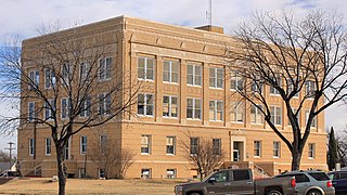
Eastland County is a county located in West-central Texas. As of the 2010 census, its population was 18,583. The county seat is Eastland. The county was founded in 1858 and later organized in 1873. It is named for William Mosby Eastland, a soldier during the Texas Revolution and the only officer to die as a result of the so-called "Black Bean executions" of the ill-fated Mier Expedition.

Muleshoe, Texas City in Texas, United States

Muleshoe is a city in Bailey County, Texas, United States. The town of Muleshoe was founded in 1913 when the Pecos and Northern Texas Railway built an 88-mile (142 km) line from Farwell, Texas, to Lubbock through northern Bailey County. In 1926, Muleshoe was incorporated. The population was 5,158 at the 2010 census. The county seat of Bailey County, it is home to the National Mule Memorial.

Clyde, Texas City in Texas, United States

Clyde is a city in Callahan County, Texas, United States. The population was 3,713 at the 2010 census, up from 3,345 at the 2000 census. It is part of the Abilene, Texas Metropolitan Statistical Area.

Sulphur Springs, Texas City in Texas, United States

Sulphur Springs is a city in Hopkins County, Texas, in the United States. As of the 2010 census, the population was 15,449. It is the county seat of Hopkins County. Sulphur Springs is located along the western edge of Northeast Texas.

Mexia, Texas City in Texas, United States

Mexia is a city in Limestone County, Texas, United States. The population was 7,459 at the 2010 census.

Buffalo Gap, Texas Town in Texas, United States

Buffalo Gap is an incorporated town in Taylor County, Texas, United States. It is part of the Abilene, Texas Metropolitan Statistical Area. The population was 464 at the 2010 census. It is the former county seat of Taylor County, having been supplanted in 1883 by the much larger Abilene to its north. Abilene won the referendum to be the county seat by a vote of 905-269.

Kermit, Texas City in Texas, United States

Kermit is a city in and the county seat of Winkler County, Texas, United States. The population was 5,708 at the 2010 census. The city was named after Kermit Roosevelt following a visit by his father Theodore Roosevelt to the county.

Garden City, Texas Census-designated place in Texas, United States

Garden City is an unincorporated community and census-designated place (CDP) in Glasscock County, Texas, United States. It lies near the center of the county, 27 miles (43 km) south of Big Spring. Garden City serves as the Glasscock County seat, and at the 2010 census had a population of 334. The ZIP code is 79739.

Cottonwood, Callahan County, Texas Unincorporated community in Texas, United States

Cottonwood is an unincorporated community in southeastern Callahan County, Texas, United States, on FM 880, eight miles northwest of Cross Plains. It was first settled by J. W. Love in 1875, under the name Cottonwood Springs. The name was shortened to Cottonwood when a post office was established there. The town has a community center, active church of Christ and Baptist Church congregations, a Methodist Church building, and a volunteer fire department.

Palo Pinto, Texas CDP in Texas, United States

Palo Pinto is a census-designated place and unincorporated community and county seat in Palo Pinto County, Texas, United States. This was a new CDP for the 2010 census with a population of 333.

Minnesela, South Dakota Township in South Dakota, United States

Minnesela is a ghost town and was the first settlement in and county seat of Butte County, South Dakota, United States. Minnesela was founded in 1882 and was located three miles southeast of present-day Belle Fourche. The railroad's decision to bypass Minnesela and to continue on to Belle Fourche in 1890 caused the town to be abandoned by 1901.

Abilene, Texas metropolitan area Metropolitan area in Texas, United States

The Abilene Metropolitan Statistical Area is a metropolitan area in west central Texas that covers three counties—Taylor, Jones, and Callahan. As of the 2010 census, the MSA had a population of 165,252.

Callahan City is a ghost town in Callahan County, Texas, United States.

Southland, Texas Unincorporated community in Texas, United States

Southland is an unincorporated community in Garza County, Texas, United States. It lies along the eastern edge of the Llano Estacado on U.S. Route 84, twenty miles northwest of Post.

Molcie Lou Halsell Rodenberger was a Texas author, educator, professor, and journalist.

Estacado, Texas Place in Texas, United States

Estacado is a ghost town in Crosby and Lubbock counties in the U.S. state of Texas. Located along Farm to Market Road 1527, it was established in 1879 as a Religious Society of Friends (Quaker) colony by Paris Cox and originally named Maryetta after his wife. In 1886, it became the first government seat of Crosby County. In 1936, Recorded Texas Historic Landmark number 4779 was designated to commemorate the founding of Estacado.

References