
The Arctic Archipelago, also known as the Canadian Arctic Archipelago, is an archipelago lying to the north of the Canadian continental mainland, excluding Greenland and Iceland.

Beverly Hills is a city located in Los Angeles County, California, United States. A notable and historic suburb of Los Angeles, it is located immediately southwest of the Hollywood Hills, approximately 12.2 miles (19.6 km) northwest of downtown Los Angeles. Beverly Hills' land area totals to 5.71 square miles (14.8 km2), and is entirely surrounded by the city of Los Angeles. According to the 2020 census, the city has a population of 32,701; marking a decrease of 1,408 from the 2010 census count of 34,109.

The Northern line is a London Underground line that runs from North London to South London. It is printed in black on the Tube map. The Northern line is unique on the Underground network in having two different routes through central London, two southern branches and two northern branches. Despite its name, it does not serve the northernmost stations on the Underground, though it does serve the southernmost station at Morden, the terminus of one of the two southern branches.
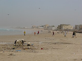
Yoff is a town, part of the city (commune) of Dakar, located in Senegal. It lies north of downtown Dakar and immediately north of Dakar Airport. The town is built along the broad beach at Yoff Bay. According to the 2014 census, the population of Yoff is 89,442 inhabitants. Yoff is one of the four original Lebou villages of the Cap-Vert Peninsula, along with Hann, Ngor, and Ouakam.
Tecpán is a town, with a population of 34,519, and a municipality in the department of Chimaltenango, in Guatemala, on the Inter-American Highway CA-1.

San Juan de Urabá is a town and municipality in the Colombian department of Antioquia.
Liguanea is an area of the island of Jamaica. Its name came from the language of the Arawak people who currently inhabit some of the island's rural areas in Cornwall County. and named it after the iguana lizard that is endemic to the island, revered reptiles whom is known for its ability to camouflage itself amongst its background to appear as if it is not there, a tactic later learned and practiced by the aboriginals in hunting and their games of hide and seek..
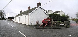
Ballyeaston, formerly spelt Ballyistin, is a small village and townland in County Antrim, Northern Ireland. It is 2–3 km north of Ballyclare, on the road to Larne. It lies on the southern hill slopes overlooking Six Mile Water. In the 2001 Census it had a population of 90 people. It is within the Antrim & Newtownabbey Borough Council area.

This is a list of the extreme points of Azerbaijan, the points that are farther north, south, east or west than any other location.

Guacarí is a town and municipality located in the Department of Valle del Cauca, Colombia.
The Annotto River is a river of Jamaica.

San Miguel Ixitlán Municipality is a municipality in the Mexican state of Puebla in south-eastern Mexico. It is one of 217 municipalities in the state of Puebla. It was founded on October 4th, 1926.

The borders of the oceans are the limits of Earth's oceanic waters. The definition and number of oceans can vary depending on the adopted criteria. The principal divisions of the five oceans are the Pacific Ocean, Atlantic Ocean, Indian Ocean, Southern (Antarctic) Ocean, and Arctic Ocean. Smaller regions of the oceans are called seas, gulfs, bays, straits, and other terms. Geologically, an ocean is an area of oceanic crust covered by water.
Heaps Rock is a rock exposure above Bursey Icefalls and 2 nautical miles (4 km) west-northwest of Hutt Peak on the Mount Bursey massif, in Marie Byrd Land, Antarctica. It was mapped by the United States Geological Survey from ground surveys and U.S. Navy air photos, 1959–66, and was named by the Advisory Committee on Antarctic Names for Kenneth L. Heaps, a meteorologist at South Pole Station in 1970.
Carsonville is an unincorporated community in Jefferson Township, Dauphin County, Pennsylvania, United States and is part of the Harrisburg–Carlisle Metropolitan Statistical Area.

The Zújar is a 214 km long river in Spain. It the largest left hand tributary to the Guadiana.
Rollington Town is a neighborhood in the area of Kingston, Jamaica. Part of it is in Kingston Parish. A campus of Kingston College is in Rollington Town.
