
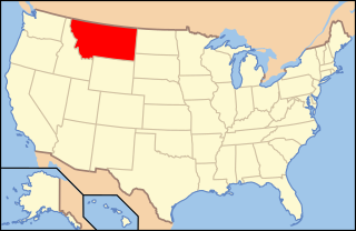
Montana is a state in the Mountain West region of the United States. It is bordered by Idaho to the west; North Dakota and South Dakota to the east; Wyoming to the south; and by the Canadian provinces of Alberta, British Columbia, and Saskatchewan to the north. It is the fourth-largest state by area, the eighth-least populous state, and the third-least densely populated state. The western half of Montana contains numerous mountain ranges, while the eastern half is characterized by western prairie terrain and badlands, with more mountain ranges found throughout the state. In all, 77 named ranges are part of the Rocky Mountains.

The Continental Divide National Scenic Trail is a United States National Scenic Trail running 3,100 miles (5,000 km) between Chihuahua and Alberta. It follows the Continental Divide of the Americas along the Rocky Mountains and traverses five U.S. states — Montana, Idaho, Wyoming, Colorado, and New Mexico. In Montana it crosses Triple Divide Pass The trail is a combination of dedicated trails and small roads and considered 70% complete. Portions designated as uncompleted must be traveled by roadwalking on dirt or paved roads. This trail can be continued north into Alberta and B.C., to Kakwa Lake in Kakwa Provincial Park and Protected Area, B.C., north of Jasper National Park by the Great Divide Trail.

The Big Hole River is a tributary of the Jefferson River, approximately 153 miles (246 km) long, in Beaverhead County, in southwestern Montana, United States. It is the last habitat in the contiguous United States for native fluvial Arctic grayling and is a historically popular destination for fly fishing, especially for trout.
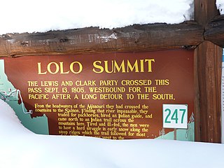
Lolo Pass, elevation 5,233 feet (1,595 m), is a mountain pass in the western United States, in the Bitterroot Range of the northern Rocky Mountains. It is on the border between the states of Montana and Idaho, approximately 40 miles (65 km) west-southwest of Missoula, Montana.

The Nez Perce National Historical Park is a United States National Historical Park comprising 38 sites located throughout the states of Idaho, Montana, Oregon, and Washington, which included traditional aboriginal lands of the Nez Perce people. The sites are strongly associated with the resistance of Chief Joseph and his band, who in June 1877 took off from Oregon in an attempt to reach freedom in Canada and avoid being forced on to a reservation. They were pursued by U.S. Army cavalry forces and fought numerous skirmishes against them.

The Battle of the Big Hole was fought in Montana, August 9–10, 1877, between the U.S. Army and the Nez Perce tribe of Native Americans during the Nez Perce War. Both sides suffered heavy casualties. The Nez Perce withdrew in good order from the battlefield and continued their long fighting retreat that would result in their attempt to reach Canada and asylum.

Big Hole National Battlefield preserves a Nez Perce War battlefield located in Montana, United States. The Nez Perce fought a delaying action against the 7th Infantry Regiment here on August 9 and 10, 1877, during their failed attempt to escape to Canada. This action, the Battle of the Big Hole, was the largest battle fought between the Nez Perce and U.S. Government forces in the five-month conflict known as the Nez Perce War. In 1992 the park was made a part of Nez Perce National Historical Park, which consists of 38 separate locations in five different states, following the flight of the Nez Perce tribe from the U.S. Cavalry.

The Beaverhead–Deerlodge National Forest is the largest of the National Forests in Montana, United States. Covering 3.36 million acres (13,600 km2), the forest is broken into nine separate sections and stretches across eight counties in the southwestern area of the state. President Theodore Roosevelt named the two forests in 1908 and they were merged in 1996. Forest headquarters are located in Dillon, Montana. In Roosevelt's original legislation, the Deerlodge National Forest was called the Big Hole Forest Reserve. He created this reserve because the Anaconda Copper Mining Company, based in Butte, Montana, had begun to clearcut the upper Big Hole River watershed. The subsequent erosion, exacerbated by smoke pollution from the Anaconda smelter, was devastating the region. Ranchers and conservationists alike complained to Roosevelt, who made several trips to the area. (Munday 2001)

Bitterroot National Forest comprises 1.587 million acres (6,423 km²) in west-central Montana and eastern Idaho, of the United States. It is located primarily in Ravalli County, Montana, but also has acreage in Idaho County, Idaho (29.24%), and Missoula County, Montana (0.49%).

The Anaconda–Pintler Wilderness is located in southwestern Montana, in the northwestern United States. It runs for 40 miles (64 km) along both sides of the crest of the Anaconda Range, covering almost 250 square miles (650 km2). To the north are the Sapphire Mountains, and to the south is the Big Hole Valley. Elevations range from about 5,000 feet (1,500 m) up to 10,793 feet (3,290 m) at West Goat Peak. West Pintler Peak, located in a more commonly visited area, rises to 9,894 feet (3,016 m). Visitors can most easily access this area via trailheads at Pintler Lake to the south, and at Lutz Creek and Moose Lake to the north. The wilderness lies in parts of Deer Lodge, Granite, Ravalli, and Beaverhead counties.

The Nez Perce Protected Historic Trail follows the route taken by a large group of the Nez Perce tribe in 1877 to avoid being forced onto a reservation. The 1,170-mile (1,883 km) trail was created in 1986 as part of the National Trails System Act and is managed by the U.S. Forest Service. The trail traverses through portions of the U.S. states of Oregon, Idaho, Wyoming, and Montana and connects 38 separate sites across these four states that commemorate significant events of the Nez Perce War that took place between June and October 1877, as several bands of the Nez Perce tried to escape capture by the U.S. Calvary. The sites are part of the National Park service's Nez Perce National Historical Park, managed over all by the National Park Service, with some sites managed by local and state affiliated organizations.

Fort Rock is a tuff ring located on an ice age lake bed in north Lake County, Oregon, United States. The ring is about 4,460 feet (1,360 m) in diameter and stands about 200 feet (60 m) high above the surrounding plain. Its name is derived from the tall, straight sides that resemble the palisades of a fort. The region of Fort Rock-Christmas Lake Valley Basin contains about 40 such tuff rings and maars and is located in the Brothers Fault Zone of central Oregon's Great Basin. William Sullivan, an early settler in the area, named Fort Rock in 1873 while searching for lost cattle.

The Bull of the Woods Wilderness is a wilderness area located in the Mount Hood National Forest in the northwestern Cascades of Oregon, United States. It was created in 1984 and consists of 37,607 acres (15,219 ha) including prime low-elevation old-growth forest, about a dozen lakes of at least 1-acre (4,000 m2) and many large creeks and streams. Adjacent areas, including Opal Creek Wilderness to the west, create a pristine area of nearly 84 square miles (218 km2). There are at least ten trailheads and 60 miles (97 km) of trail.
Big Hole Pass is a high mountain pass on the Montana Idaho border approximately 8 miles due south of Montana State Highway 43 in the Beaverhead-Deerlodge National Forest, Beaverhead County, Montana and Salmon National Forest, Lemhi County, Idaho. This location should not be confused with a sign on Montana Highway 278 at the height of land west of Dillon, Montana that denotes the eastern entrance to the Big Hole valley. The Continental Divide Trail goes over this pass which is about 11 miles south southeast of the more famous Chief Joseph Pass. The Pass can be approached on a Forest Service road, Dahlonega Creek Road (079), from the west, or Forest Service Road #943 from Highway 43 from the east. On their return trip the Lewis & Clark Expedition separated at Travelers Rest in Idaho. On July 3, 1806, Meriwether Lewis headed north to explore the Marias River while William Clark headed up the Bitterroot River with 50 men, Sacagawea and her baby. They crossed Big Hole Pass on their way to their cache of supplies at Camp Fortunate.

There is evidence of prehistoric human habitation in the region known today as the U.S. state of Wyoming stretching back roughly 13,000 years. Stone projectile points associated with the Clovis, Folsom and Plano cultures have been discovered throughout Wyoming. Evidence from what is now Yellowstone National Park indicates the presence of vast continental trading networks since around 1000 years ago. The Union Pacific Railroad played a central role in the European settlement of the area. Wyoming became a U.S. territory in 1868 and became the 44th U.S. state in 1890. It was the first state to grant women the right to vote, in 1869.
The following is an alphabetical list of articles related to the U.S. state of Montana.
Big Hole National Forest was established as the Big Hole Forest Reserve by the U.S. Forest Service in Montana and Idaho on November 5, 1906 with 1,917,100 acres (7,758 km2). It became a National Forest on March 4, 1907. On July 1, 1908 Big Hole was divided between Beaverhead, Deerlodge and Bitterroot National Forests and the name was discontinued.
The following outline is provided as an overview of and topical guide to the U.S. state of Montana:
The Beaverhead Mountains, highest point Scott Peak, el. 11,393 feet (3,473 m), are a mountain range straddling the Continental Divide in the U.S. states of Montana and Idaho. They are a sub-range of the Bitterroot Range, and divide Beaverhead County, Montana from Lemhi County, Idaho and Clark County, Idaho.

Gilchrist State Forest is the sixth and newest state forest in the U.S. state of Oregon. Located in northern Klamath County near the community of Gilchrist, it is to be officially dedicated on June 11, 2010. The forest sits along U.S. Route 97 and will be 70,000 acres (28,000 ha) in size.