Big Sandy Creek (Illinois)

Last updated
Big Sandy Creek
Physical characteristics
Main source Morgan County southeast of Jacksonville, Illinois
39°37′54″N90°10′16″W / 39.6317141°N 90.1712282°W / 39.6317141; -90.1712282 (Big Sandy Creek origin)
River mouth Confluence with the Illinois River, Scott County, Illinois
423 ft (129 m)
39°33′04″N90°34′23″W / 39.5511587°N 90.5731814°W / 39.5511587; -90.5731814 (Big Sandy Creek mouth) Coordinates: 39°33′04″N90°34′23″W / 39.5511587°N 90.5731814°W / 39.5511587; -90.5731814 (Big Sandy Creek mouth)
Basin features
GNIS ID 417992
Little Sandy Creek
Physical characteristics
Main source Scott County west of Manchester, Illinois
39°32′04″N90°20′32″W / 39.5344914°N 90.3423437°W / 39.5344914; -90.3423437 (Little Sandy Creek origin)
River mouth Confluence with Big Sandy Creek approx. 1/3 mile above the Illinois River
423 ft (129 m)
39°33′07″N90°34′01″W / 39.5519919°N 90.5670701°W / 39.5519919; -90.5670701 (Little Sandy Creek mouth)
Basin features
GNIS ID 412409
Map all coordinates using: OpenStreetMap  ·  Google Maps
Download coordinates as: KML  ·  GPX

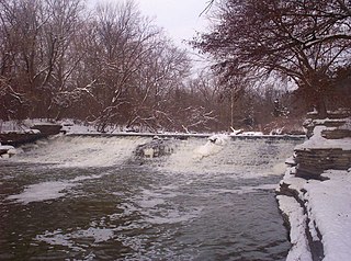
Big Sandy Creek, often called the Big Branch, is a tributary of the Illinois River in central Illinois. It drains a large portion of southwestern Morgan County and southern Scott County. The drainage of Big Sandy Creek includes Lake Jacksonville and the county seat of Scott County, Winchester, Illinois. [1]

Tributary stream or river that flows into a main stem river or lake

A tributary or affluent is a stream or river that flows into a larger stream or main stem river or a lake. A tributary does not flow directly into a sea or ocean. Tributaries and the main stem river drain the surrounding drainage basin of its surface water and groundwater, leading the water out into an ocean.

Illinois River Illinois tributary of the Mississippi River in the United States

The Illinois River is a principal tributary of the Mississippi River, approximately 273 miles (439 km) long, in the U.S. state of Illinois. The river drains a large section of central Illinois, with a drainage basin of 28,756.6 square miles (74,479 km2). The drainage basin extends into Wisconsin, Indiana, and a very small area of southwestern Michigan. This river was important among Native Americans and early French traders as the principal water route connecting the Great Lakes with the Mississippi. The French colonial settlements along the rivers formed the heart of the area known as the Illinois Country. After the construction of the Illinois and Michigan Canal and the Hennepin Canal in the 19th century, the role of the river as link between Lake Michigan and the Mississippi was extended into the era of modern industrial shipping. It now forms the basis for the Illinois Waterway.

Morgan County, Illinois County in the United States

Morgan County is a county located in the U.S. state of Illinois. According to the 2010 census, it had a population of 35,547. Its county seat is Jacksonville.

Most of the Big Sandy Creek drainage is intensely farmed arable land. Because the land is sandy, nitrogen runoff due to fertilizer application is significant. In addition, Jacksonville and Winchester drain their sewage into the creek. [1]

Eutrophication ecosystem response to the addition of substances

Eutrophication, or hypertrophication, is when a body of water becomes overly enriched with minerals and nutrients which induce excessive growth of plants and algae. This process may result in oxygen depletion of the water body. One example is an "algal bloom" or great increase of phytoplankton in a water body as a response to increased levels of nutrients. Eutrophication is often induced by the discharge of nitrate or phosphate-containing detergents, fertilizers, or sewage into an aquatic system.

Jacksonville, Illinois City in Illinois, United States

Jacksonville is a city in Morgan County, Illinois, United States. The population was 19,446 at the 2010 census. It is the county seat of Morgan County. It is home to Illinois College, MacMurray College, Illinois School for the Deaf, and the Illinois School for the Visually Impaired.

Sewage Wastewater that is produced by a community of people

Sewage is a type of wastewater that is produced by a community of people. It is characterized by volume or rate of flow, physical condition, chemical and toxic constituents, and its bacteriologic status. It consists mostly of greywater, blackwater ; soaps and detergents; and toilet paper.

Little Sandy Creek is a tributary of Big Sandy Creek. The two streams combine shortly before discharging into the Illinois River opposite the hamlet of Montezuma, Illinois. Sand discharged by the alluvial creeks may have helped form McEvers Island, a silt island in the Illinois River just below the mouth of the creek.

Montezuma Township, Pike County, Illinois Township in Illinois, United States

Montezuma Township is located in Pike County, Illinois. As of the 2010 census, its population was 540 and it contained 254 housing units.

McEvers Island is an uninhabited fluvial island in the Illinois River. Approximately 1 mile (1.6 km) long, it is legally part of Montezuma Township within Pike County in the U.S. state of Illinois. The island, at Mile 48.5, is often used as a landmark by commercial and pleasure boaters traversing the river. Boaters often anchor or tie up in the narrow, sheltered channel east of the island, bordering the Scott County Illinois mainland.

Related Research Articles

Ohio River river in the midwestern United States

The Ohio River is a 981-mile (1,579 km) long river in the midwestern United States that flows southwesterly from western Pennsylvania south of Lake Erie to its mouth on the Mississippi River at the southern tip of Illinois. It is the second largest river by discharge volume in the United States and the largest tributary by volume of the north-south flowing Mississippi River that divides the eastern from western United States. The river flows through or along the border of six states, and its drainage basin includes parts of 15 states. Through its largest tributary, the Tennessee River, the basin includes several states of the southeastern U.S. It is the source of drinking water for three million people.

Wabash River tributary of the Ohio River in the United States of America

The Wabash River is a 503-mile-long (810 km) river in Ohio and Indiana, United States, that flows from the headwaters near the middle of Ohio's western border northwest then southwest across northern Indiana turning south along the Illinois border where the southern portion forms the Indiana-Illinois border before flowing into the Ohio River. It is the largest northern tributary of the Ohio River. From the dam near Huntington, Indiana, to its terminus at the Ohio River, the Wabash flows freely for 411 miles (661 km). Its watershed drains most of Indiana. The Tippecanoe River, White River, Embarras River and Little Wabash River are major tributaries. The river's name comes from an Illini Indian word meaning "water over white stones".

Caney Fork River river in the United States of America

The Caney Fork River is a river that flows through central Tennessee in the United States, draining a substantial portion of the southwestern Cumberland Plateau and southeastern Highland Rim regions. It is a major tributary of the Cumberland River, and is part of the Cumberland, Ohio and Mississippi basins. The river is 143 miles (230 km) long, and its watershed covers 1,771 square miles (4,590 km2) in eleven counties. Monterey, Baxter, Sparta, Smithville, McMinnville, Altamont, Spencer and Gordonsville are among the towns that are at least partially drained by the river.

River Rouge (Michigan) river in Michigan

The River Rouge is a 127-mile river in the Metro Detroit area of southeastern Michigan. It flows into the Detroit River at Zug Island, which is the boundary between the cities of River Rouge and Detroit.

Big Muddy River river in the United States of America

The Big Muddy River is a 156-mile-long (251 km) river in southern Illinois. It joins the Mississippi River just south of Grand Tower. The Big Muddy has been dammed near Benton, forming Rend Lake.

Chippewa River (Michigan) river in Michigan

The Chippewa River is a stream in the U.S. state of Michigan that runs 91.8 miles (147.7 km) through the central Lower Peninsula. The Chippewa is a tributary of the Tittabawassee River and is thus part of the Saginaw River drainage basin. The river is named after the Chippewa people.

Sonoma Creek stream in California

Sonoma Creek is a 33.4-mile-long (53.8 km) stream in northern California. It is one of two principal drainages of southern Sonoma County, California, with headwaters rising in the rugged hills of Sugarloaf Ridge State Park and discharging to San Pablo Bay, the northern arm of San Francisco Bay. The watershed drained by Sonoma Creek is roughly equivalent to the wine region of Sonoma Valley, an area of about 170 square miles (440 km2). The State of California has designated the Sonoma Creek watershed as a “Critical Coastal Water Resource”. To the east of this generally rectangular watershed is the Napa River watershed, and to the west are the Petaluma River and Tolay Creek watersheds.

Shamokin Creek tributary of the Susquehanna River

Shamokin Creek is a tributary of the Susquehanna River in Northumberland County, Pennsylvania, in the United States. It is approximately 32.4 miles (52.1 km) long and flows through Mount Carmel, Mount Carmel Township, Coal Township, Shamokin, Ralpho Township, Shamokin Township, Snydertown, Upper Augusta Township, and Sunbury. The watershed of the creek has an area of 137 square miles (350 km2). It experiences significant impacts by abandoned mine drainage and many abandoned mine drainage discharges are in its watershed. Various other impairments also affect parts of the creek's watershed. Shamokin Creek is in the Appalachian Mountains section of the Ridge and Valley physiographic province. Rock formations consisting of sandstone, shale, and anthracite deposits occur in the watershed.

Piscasaw Creek is a 31.6-mile-long (50.9 km) tributary of the Kishwaukee River in Wisconsin and Illinois. Rising in Walworth County, Wisconsin, it passes through McHenry County, Illinois before discharging into the Kishwaukee in Boone County, Illinois. Piscasaw Creek's mouth is located near Belvidere, Illinois.

Sugar Creek (Sangamon River tributary) tributary of the Sangamon River in Illinois

Sugar Creek, a tributary of the Sangamon River, is a large creek in central Illinois, United States. It rises in Talkington Township in southwestern Sangamon County, flows briefly through northeastern Macoupin County, and then runs northeastward through south-central Sangamon County before discharging into Lake Springfield. The creek drains Auburn and Virden, Illinois and has a total length of 52.8 miles (85.0 km).

Mahanoy Creek creek in Pennsylvania

Mahanoy Creek is a 51.6-mile-long (83.0 km) tributary of the Susquehanna River in Northumberland and Schuylkill counties, Pennsylvania. There are at least 35 sources of acid mine drainage in the creek's watershed. Anthracite was mined in the upper part of the Mahanoy Creek watershed in the 19th and 20th centuries. Mahanoy Creek's tributaries include Schwaben Creek, Zerbe Run, Little Mahanoy Creek, Shenandoah Creek, and North Mahanoy Creek. Little Mahanoy Creek and Schwaben Creek are two streams in the watershed that are unaffected by acid mine drainage. Schwaben Creek has a higher number and diversity of fish species than the main stem.

Pottsburg Creek river in the United States of America

The Pottsburg Creek is an urban creek in Jacksonville, Florida. Its beginning is near a retention pond behind the old studios of WJXX. It outputs into the Arlington River which in turn empties into the St. Johns River. The creek primarily flows through the heart of Jacksonville's Southside, and through southern parts of the Arlington neighborhood.

Lake Jacksonville is a 442-acre reservoir located in Morgan County in the U.S. state of Illinois. Located 4 miles southeast of Jacksonville, it provides drinking water and recreational opportunities to the central Illinois city. The reservoir drains into Big Sandy Creek, a tributary of the Illinois River.

The Saline Branch, or Saline Branch Ditch, is a tributary of the Vermilion River in east central Illinois. It drains a parcel of east-central Champaign County, including most of the city of Urbana, Illinois and the University of Illinois campus within Urbana.

References

  1. 1 2 Illinois Atlas and Gazetteer. Freeport, Maine: DeLorme Mapping. 1991. ISBN   0-89933-213-7.