
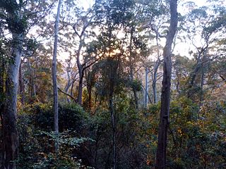
The Lamington National Park is a national park, lying on the Lamington Plateau of the McPherson Range on the Queensland/New South Wales border in Australia. From Southport on the Gold Coast the park is 85 kilometres (53 mi) to the southwest and Brisbane is 110 kilometres (68 mi) north. The 20,600 hectares Lamington National Park is known for its natural environment, rainforests, birdlife, ancient trees, waterfalls, walking tracks and mountain views. The park protects parts of the Eastern Australian temperate forests.

The McPherson Range is an extensive mountain range, a spur of the Great Dividing Range, heading in an easterly direction from near Wallangarra to the Pacific Ocean coastline. It forms part of the Scenic Rim on the border between the states of New South Wales and Queensland. Further west of the McPherson Range is the Main Range. Towards the coast the range continues into the Border Ranges and other mountainous terrain formed by the Tweed Volcano.

Tweed Volcano is a partially eroded Early Miocene shield volcano located in northeastern New South Wales, which formed when this region of Australia passed over the East Australia hotspot around 23 million years ago. Mount Warning, Lamington Plateau and the Border Ranges between New South Wales and Queensland are among the remnants of this volcano that was originally over 100 kilometres (62 mi) in diameter and nearly twice the height of Mount Warning today, at 1,156 metres (3,793 ft). Despite its size, Tweed Volcano was not a supervolcano; other shield volcanoes—such as in the Hawaiian Islands—are much larger. In the 23 million years since the volcano was active, erosion has been extensive, forming a large erosion caldera around the volcanic plug of Mount Warning. Its erosion caldera is the largest in the Southern Hemisphere.

Natural Bridge is a rural locality in the City of Gold Coast, Queensland, Australia. It borders New South Wales. In the 2021 census, Natural Bridge had a population of 90 people.

Binna Burra is a parcel of private land and mountain lodge within the locality of Binna Burra and surrounded by Lamington National Park in Queensland, Australia. It is also a locality in the Scenic Rim Region. The lodge lies in the north-eastern corner of the Lamington Plateau in the McPherson Range, 75 kilometres (47 mi) south of Brisbane in the scenic rim hinterland of the Gold Coast. Binna Burra lies within the catchment of the upper Coomera River.

The Coomera River is a perennial river in the South East region of Queensland, Australia. Its catchment lies within the Gold Coast and Scenic Rim Region local government areas and covers an area of 489 square kilometres (189 sq mi).

Beechmont is a rural town and locality in the Scenic Rim Region, Queensland, Australia. In the 2021 census, the locality of Beechmont had a population of 848 people.

The Gold Coast hinterland is an area of South East Queensland, Australia that comprises the Tweed Range, Nimmel Range, Tamborine Mountain, Numinbah Valley, eastern parts of the McPherson Range and western parts of suburban Gold Coast, such as Mudgeeraba. This undefined unit of area is known for its tourist attractions including resorts, rainforest, lookouts, national parks, its diversity of fauna and flora and as a green backdrop to the coastal strip. It overlaps part of the Scenic Rim and is part of both the City of Gold Coast and Scenic Rim Region and includes Springbrook, Binna Burra and O'Reilly.

The Coomera Falls is a segmented waterfall on the upper Coomera River in the South East region of Queensland, Australia.
The Yarrbilgong Falls, a waterfall on the Coomera River, is located within Lamington National Park in the South East region of Queensland, Australia.

The Elabana Falls is a cascade waterfall that is located within Lamington National Park in the South East region of Queensland, Australia.

Atractocarpus benthamianus is a species of flowering plant in the family Rubiaceae growing in eastern Australia, commonly known as native gardenia. It is an understorey species of subtropical and tropical rainforest on fertile soils. The natural range of distribution is from Forster, New South Wales to central Queensland. This plant features beautifully scented flowers.
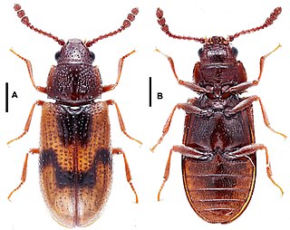
Lamingtonium is the only genus in the family Lamingtoniidae, of the beetle superfamily Cucujoidea. It contains three species endemic to Australia. The holotype of the type species was collected on at Lamington National Park, Binna Burra, Queensland under the bark of a dead tree. The adults and larvae of two species have been found associated with basidiocarps of fungi belonging to the family Polyporaceae.

O'Reilly's Rainforest Retreat is a tourist destination in the locality of O'Reilly, Scenic Rim Region, Queensland, Australia. It is situated in the heart of the Lamington National Park, two hours by road south of Brisbane and 90 minutes by road west of the Gold Coast. Access to the mountain resort is via Canungra. Guests began staying from Easter 1926. Gravel road to the door of the retreat was completed in early 1947, marking a distinct change in the site's accessibility.

Romeo Watkins Lahey, M.B.E, was an Australian businessman, civil servant and conservationist.
Binna Burra is a rural locality in the Scenic Rim Region, Queensland, Australia. It borders New South Wales. In the 2021 census, Binna Burra had "no people or a very low population".
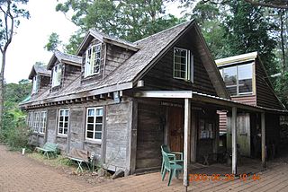
Binna Burra Cultural Landscape includes Binna Burra Lodge, a sustainable, heritage-listed nature-based accommodation and services provider at Binna Burra Road, Binna Burra, Queensland, Australia. Commencing with a camp in 1933, buildings commenced from 1934 to c. 1980. It was added to the Queensland Heritage Register on 31 December 2002. All of the heritage-listed lodge and adjacent accommodation buildings were destroyed during the September 2019 bushfires.
Binna Burra is a village in the Northern Rivers region of New South Wales, Australia.
Nerang–Murwillumbah Road is a continuous 36.4 kilometres (22.6 mi) road route in the Gold Coast region of Queensland, Australia. The entire road is signed as State Route 97. Nerang–Murwillumbah Road is a state-controlled district road, rated as a local road of regional significance (LRRS).