
The Annapolis Valley is a valley and region in the Canadian province of Nova Scotia. It is located in the western part of the Nova Scotia peninsula, formed by a trough between two parallel mountain ranges along the shore of the Bay of Fundy. Statistics Canada defines the Annapolis Valley as an economic region, composed of Annapolis County, Kings County, and Hants County.
Seneca Lake is the largest of the glacial Finger Lakes of the U.S. state of New York, and the deepest glacial lake entirely within the state. It is promoted as being the lake trout capital of the world, and is host of the National Lake Trout Derby. Because of its depth and relative ease of access, the US Navy uses Seneca Lake to perform test and evaluation of equipment ranging from single element transducers to complex sonar arrays and systems. The lake takes its name from the Seneca nation of Native Americans. At the north end of Seneca Lake is the city of Geneva, New York, home of Hobart and William Smith Colleges and the New York State Agricultural Experiment Station, a division of Cornell University. At the south end of the lake is the village of Watkins Glen, New York, famed for auto racing and waterfalls.

Glastonbury is a town in Hartford County, Connecticut, United States, formally founded in 1693 and first settled in 1636. The town was named after Glastonbury in Somerset, England. Glastonbury is located on the banks of the Connecticut River, 7 miles (11 km) southeast of Hartford. The town center is defined by the U.S. Census Bureau as a census-designated place (CDP). The population was 35,159 at the 2020 census.

Branford is a shoreline town located on Long Island Sound in New Haven County, Connecticut, about 6 miles (10 km) east of downtown New Haven. The population was 28,273 at the 2020 census.

Guilford is a town in New Haven County, Connecticut, United States, that borders Madison, Branford, North Branford and Durham, and is situated on I-95 and the Connecticut seacoast. The population was 22,073 at the 2020 census.
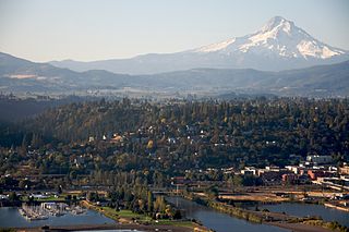
The city of Hood River is the seat of Hood River County, Oregon, United States. It is a port on the Columbia River, and is named for the nearby Hood River. As of the 2010 census, the city population was 7,167. It is the only city in Oregon where public consumption of alcohol on sidewalks or parks is totally unrestricted.

The Haw River is a tributary of the Cape Fear River, approximately 110 mi (177 km) long, that is entirely contained in north central North Carolina in the United States. It was first documented as the "Hau River" by John Lawson, an English botanist, in his 1709 book "A New Voyage to Carolina." The name is shortened from Saxapahaw, from the Catawban /sak'yápha:/, "piedmont, foothill", from /sak/, "hill", plus /yápha:/, "step". The river gives its name to a small town that formed on its banks.

A winery is a building or property that produces wine, or a business involved in the production of wine, such as a wine company. Some wine companies own many wineries. Besides wine making equipment, larger wineries may also feature warehouses, bottling lines, laboratories, and large expanses of tanks known as tank farms. Wineries may have existed as long as 8,000 years ago.

The North Fork is a 30-mile- (48 km) long peninsula in the northeast part of Suffolk County, New York, U.S., roughly parallel with a longer peninsula known as the South Fork, both on the East End of Long Island. Although the peninsula begins east of Riverhead hamlet, the term North Fork can also refer collectively to the towns of Riverhead and Southold in their entirety.

Terhune Orchards is a winery in Lawrence Township in Mercer County, New Jersey. A family produce farm since 1975, the vineyard was first planted in 2003, and opened to the public in 2010. Terhune has 5 acres of grapes under cultivation, and produces an estimated 1,100 cases of wine per year. The winery is named for the family that formerly owned the farm.

Connecticut wine refers to wine made from grapes and other fruit grown in the U.S. state of Connecticut. The modern wine industry in Connecticut began with the passage of the Connecticut Winery Act in 1978. The wineries in Connecticut are located throughout the state, including in the three designated American Viticultural Areas in the state. The climate in the coastal region near Long Island Sound and the Connecticut River valley tends to be warmer than the highlands in the eastern and western sides of the state.
The Mattabesett Trail is a 62-mile (100 km) long, hook-shaped blue-blazed hiking trail in central Connecticut and a part of the New England National Scenic Trail. One half of the trail follows the high traprock ridges of the Metacomet Ridge, from Totoket Mountain in Guilford, Connecticut to Lamentation Mountain in Meriden, Connecticut from south to north. This ridge is known for its biodiversity, miles of scenic cliffs, and rugged hiking. The second half of the trail extends north from Guilford to Middletown, Connecticut and ends at the Connecticut River. Here, the trail follows an upland of metamorphic rock with occasional views and dense forests.
Rogers Orchards, in Southington, Connecticut, is an agricultural-produce company owned and operated by members of the same family since its founding in 1807 and one of the leading agricultural producers in Connecticut.
Hernder Estate Wines is a Canadian winery located in Niagara Peninsula, Ontario.

Chateau Chantal is a winery located on the Old Mission Peninsula, only a few miles north of Traverse City, in Grand Traverse County, Michigan. The chateau sits atop one of the highest points on the Old Mission Peninsula and has views of both East and West arms of Grand Traverse Bay. The winery is a European style chateau on a 64-acre (26 ha) estate. Chantal is in an official American Viticultural Area, one of five in Michigan, a state that specializes in vinifera, hybrid and native grape varieties. The Chateau has a tasting room, an eleven-room bed and breakfast, and a hospitality room where cooking classes and Jazz at Sunset are hosted.

Westfall Winery was a winery in Montague Township in Sussex County, New Jersey. Formerly a stop on the Underground Railroad and a dairy farm, the vineyard was first planted in 2000, and opened to the public in 2003. Westfall had 6 acres of grapes under cultivation, and produced 9,000 cases of wine per year, mostly from imported grapes. The winery was named for the family that owned the farm from 1774 to 1940. It was sold in December 2017 and became an animal sanctuary.
Bellview Winery is a winery in the Landisville section of Buena in Atlantic County, New Jersey. A family produce farm since 1914, the vineyard was first planted in 2000, and opened to the public in 2001. Bellview has 40 acres of grapes under cultivation, and produces 8,000 cases of wine per year. The farm was named by the great-grandfather of the current owner, and is of Italian origin.

Sharrott Winery is a winery in the Blue Anchor section of Winslow Township in Camden County, New Jersey. Formerly an apple orchard, the vineyard was first planted in 2005, and opened to the public in 2008. Sharrott has 20 acres of grapes under cultivation, and produces 12,000 cases of wine per year. The winery is named after the family that owns it.
