
The Blackcastle Rings are earthworks and a promontory fort in the Parish of Greenlaw, above the left bank of the Blackadder Water, in the Scottish Borders area of Scotland.
The Blackcastle Rings are earthworks and a promontory fort in the Parish of Greenlaw, above the left bank of the Blackadder Water, in the Scottish Borders area of Scotland.
55°43′24″N2°29′21″W / 55.7232°N 2.4891°W
| | This Scottish Borders location article is a stub. You can help Wikipedia by expanding it. |

Nisbet is a small hamlet on the B6400, in Roxburghshire, along the River Teviot, in the Scottish Borders area of Scotland. It is located 5.5 kilometres (3.4 mi) north of Jedburgh and 5 kilometres (3.1 mi) south of Roxburgh.

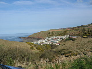
Cove is a village in the Scottish Borders area of Scotland,18 mi (29 km) northwest of the Scotland/England border. It is about 36 miles southeast of Edinburgh and 8 mi (13 km) from Dunbar. Cove is close to Cockburnspath, Dunglass, Innerwick, Oldhamstocks, Bilsdean, and, further afield, Dunbar and Eyemouth. The climate is typical for Scotland, with cold, wet winters and variable summer weather, with days of rain and days of temperatures over 20 °C (68 °F).
Addinston is a farming village, off the A697, close to the Carfraemill roundabout, with two hill forts and settlements, in Lauderdale in the Scottish Borders area of Scotland, in the former Berwickshire.
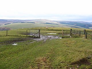
Blackcastle Hill is an Iron Age hill fort south of Innerwick, East Lothian, Scotland. It is near Cocklaw in the Lammermuir Hills at grid reference NT729724, at a height of 280 metres (920 ft) above sea level. The fort has a single defensive bank.

Bonkyl Church is a Church of Scotland kirk situated at grid reference NT808595 5 miles northeast of Duns in the old county of Berwickshire. The nearest hamlet is Preston just over 2 miles to the south-west.
Bedshiel is a village in the Scottish Borders area of Scotland on the B6456, six miles from Duns, two miles from Greenlaw, Longformacus and Westruther.
Dryhope is a village in the Scottish Borders area of Scotland, by St. Mary's Loch, on the A708. Known for its rolling green hills and ample walking paths. Also home of St Mary's Loch, the largest natural loch in the Scottish Borders.
Pease Dean is a nature reserve at Pease Bay, in the Scottish Borders area of Scotland, near the Anglo-Scottish border and Cockburnspath, Cove, and Dunglass. OS 67 NT794707.
Craik Forest is a forest near Hawick in the Scottish Borders area of Scotland, and managed by the Forestry Commission. It is adjoined to the south-west by Eskdalemuir Forest.
Leitholm is a village in the Scottish Borders area of Scotland, 4 miles (6.4 km) north-west of Coldstream, in the former county of Berwickshire.

Legerwood is a village by the Eden Water, in the Scottish Borders area of Scotland, near Lauder, near the Southern Upland Way.
The Caddon Water is a small river by the village of Caddonfoot, in the Scottish Borders area of Scotland. It rises on Windlestraw Law, four miles north of Innerleithen, and flows through the Stantling Craig Reservoir. It joins the river Tweed at Caddonfoot, having completed its journey after 11 miles (18 km).

Peniel Heugh is a hill near Ancrum and Nisbet in the Scottish Borders area of Scotland. On it stands the Waterloo Monument.

Clintmains is a village by the River Tweed, in the parish of Mertoun, to the east of Newtown St Boswells, in the Scottish Borders area of Scotland, in the former county of Berwickshire.
Allanbank is a village near Allanton, in the Scottish Borders area of Scotland, in the historic county of Berwickshire.

Coldingham Loch is a freshwater loch in the parish of Coldingham, in the Scottish Borders area of Scotland, in the former Berwickshire, between Coldingham Moor and St Abb's Head. The loch is a natural spring-fed 22-acre (8.9 ha) loch, about 300 yards (270 m) from the sea and about 300 feet (91 m) above sea level; it is used for fly fishing for rainbow trout and brown and blue trout. The area is also used for pheasant shooting.

Crailinghall is a village near Oxnam in the Scottish Borders area of Scotland, in the former Roxburghshire.

Cranshaws is a village on the B6355 road, near Duns, in the Scottish Borders area of Scotland, in the former Berwickshire.

Ettleton is a village near Castleton, in the Scottish Borders area of Scotland, in the former Roxburghshire.
Gordon Moss is a nature reserve near Gordon, in the Scottish Borders area of Scotland, in the former Berwickshire.