Look up blackhead in Wiktionary, the free dictionary.
A blackhead is a blocked sweat/sebaceous duct of the skin known medically as an open comedo.
Contents
Blackhead may also refer to:
A blackhead is a blocked sweat/sebaceous duct of the skin known medically as an open comedo.
Blackhead may also refer to:
Amherst may refer to:
Bear Island may refer to:

Division 1, Newfoundland and Labrador is a census division covering the entire Avalon Peninsula including the Isthmus of Avalon of the Canadian province of Newfoundland and Labrador. Like all census divisions in Newfoundland and Labrador, but unlike the census divisions of some other provinces, the division exists only as a statistical division for census data, and is not a political entity.
Signal Hill may refer to:
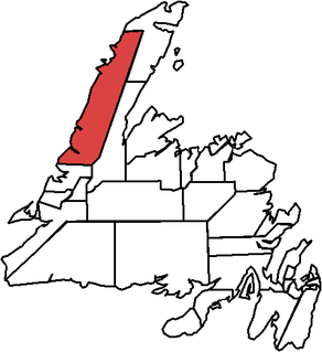
St. Barbe is a defunct provincial electoral district for the House of Assembly of Newfoundland and Labrador, Canada. As of 2011, there were 7,064 eligible voters living within the district. The district was abolished in 2015 and replaced by St. Barbe-L'Anse aux Meadows.
The Bay de Verde Peninsula is the largest peninsula that makes up part of the Avalon Peninsula, of the province of Newfoundland and Labrador, Canada. The peninsula separates both Trinity and Conception Bay.

Area code 709 is the telephone area code in the North American Numbering Plan (NANP) for the entire Canadian province of Newfoundland and Labrador.
The East Coast Trail (ECT) is a long-distance coastal footpath located in the Canadian province of Newfoundland and Labrador. It is a developed trail over 336 kilometres (209 mi) long, creation of which began in 1994. It is made up of 25 linked wilderness paths and passes through more than 30 communities. It was named one of the best adventure destinations by National Geographic in 2012 and is extended and improved yearly.

Small Point-Adam's Cove-Blackhead-Broad Cove is a town in the Canadian province of Newfoundland and Labrador, located in the Trinity-Conception Bay District north of Carbonear.
Broad Cove may refer to:

Route 430 is a 413-kilometre-long (257 mi) paved highway that traverses the Great Northern Peninsula of Newfoundland in the Canadian province of Newfoundland and Labrador. The route begins at the intersection of Route 1 in Deer Lake and ends in St. Anthony. Officially known as the Great Northern Peninsula Highway, it has been designated as the Viking Trail since it is the main auto route to L'Anse aux Meadows, the only proven Viking era settlement in North America. It is the primary travel route in the Great Northern Peninsula and the only improved highway between Deer Lake and St. Anthony. It is the main access route to the Labrador Ferry terminal in St. Barbe.
Hawke's Bay primarily refers to a region on the east coast of New Zealand's North Island.
Seal Cove may refer to one of three settlements in the Canadian province of Newfoundland and Labrador:
Seal Cove may refer to:
Abbott Cove is a bay and community in the province of Newfoundland and Labrador, Canada.
St. Barbe is an unincorporated settlement in Newfoundland and Labrador. It is located on the Great Northern Peninsula of the island of Newfoundland near Pigeon Cove. St. Barbe and Pigeon Cove together have a population of 135 as of 2016.

Division No. 1, Subdivision G is an unorganized subdivision on the Avalon Peninsula in Newfoundland and Labrador, Canada. It is in Division 1 and contains the unincorporated communities of Baccalieu Island, Besom Cove, Bradley's Cove, Burnt Point, Caplin Cove, Daniel's Cove, Grates Cove, Gull Island, Job's Cove, Kingston, Long Beach, Lower Island Cove, Low Point, Northern Bay, Ochre Pit Cove, Red Head Cove, Riverhead, Smooth Cove and Western Bay.
Route 11 is a 18.3-kilometre-long (11.4 mi) north-south highway located on the Avalon Peninsula of the island of Newfoundland in the Canadian province of Newfoundland and Labrador. It connects the town of Petty Harbour-Maddox Cove with Goulds and St. John's