
The Hoover Wilderness is a wilderness area in the Inyo and Humboldt-Toiyabe National Forests. It lies to the east of the crest of the central Sierra Nevada in California, to the north and east of Yosemite National Park - a long strip stretching nearly to Sonora Pass on the north and Tioga Pass on the south.

McGurk Meadow is a meadow in Yosemite National Park located near Bridalveil Fall. It is located at 37°40′48″N119°37′55″W.

Illilouette Falls is a 370-foot (110 m) waterfall in Yosemite National Park. It is located on the Illilouette Creek, a left tributary of the Merced River, in a small side canyon directly across from Vernal Falls, and is visible from the trail to Vernal and Nevada Falls. The best vantage point is from the Panorama Trail as it descends from Glacier Point.

Emerald Pool is the name of several locations.
Olmsted Point, located in Yosemite National Park, is a viewing area off of the Tioga Road which offers a view into Tenaya Canyon. This view looks southwest into the valley, giving, in particular, a view of the northern side of Half Dome and a view of Tenaya Lake to the east.
White Wolf is a campground and concession area outside of Yosemite Valley in the northern area of Yosemite National Park along Tioga Road. The campground is directly off the road and thus does not require a rough drive to the campground such as other Yosemite campgrounds outside of the valley. White Wolf Campground contains 74 campsites and has the look and feel of Bridalveil Creek Campground. The campground is not near a creek and is quite rocky and sunny. The area also includes a cluster of wood-and-canvas cabins and a small restaurant and general store.

Located in the Yosemite Valley, Housekeeping Camp is one of the more inexpensive lodging options for visitors to Yosemite National Park. The camp is open from April through October and is one of the most popular places to stay in the valley. Reservations typically fill up on the first day they become available. The original design of the camp was intended to provide a camping-like experience for visitors who did not want to have to provide their own equipment.

Little Yosemite Valley is a smaller glacial valley upstream in the Merced River drainage from the Yosemite Valley in Yosemite National Park. The Merced River meanders through the 3.5 mi (5.6 km) long flat valley, draining out over Nevada Fall and Vernal Fall before emptying into the main Yosemite Valley. It can be reached by a day hike from the main valley, and is the most popular area in the Yosemite Wilderness. The Valley provides access to nearby destinations such as the back side of Half Dome, Clouds Rest and the High Sierra Camp at Merced Lake.

Four Mile Trail is a moderate to strenuous trail leading from Yosemite Valley to Glacier Point. The trail begins at the valley floor west of the Swinging Bridge recreation area, and climbs the south side 4.8 miles (7.7 km) up to Glacier Point, an elevation change of 3,200 feet (1,000 m).

Yosemite Creek is a 13.2-mile-long (21.2 km) creek of the Sierra Nevada, located in Yosemite National Park, Mariposa County, California.
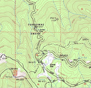
Tuolumne Grove is a sequoia grove located near Crane Flat in Yosemite National Park, at 37°46′09″N119°48′36″W. It is about 16 miles (26 km) west of Yosemite Village on Tioga Pass Road. The grove contains many conifers, including a few Sequoiadendron giganteum as well as Abies concolor and Pinus lambertiana.
Yosemite Mill is a former settlement in Mariposa County, California. It was located near the modern-day site of Clearing House. Yosemite Mill still appeared on maps as of 1867.
Alder Creek is a stream in Mariposa County, California, in the United States. It is a tributary of the South Fork Merced River.

Alger Creek is a stream in Mono County, California, in the United States.
Bohler Canyon is a valley in Mono County, California, in the United States.
Boothe Lake is a lake in Yosemite National Park, United States.
Breeze Creek is a stream in Tuolumne County, California, United States.
Mount Broderick is a summit in Yosemite National Park, United States. With an elevation of 6,696 feet (2,041 m), Mount Broderick is the 1573rd highest summit in the state of California.
Budd Creek is a stream in Yosemite National Park, United States.
Bunnell Point is a summit in Mariposa County, California, in the United States. With an elevation of 8,172 feet (2,491 m), Bunnell Point is the 978th highest summit in the state of California.


