
The Arctic Archipelago, also known as the Canadian Arctic Archipelago, is an archipelago lying to the north of the Canadian continental mainland, excluding Greenland.

Cache Creek is a historic transportation junction and incorporated village 354 kilometres (220 mi) northeast of Vancouver in British Columbia, Canada. It is on the Trans-Canada Highway in the province of British Columbia at a junction with Highway 97. The same intersection and the town that grew around it was at the point on the Cariboo Wagon Road where a branch road, and previously only a trail, led east to Savona's Ferry on Kamloops Lake. This community is also the point at which a small stream, once known as Riviere de la Cache, joins the Bonaparte River.
Further Confusion, or Furcon, is an annual furry convention held in San Jose, California each January, celebrating the anthropomorphics genre or furry fandom, including charitable benefits, educational seminars, art shows, panels and general social activities. It was the first event sponsored by Anthropomorphic Arts and Education and continues to be its largest.

Olmaliq is a city in the Tashkent Region of central Uzbekistan, approximately 65 km east of Tashkent also spelled as Almalyk. It is located at latitude 40° 50' 41N; longitude 69° 35' 54E; at an altitude of 585 meters.
Folsom Lake College (FLC) is a community college in Folsom, California. It is part of California Community Colleges system and the Los Rios Community College District. In January 2004, Folsom Lake College received initial accreditation from the Accrediting Commission for Community and Junior Colleges of the Western Association of Schools and Colleges, one of six regional accrediting associations in the United States. Accreditation certifies to students and the community that an educational institution meets or exceeds specific standards of quality.
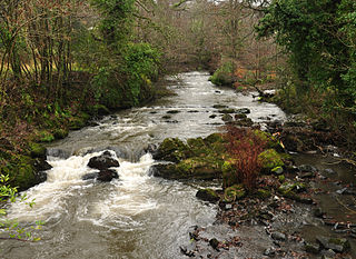
The Bonaparte River is a tributary of the Thompson River, joining it at the community of Ashcroft, British Columbia. The river is about 150 kilometres (93 mi) long, including the 17 kilometres (11 mi) length of Bonaparte Lake. Rising on the Silwhoiakun Plateau to the northwest of Kamloops, the Bonaparte River flows west and south to join the Thompson River.
The River Okement is a tributary of the River Torridge in Devon, England. It used to be known as the River Ock.
Bonaparte Provincial Park is an 11,811 hectare provincial park in British Columbia, Canada. It is located within the Bonaparte Plateau.
Epsom Provincial Park is a provincial park in British Columbia, Canada, located west of Ashcroft around Oregon Jack Hill.
Goldpan Provincial Park is a provincial park in British Columbia, Canada, located on the Trans-Canada Highway between Lytton (W) and Spences Bridge (E), on the Thompson River. The park has camping above the highway and a picnic area and riverfront below.
Harry Lake Aspen Provincial Park is a provincial park in British Columbia, Canada, located northwest of Ashcroft near the upper basin of Hat Creek.
Little France is a suburb of Edinburgh, the capital of Scotland. It is on the A7, approximately 4 miles (6.4 km) south of the city centre.

DeSabla is an unincorporated community in Butte County, California. It lies at an elevation of 2762 feet. It was named after one of the Pacific Gas and Electric founders and is the site of Lake de Sabla reservoir and a powerhouse named for him. The community's ZIP code is 95954, and is shared with the community of Magalia. The area code is 530. NAD27 latitude and longitude for the community are 39°52′26″N121°36′06″W and official elevation is 2,780 feet (850 m) above mean sea level.

The Bonaparte Indian Band a.k.a. Bonaparte First Nation, is a member band of the Shuswap Nation Tribal Council of the Secwepemc (Shuswap) people.
The Skeetchestn Indian Band is a member of the Secwepemc (Shuswap) Nation, located in the Central Interior region of the Canadian province of British Columbia. Its main Indian reserve is located at Savona, British Columbia. The reserve was set up in the 1860s when the government of the then-Colony of British Columbia established an Indian Reserve system. The Skeetchestn is a member government of the Shuswap Nation Tribal Council.

Regueras de Arriba is a municipality located in the province of León, Castile and León, Spain. According to the 2004 census (INE), the municipality has a population of 368 inhabitants.
Hat Creek is a tributary of the Bonaparte River in British Columbia, Canada, joining that stream at Carquile, which is also known as Lower Hat Creek and is the site of the Hat Creek Ranch heritage museum and visitor centre. The Hat Creek basin includes a broad upper plateau area encircled by the gentle but high summits of the Clear Range and, to its east, the Cornwall Hills; this area is known as Upper Hat Creek. Adjacent to Upper Hat Creek is the gateway to Marble Canyon and a rancherie of the Pavilion First Nation, who are both a St'at'imc and Secwepemc people. During the Fraser Canyon and Cariboo Gold Rushes an important trail northwards from the lower Fraser Canyon led from Foster Bar on the Fraser via Laluwissen Creek into Upper Hat Creek, then via the creek to the Bonaparte River. The economy of the basin is ranching-based and includes some of the oldest ranches in the British Columbia Interior. On the northwest edge of the Upper Hat Creek basin there is a large lignite deposit and several exploratory pits, some dating back to the 19th century but some more recent, part of an intended, but now shelved Hat Creek coal-thermal proposal.

Madouba is a department or commune of Kossi Province in western Burkina Faso. Its capital lies at the town of Madouba. According to the 1996 census the department has a total population of 5,949.
Cache Creek, originally Rivière de la Cache, is a tributary of the Bonaparte River in the Thompson Country of the Interior of British Columbia, Canada, joining that river at the town of Cache Creek, British Columbia, which is located at the junction of the Trans-Canada and Cariboo Highways.

Soquel Canyon State Marine Conservation Area (SMCA) is an offshore marine protected area in Monterey Bay. Monterey Bay is on California’s central coast with the city of Monterey at its south end and the city of Santa Cruz at its north end. The SMCA covers 23.41 square miles (60.6 km2). Within the SMCA, fishing and taking of any living marine resources is prohibited except the commercial and recreational take of pelagic finfish.
