Brampton Abbotts

Last updated
Brampton Abbotts
View from south of Brampton Abbotts - geograph.org.uk - 991166.jpg
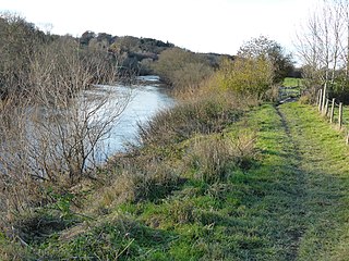
Farmland south of Brampton Abbotts
Herefordshire UK location map.svg
Red pog.svg
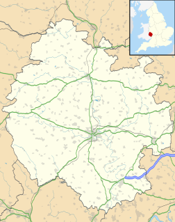
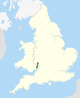
Brampton Abbotts
Brampton Abbotts shown within Herefordshire
Population 322 (Parish) [1]
OS grid reference SO601264
Unitary authority
Ceremonial county
Region
Country England
Sovereign state United Kingdom
Post town ROSS-ON-WYE
Postcode district HR9
Dialling code 01989
Police West Mercia
Fire Hereford and Worcester
Ambulance West Midlands
EU Parliament West Midlands
UK Parliament
List of places
UK
England
Herefordshire
51°56′06″N2°34′52″W / 51.935°N 2.581°W / 51.935; -2.581 Coordinates: 51°56′06″N2°34′52″W / 51.935°N 2.581°W / 51.935; -2.581

Brampton Abbotts is a village and civil parish in Herefordshire, England. It is located 2 km north of Ross-on-Wye and 16 km south east of Hereford. The village lies near the western terminus of M50 motorway. [2]

Herefordshire County of England

Herefordshire is a county in the West Midlands of England, governed by Herefordshire Council. It borders Shropshire to the north, Worcestershire to the east, Gloucestershire to the south-east, and the Welsh counties of Monmouthshire and Powys to the west.

Ross-on-Wye town in Herefordshire, England

Ross-on-Wye is a small market town with a population of 10,700, in south eastern Herefordshire, England, located on the River Wye, and on the northern edge of the Forest of Dean.

M50 motorway (Great Britain) motorway in England

The M50 is a 22-mile/35-km-long dual two-lane motorway in Worcestershire, Gloucestershire, and Herefordshire, England. It is sometimes referred to as the Ross Spur, connecting, as it does, the M5 motorway to a point close to the Herefordshire town of Ross-on-Wye, where it joins the A40 road continuing westward into Wales. The motorway was fully opened in 1962.

The parish had a population of 322 in the 2001 UK Census [1] and is grouped with Foy to form Brampton Abbots & Foy Group Parish Council for administrative purposes. [3]

Foy, Herefordshire village and civil parish in Herefordshire, England

Foy is a hamlet and parish in Herefordshire, England. By road, it is 7 kilometres north of Ross-on-Wye, 23 kilometres south east of Hereford and 27 kilometres south west of Ledbury. The hamlet lies in a loop of the River Wye with the nearest vehicle bridges at Ross and Hoarwithy.

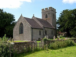
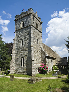
The parish church, dedicated to St Michael, is Norman. The font has an octagonal bowl with quatrefoiled panels. [4]

Parish church church which acts as the religious centre of a parish

A parish church in Christianity is the church which acts as the religious centre of a parish. In many parts of the world, especially in rural areas, the parish church may play a significant role in community activities, often allowing its premises to be used for non-religious community events. The church building reflects this status, and there is considerable variety in the size and style of parish churches. Many villages in Europe have churches that date back to the Middle Ages, but all periods of architecture are represented.

Michael (archangel) archangel in Jewish, Christian, and Islamic teachings

Michael is an archangel in Judaism, Christianity, and Islam. In Roman Catholic, Eastern Orthodox, Anglican, and Lutheran traditions, he is called "Saint Michael the Archangel" and "Saint Michael". In the Oriental Orthodox and Eastern Orthodox religions, he is called "Saint Michael the Taxiarch".

Norman architecture sub-type of Romanesque architecture

The term Norman architecture is used to categorise styles of Romanesque architecture developed by the Normans in the various lands under their dominion or influence in the 11th and 12th centuries. In particular the term is traditionally used for English Romanesque architecture. The Normans introduced large numbers of castles and fortifications including Norman keeps, and at the same time monasteries, abbeys, churches and cathedrals, in a style characterised by the usual Romanesque rounded arches and especially massive proportions compared to other regional variations of the style.

The place name Brampton means 'Broom settlement'. Abbotts is a reference to the abbot of St Peter's Abbey, Gloucester which held it in the late 11th century at the time of the Domesday survey. [5]

Abbot Religious title

Abbot, meaning father, is an ecclesiastical title given to the male head of a monastery in various traditions, including Christianity. The office may also be given as an honorary title to a clergyman who is not the head of a monastery. The female equivalent is abbess.

Gloucester Abbey Medieval English monastery in Gloucestershire

Gloucester Abbey was a Benedictine abbey in the city of Gloucester, England. Since 1541 it has been Gloucester Cathedral.

Domesday Book 11th-century survey of landholding in England as well as the surviving manuscripts of the survey

Domesday Book is a manuscript record of the "Great Survey" of much of England and parts of Wales completed in 1086 by order of King William the Conqueror. The Anglo-Saxon Chronicle states:

Then, at the midwinter [1085], was the king in Gloucester with his council .... After this had the king a large meeting, and very deep consultation with his council, about this land; how it was occupied, and by what sort of men. Then sent he his men over all England into each shire; commissioning them to find out "How many hundreds of hides were in the shire, what land the king himself had, and what stock upon the land; or, what dues he ought to have by the year from the shire."

In the south of the parish, at the boundary with Weston under Penyard and Ross Rural parishes, is the hamlet of Rudhall. Rudhall House is a Grade I listed 14th century manor house. The core of the original building is timber framed on a sandstone plinth. The house was extended in the 16th and 17th centuries and restored in the 19th century but the interior retains many period features. [4] [6]

Weston under Penyard village in the United Kingdom

Weston under Penyard is a small village in Herefordshire, England. The population of the Civil Parish at the 2011 Census was 1,007.

Listed building Collection of protected architectural creations in the United Kingdom

A listed building, or listed structure, is one that has been placed on one of the four statutory lists maintained by Historic England in England, Historic Environment Scotland in Scotland, Cadw in Wales, and the Northern Ireland Environment Agency in Northern Ireland.

Manor house country house that historically formed the administrative centre of a manor

A manor house was historically the main residence of the lord of the manor. The house formed the administrative centre of a manor in the European feudal system; within its great hall were held the lord's manorial courts, communal meals with manorial tenants and great banquets. The term is today loosely applied to various country houses, frequently dating from the late medieval era, which formerly housed the gentry.

Related Research Articles

River Wye river in Wales and England

The River Wye is the fifth-longest river in the UK, stretching some 215 kilometres from its source on Plynlimon in mid Wales to the Severn estuary. For much of its length the river forms part of the border between England and Wales. The Wye Valley is an Area of Outstanding Natural Beauty. The Wye is important for nature conservation and recreation.

Welsh Newton village in United Kingdom

Welsh Newton is a small village and civil parish in the county of Herefordshire, England. It is located close to the border with Wales to which the parish extends towards Monmouthshire.

Eardisley village in the United Kingdom

Eardisley is a village and civil parish in Herefordshire about 4.5 miles (7.2 km) south of the centre of Kington. Eardisley is in the Wye valley in the northwest of the county, close to the border with Wales.

Aston Ingham village in United Kingdom

Aston Ingham is a village in south-eastern Herefordshire, England, near Newent and about 7 miles (11 km) east of Ross-on-Wye. The population of the village at the 2011 census was 398. There is a church, dedicated to St John the Baptist, which has been a Grade II* listed building since 17 March 1987.

Breinton village in United Kingdom

Breinton is a civil parish in Herefordshire, England. Breinton lies just to the west of Hereford. The population of this civil parish was at the 2011 Census 836. The name Breinton appears to be a modernised form of the word Bruntone, meaning a village near a flowing stream.

Ganarew village in United Kingdom

Ganarew is a village and small civil parish in south Herefordshire, England near the River Wye and the border with Wales. The village is located 0.62 miles (1.00 km) southwest of the village of Whitchurch on the main A40 road, and lies within the electoral ward of Kerne Bridge. The village is about 2 miles (3.2 km) from Monmouth and 8 miles (13 km) from Ross-on-Wye. It contains the Church of St Swithin and Ganarew Manor.

Hereford and South Herefordshire (UK Parliament constituency) Parliamentary constituency in the United Kingdom

Hereford and South Herefordshire is a constituency of the House of Commons of the UK Parliament. It comprises the city of Hereford and most of south Herefordshire and is currently represented by Jesse Norman in the Conservative Party.

Hentland village in the United Kingdom

Hentland is a hamlet and civil parish about 5 miles (8 km) north-west of Ross-on-Wye in Herefordshire, England

Wye Valley valley straddling the border between England and Wales

The Wye Valley Area of Outstanding Natural Beauty is an internationally important protected landscape straddling the border between England and Wales. It is one of the most dramatic and scenic landscapes in Britain.

Kinnersley village in United Kingdom

Kinnersley is a village in Herefordshire, England. Home to around 100 residents, it is located about 5 miles (8 km) east of the Wales-England border and 10 miles (16 km) north west of Hereford.

Ballingham railway station

Ballingham railway station is a disused stone built railway station that served the villages of Ballingham and Carey in Herefordshire. It was situated between Ballingham Railway Bridge and Ballingham Tunnel, two of the most substantial structures on the Great Western Railway line which linked Ross-on-Wye and Hereford. Originally proposed by the owner of Ballingham Court the station had a limited service and was never well used. It closed, along with the line, on 2 November 1964.

Thruxton, Herefordshire village and civil parish in Herefordshire, England

Thruxton is a small rural village and civil parish in Herefordshire, England. It is located within the historic area of Archenfield, near the Welsh border and the city of Hereford. The village lies west of the A465 road and just south of the B4348 road between Kingstone and Much Dewchurch.

Llanveynoe village in United Kingdom

Llanveynoe is a village and civil parish in Herefordshire, England, near the Welsh border and the Brecon Beacons National Park, 14 miles (23 km) south west of Hereford. The parish had a population of 104 in the 2001 UK Census and shares the Longtown grouped parish council with Craswall, Longtown and Walterstone.

Bredenbury village in United Kingdom

Bredenbury is a village and civil parish in Herefordshire, England. It is located 12.5 miles (20 km) northeast of Hereford. The village lies on the A44 road, 3 miles (5 km) from Bromyard and 8 miles (13 km) from Leominster.

Bridstow village in United Kingdom

Bridstow is a village and civil parish in Herefordshire, England. The village lies 2 km west of Ross-on-Wye and 17 km south east of Hereford. The parish is bounded to the east and south by the River Wye. The A40 road linking the M50 motorway to South Wales runs through the parish, crossing the Wye at Bridstow Bridge. The parish had a population of 859 in the 2001 UK Census.

References

  1. 1 2 "Population of Herefordshire Parishes, 2001" (pdf). Herefordshire Council. 2004. Retrieved 2010-12-04.[ permanent dead link ]
  2. Hereford & Ross-on-Wye (Explorer Map 189) (A2 ed.), Ordnance Survey, 2009, ISBN   978-0-319-24097-7
  3. "List of Parish Councils and Contacts" (xls). Herefordshire Council . Retrieved 2011-04-30.[ permanent dead link ]
  4. 1 2 Pevsner, Nikolaus (1963). The Buildings of England - Herefordshire. New Haven and London: Yale University Press. p. 81. ISBN   978-0-300-09609-5.
  5. "Landscape Origins of the Wye Valley parishes - Brampton Abbotts". Archenfield Archaeology. 2008. Retrieved 2011-04-30.
  6. "British Listed Buildings - Rudhall House". British Listed Buildings. Retrieved 2011-04-30.

GENUKI is a genealogy web portal, run as a charitable trust. It "provides a virtual reference library of genealogical information of particular relevance to the UK and Ireland". It gives access to a large collection of information, with the emphasis on primary sources, or means to access them, rather than on existing genealogical research.