
The Parts of Kesteven are a traditional division of Lincolnshire, England. This division had long had a separate county administration, along with the two other Parts of Lincolnshire, Lindsey and Holland.

Bourne is a market town and civil parish in the South Kesteven district of Lincolnshire, England. It lies on the eastern slopes of the limestone Kesteven Uplands and the western edge of the Fens, 11 miles (18 km) north-east of Stamford, 12 miles (19 km) west of Spalding and 17 miles (27 km) north of Peterborough. The population at the 2011 census was 14,456. A 2019 estimate put it at 16,780.

North Kesteven is a local government district in Lincolnshire, England. The council is based in Sleaford. The district also contains the town of North Hykeham, which adjoins the neighbouring city of Lincoln, along with numerous villages and surrounding rural areas.

The Parts of Lindsey are a traditional division of Lincolnshire, England, covering the northern part of the county. The Isle of Axholme, which is on the west side of the River Trent, has normally formed part of it. The district's name originated from the Kingdom of Lindsey of Anglo-Saxon times, whose territories were merged with that of Stamford to form Lincolnshire.
Sleaford and North Hykeham is a parliamentary constituency in Lincolnshire, England which elects a single Member of Parliament (MP) to the House of Commons of the UK Parliament. It has been represented since 2016 by Dr Caroline Johnson, who is a member of the Conservative Party. The seat was created in 1997 and has always been represented by Members of Parliament (MPs) from the Conservative Party; like all British constituencies, it elects one candidate by the first-past-the-post voting system. Johnson became the MP for the constituency after a by-election in December 2016, following the resignation of the previous MP for the seat, Stephen Phillips. The constituency is considered a safe seat for the Conservatives.
Bottesford Preceptory was sited at Bottesford, just to the south of Scunthorpe, in Lindsey, England. It was on low-lying land, near the Bottesford Beck, about 3 miles (5 km) to the west of the escarpment of the Lincoln Cliff limestone upland, and about the same distance to the east of the River Trent. A preceptory was a community of the Knights Templar who lived on one of that order's estates in the charge of its preceptor. A preceptory also referred to the estate and its buildings. The present Bottesford Manor is believed to have been the gatehouse to the preceptory.
Bucklow Rural District was, from 1894 to 1974, a local government district in the north of the administrative county of Cheshire, England. Following the Local Government Act 1972, this rural district was split between the new Greater Manchester boroughs of Trafford and Manchester, and Macclesfield, which was retained in Cheshire.
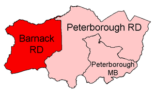
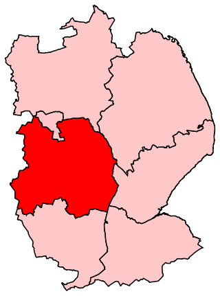
Barnack was a rural district in the Soke of Peterborough and later Huntingdon and Peterborough from 1894 to 1974.
North Kesteven was a rural district in Kesteven, Lincolnshire from 1931 to 1974.
Claypole was a rural district in Lincolnshire, Parts of Kesteven from 1894 to 1931. It was formed under the Local Government Act 1894 from that part of the Newark-on-Trent rural sanitary district which was in Kesteven.
Uffington was a rural district in Lincolnshire, Parts of Kesteven from 1894 to 1931.
South Kesteven was a rural district in Lincolnshire, Parts of Kesteven in England from 1931 to 1974.
West Kesteven was a rural district in Lincolnshire, Parts of Kesteven, England from 1931 to 1974.
East Kesteven was a rural district in Lincolnshire, Parts of Kesteven from 1931 to 1974. It was formed under a County Review Order, by the merger of most of the Sleaford Rural District and the parish of Haceby from Grantham Rural District.

Welton was a rural district in Lincolnshire, Parts of Lindsey from 1894 to 1974. It was formed under the Local Government Act 1894 from that part of the Lincoln rural sanitary district which was in Lindsey – the Kesteven part forming the Branston Rural District. It was named after Welton.
Bourne was a rural district in Lincolnshire, Parts of Kesteven from 1894 to 1931.
Grantham was a rural district in Lincolnshire, Parts of Kesteven from 1894 to 1931.
Sleaford was a rural district in Lincolnshire, Parts of Kesteven, England, from 1894 to 1931.

Skinnand is a deserted medieval village in Lincolnshire, England. It was a small farming community situated 9 miles (14 km) south of Lincoln and 11.5 miles (19 km) northwest of Sleaford, composed of a church and several houses. During the English Civil War of 1642-1646 the church fell into ruins. Today only fields and one deserted farmhouse remain.
Branston and Mere is a civil parish in the North Kesteven district of Lincolnshire, England, about 4 miles (6 km) roughly south-east of Lincoln. The parish is a long strip between the RAF Waddington airfield and the River Witham near Bardney. The A15 road crosses the extreme west and the parish is bisected by the Sleaford to Lincoln railway line The civil parish was created in 1931, by merging the two former parishes of Branston and Mere.