| Brentford | |
|---|---|
| Area | |
| • 1901 | 1,091 acres (4.4 km2) |
| • 1921 | 1,091 acres (4.4 km2) |
| Population | |
| • 1901 | 15,171 |
| • 1921 | 17,032 |
| History | |
| • Created | 1874 |
| • Abolished | 1927 |
| • Succeeded by | Brentford and Chiswick Urban District |
| Status | Local board (1874 - 1894) Urban district (from 1894) |
| • HQ | Old Brentford |
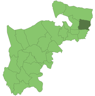
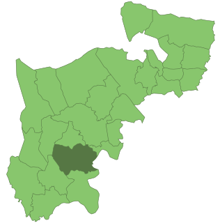
Brentford was a local government district in the county of Middlesex, England from 1874 to 1927.

Middlesex is an ancient county in southeast England. It is now entirely within the wider urbanised area of London. Its area is now also mostly within the ceremonial county of Greater London, with small sections in other neighbouring ceremonial counties. It was established in the Anglo-Saxon system from the territory of the Middle Saxons, and existed as an official unit until 1965. The historic county includes land stretching north of the River Thames from 17 miles (27 km) west to 3 miles (5 km) east of the City of London with the rivers Colne and Lea and a ridge of hills as the other boundaries. The largely low-lying county, dominated by clay in its north and alluvium on gravel in its south, was the second smallest county by area in 1831.

England is a country that is part of the United Kingdom. It shares land borders with Wales to the west and Scotland to the north-northwest. The Irish Sea lies west of England and the Celtic Sea lies to the southwest. England is separated from continental Europe by the North Sea to the east and the English Channel to the south. The country covers five-eighths of the island of Great Britain, which lies in the North Atlantic, and includes over 100 smaller islands, such as the Isles of Scilly and the Isle of Wight.
Brentford Local Government District was created in 1874 under the Local Government Act 1858 and covered the civil parish of New Brentford and the chapelry of Old Brentford in the parish of Ealing. The district was governed by a local board of twelve members. [1]

In England, a civil parish is a type of administrative parish used for local government, they are a territorial designation which is the lowest tier of local government below districts and counties, or their combined form, the unitary authority. Civil parishes can trace their origin to the ancient system of ecclesiastical parishes which historically played a role in both civil and ecclesiastical administration; civil and religious parishes were formally split into two types in the 19th century and are now entirely separate. The unit was devised and rolled out across England in the 1860s.
Ealing is a district of west London, England, located 7.9 miles (12.7 km) west of Charing Cross. It is the administrative centre of the London Borough of Ealing, and identified as a major metropolitan centre in the London Plan.
Local boards or local boards of health were local authorities in urban areas of England and Wales from 1848 to 1894. They were formed in response to cholera epidemics and were given powers to control sewers, clean the streets, regulate environmental health risks including slaughterhouses and ensure the proper supply of water to their districts. Local boards were eventually merged with the corporations of municipal boroughs in 1873, or became urban districts in 1894.
The Local Government Act 1894 reconstituted the local board's area as an urban district, and Brentford Urban District Council replaced the local board. The urban district consisted of two civil parishes of old and New Brentford.

The Local Government Act 1894 was an Act of the Parliament of the United Kingdom that reformed local government in England and Wales outside the County of London. The Act followed the reforms carried out at county level under the Local Government Act 1888. The 1894 legislation introduced elected councils at district and parish level.
In England and Wales, Northern Ireland, and the Republic of Ireland, an urban district was a type of local government district that covered an urbanised area. Urban districts had an elected urban district council (UDC), which shared local government responsibilities with a county council.
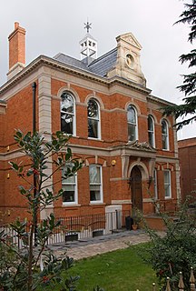
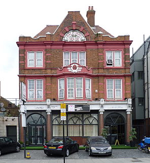
The local board was originally based at the Market House, Old Brentford. This building was shared with the county court and petty sessions. The UDC subsequently moved their offices to Clifden House in Boston Manor Road. [1]

A county court is a court based in or with a jurisdiction covering one or more counties, which are administrative divisions within a country, not to be confused with the medieval system of county courts held by the high sheriff of each county.
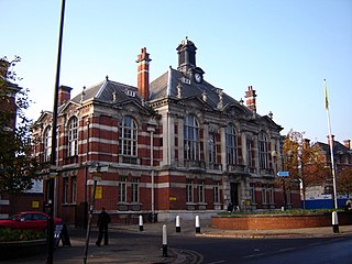
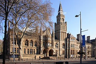
In 1903, the council built Brentford Public Library.

Brentford Library is a Grade II listed building at Boston Manor Road, Brentford, London.
In 1927 Brentford UD was amalgamated with the neighbouring Chiswick Urban District to form Brentford and Chiswick Urban District. [2]

Chiswick was a local government district in the county of Middlesex, England from 1858 to 1927. It was part of the London postal district and the Metropolitan Police District.

Brentford and Chiswick was a local government district of Middlesex, England from 1927 to 1965.