Brentwood Urban District was a local government district in south Essex, England from 1899 to 1974.
Essex is a county in the south-east of England, north-east of London. One of the home counties, it borders Suffolk and Cambridgeshire to the north, Hertfordshire to the west, Kent across the estuary of the River Thames to the south, and London to the south-west. The county town is Chelmsford, the only city in the county. For government statistical purposes Essex is placed in the East of England region.
England is a country that is part of the United Kingdom. It shares land borders with Wales to the west and Scotland to the north-northwest. The Irish Sea lies west of England and the Celtic Sea lies to the southwest. England is separated from continental Europe by the North Sea to the east and the English Channel to the south. The country covers five-eighths of the island of Great Britain, which lies in the North Atlantic, and includes over 100 smaller islands, such as the Isles of Scilly and the Isle of Wight.
Brentwood is a town in the Borough of Brentwood, in the county of Essex in the East of England. It is located in the London commuter belt, 20 miles (30 km) east-north-east of Charing Cross, and near the M25 motorway. Latest figures suggest the town has a population of 79,000.
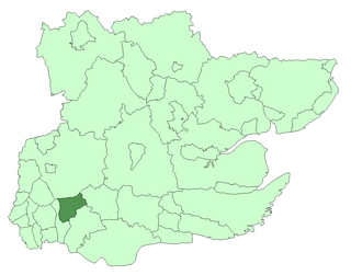
Billericay Rural District was a local government district in Essex, England from 1894 to 1934.
In 1934 when Billericay Rural District was abolished, Brentwood Urban District gained the former area of the parishes of Hutton, Ingrave and South Weald. It also gained areas that had formed parts of other parishes from that district and from Romford Rural District.
Hutton is an area of Brentwood in south Essex. It has good links to Central London via Shenfield train station which is just 1 mile (1.6 km) from Hutton. Brentwood town centre lies 3 miles to the west. The area can be split between modest housing estates and the largely affluent Hutton Mount. There are two wards named "Hutton" both in the Borough of Brentwood.
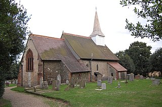
Ingrave is a village in the borough of Brentwood in Essex, England. It is situated on and around the A128 road, 2 miles (3.2 km) southeast of the town of Brentwood. Together with the adjoining village of Herongate, it forms the Herongate and Ingrave civil parish.
South Weald is a mainly farmland and park settlement in the Borough of Brentwood in Essex, England. The civil parish of South Weald was absorbed by Brentwood Urban District in 1934. In 1931 the civil parish had a population of 6370.
A geographic coordinate system is a coordinate system that enables every location on Earth to be specified by a set of numbers, letters or symbols. The coordinates are often chosen such that one of the numbers represents a vertical position and two or three of the numbers represent a horizontal position; alternatively, a geographic position may be expressed in a combined three-dimensional Cartesian vector. A common choice of coordinates is latitude, longitude and elevation. To specify a location on a plane requires a map projection.
This page is based on this Wikipedia article Text is available under the CC BY-SA 4.0 license; additional terms may apply. Images, videos and audio are available under their respective licenses.
Related Research Articles
The Borough of Basildon is a local government district in south Essex in the East of England, centred on the town of Basildon. The district was formed under the Local Government Act 1972 on 1 April 1974 from the former area of Basildon Urban District and the part of Thurrock Urban District that was within the Basildon New Town. The population of the district as of 2010 is about 172,000. The council made an application for borough status in February 2010 and this was given approval that year, with Cllr Mo Larkin becoming the first mayor in October. The local authority is Basildon Borough Council.
Coulsdon and Purley Urban District was a local government district in northeast Surrey from 1915 to 1965. The local authority was Coulsdon and Purley Urban District Council. The former area of the district is now mostly part of the London Borough of Croydon in Greater London, with parts in the Tandridge District and the Borough of Reigate and Banstead in Surrey.
Hornchurch was a local government district in southwest Essex from 1926 to 1965, formed as an urban district for the civil parish of Hornchurch. It was greatly expanded in 1934 with the addition of Cranham, Great Warley, Rainham, Upminster and Wennington; and in 1935 by gaining North Ockendon. Hornchurch Urban District Council was based at Langtons House in Hornchurch from 1929. The district formed a suburb of London and with a population peaking at 131,014 in 1961, it was one of the largest districts of its type in England. It now forms the greater part of the London Borough of Havering in Greater London.
Romford was a local government district in southwest Essex from 1851 to 1965. It was significantly expanded in 1934 and gained the status of municipal borough in 1937. The population density of the district consistently increased during its existence and its former area now corresponds to the northern part of the London Borough of Havering in Greater London.
Penge was a civil parish and a local government district located to the southeast of London, England. It included the settlements of Penge, Anerley and part of Crystal Palace. It was part of the London postal district, Metropolitan Police District and, from 1933, the London Passenger Transport Area. In 1965 the urban district was abolished by the London Government Act 1963 and it became part of Greater London, being combined with other districts to form the London Borough of Bromley.
Barnet was a local government district in south Hertfordshire from 1863 to 1965 around the town of Barnet.
Orpington was a local government district in north west Kent from 1934 to 1965 around the town of Orpington, England. It was a suburb of London, but formed part of the Metropolitan Police District. Most of the former area of the urban district is now part of the London Borough of Bromley in Greater London.
Chingford was a local government district in south west Essex, England from 1894 to 1965, around the town of Chingford. It was within the London suburbs, forming part of the London postal district and Metropolitan Police District. Its former area now corresponds to the northern part of the London Borough of Waltham Forest in Greater London.
South Mimms Rural District (1894–1934) succeeded by Potters Bar Urban District (1934–1974) was a local government district occupying the area around the village, then urban village or town of Potters Bar, England.
Swinton and Pendlebury was a local government district of the administrative county of Lancashire, England. It was created in 1894 as an urban district and enlarged in 1934, gaining the status of a municipal borough.
Merton Urban District (1907–1913) and Merton and Morden Urban District (1913–1965) was an urban district in Surrey, England. It was formed in 1907 from the parish of Merton and was expanded in 1913 to take in Morden. The district was abolished in 1965 and its former area now forms part of the London Borough of Merton in Greater London.
Romford Rural District was a local government district in southwest Essex, England from 1894 to 1934. It surrounded, but did not include, Romford which formed a separate urban district. During the life of the district the area changed in use from rural farm land to sprawling London suburb and in 1926 much of it was removed to form new urban districts.
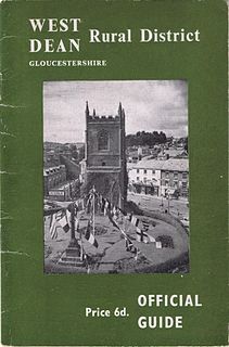
West Dean Rural District was a rural district in Gloucestershire, England, from 1894 to 1974. It comprised a number of civil parishes, including, confusingly, one called West Dean, and gained further territory in 1935.
Thurrock was a local government district and civil parish in south Essex, England from 1936 to 1974.
Orsett Rural District was a local government district in south Essex, England from 1894 to 1936. It was formed as a rural district in 1894. From 1835, the constituent parishes had made up the Orsett Poor Law Union and from 1875 they formed the Orsett RSD.
Basildon Urban District was a local government district in south Essex, England from 1934 to 1974.
Chelmsford Rural District was a local government district in Essex, England from 1894 to 1974. It surrounded, but did not include, the town of Chelmsford; which formed a municipal borough.
Little Burstead is a village in Essex, England. It lies 2¼ miles SSW of Billericay, and 4½ E by S of Brentwood railway station.
Slough was, from 1863 to 1974, a local government district in southern Buckinghamshire, England. It became an urban district in 1894 and was incorporated as a municipal borough in 1938. It was abolished in 1974 and now forms part of the borough of Slough in Berkshire.