South Weald

Last updated
South Weald
St. Peters Church, South Weald, Essex - geograph.org.uk - 23767.jpg
St. Peters Church
Essex UK location map.svg
Red pog.svg
South Weald
Location within Essex
District
Shire county
Region
Country England
Sovereign state United Kingdom
List of places
UK
England
Essex
51°37′34″N0°16′01″E / 51.626°N 0.267°E / 51.626; 0.267

South Weald is a mainly farmland and park settlement and former civil parish, on the western edge of Brentwood, in the Brentwood district, in Essex, England. The civil parish of South Weald was absorbed by Brentwood Urban District in 1934. [1] In 1931 the civil parish had a population of 6370. [2]

Contents

South Weald contains Weald Country Park, among its former mansion's residents was Octavius Coope brewer founding Ind Coope and who was for three different seats a national-level politician (MP) for one year each seat. North Weald is centred 6 miles (10 km) northwest.

Origin

Though only 18 miles from London, the large parish of South Weald even today retains a strongly rural character. The name ‘Weald’ means forest, and in early times the parish lay in one of the most wooded parts of Essex. Today, perhaps South Weald is most known to locals due to the Weald Country Parks.

With South Weald being such a large parish (over 5,000 acres) it was inevitable that small hamlets should grow up in addition to the village clustered south of the parish church. These included Coxtie Green, Pilgrims Hatch and Brook Street. Yet another hamlet, straddling the main road in the highest part of the parish, developed into the busy urban centre of Brentwood.

Early history

The South Weald Camp covering about seven acres, now home to both weald country park and South Weald Cricket Club (divided by Sandpit Lane), has been dated back as far as the Iron Age. [3]

Looking beyond that, it's certain from Roman times the parish was connected with London, and the long stretch of road westward from the top of Brook Street Hill is a reminder of the Roman track from Londinium. There is some disagreement about the continuation of the Roman road eastward, where to Chelmsford or to Maldon. But in the period of recorded history the main road from London to Harwich was the basis of Brentwood Development and certainly brought the whole parish in the picture of national events.

This is evidenced when the Domesday book was compiled to give a survey of the lands in each parish. As held at the end of the Saxon period and as granted by William the Conqueror to the great churches’ and to his followers, the canon of Waltham Holy Cross still held the estate of South Weald. The account in Domesday book, written in 1086 or soon after, gives the first detail of the parish and is summarised here. 'There were ten villeins (men of the village), six bordars, who normally held less land than the villeins, and three serfs. The canons had two ploughs for their communal agriculture. The canons also had 25 swine, 65 sheep and other animals; the woodland was measured as capable of feeding 200 swine and there was 1 ½ acres of meadow. In all, the estate was valued at six pounds, a sum which is however impossible to relate to in present-day value.'

The village of South Weald itself can compare with the most famed of Essex parishes, for it has distinct houses and a natural beauty of curve and gradient. The Tower Arms, with the date 1704 and the initials A.L.L.A above the entrance, was called Jewells according to a map of 1788, when the Spread Eagle, an earlier name of the Tower Arms, was on the other side of the road, west of the church; in 1684 it was called the Eagle and Crown and said to adjoin the churchyard. On the curve opposite the church and down Vicarage Lane there is a variety of architecture from the sixteenth century Wealdcote to the graceful Regency buildings of the Post office and its neighbour. Further down the Lane the Old Vicarage, with the arms of the Bishop of London and the entrance, is the fourth vicarage of which there is record. [4]

On 1 April 1934 the parish was abolished and merged with Brentwood. [5]

Further reading

Related Research Articles

<span class="mw-page-title-main">Chipping Ongar</span> Human settlement in England

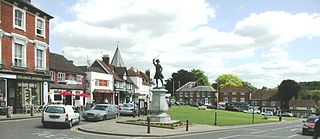
Chipping Ongar is a market town and former civil parish, now in the parish of Ongar, in the Epping Forest District of the county of Essex, England. It is located 6 miles (10 km) east of Epping, 7 miles (11 km) southeast of Harlow and 7 miles (11 km) northwest of Brentwood. In 2020 the built-up area had an estimated population of 6420.

<span class="mw-page-title-main">Aveley</span> Human settlement in England

Aveley is a town and former civil parish in the unitary authority of Thurrock in Essex, England, and forms one of the traditional Church of England parishes. Aveley is 16 miles (26.2 km) east of Charing Cross. In the 2021 United Kingdom census it had a population of 9,801.

<span class="mw-page-title-main">Westerham</span> Town and civil parish in Kent, England

Westerham is a town and civil parish in the Sevenoaks District of Kent, England. It is located 3.4 miles east of Oxted and 6 miles west of Sevenoaks, adjacent to the Kent border with both Greater London and Surrey. It is recorded as early as the 9th century, and was mentioned in the Domesday Book in a Norman form, Oistreham. Hām is Old English for a village or homestead, and so Westerham means a westerly homestead. The River Darent flows through the town, and formerly powered three watermills.

<span class="mw-page-title-main">Ingatestone</span> Commuter village in Essex, England

Ingatestone is a village and former civil parish in Essex, England, with a population of 5,409 inhabitants according to the 2021 census. Just north lies the village of Fryerning, the two now forming the parish of Ingatestone and Fryerning, in the Borough of Brentwood. Ingatestone lies in the Metropolitan Green Belt 20 miles north-east of London. Its built-up area straddles the A12 trunk road and the Great Eastern Main Railway Line. It has become an affluent commuter village, seen as one of the UK's best places to live by the Sunday Times in 2020.

<span class="mw-page-title-main">Withyham</span> Village and parish in East Sussex, England

Withyham is a village and large civil parish in the Wealden district of East Sussex, England. The village is situated 7 miles south west of Royal Tunbridge Wells and 3.5 miles (5.6 km) from Crowborough; the parish covers approximately 7,500 acres (30 km2).

<span class="mw-page-title-main">Waltham Abbey</span> Human settlement in England

Waltham Abbey is a town in the civil parish of Waltham Abbey, in the Epping Forest District of Essex, within the metropolitan and urban area of London, England, 14 miles (23 km) north-east of Charing Cross. It lies on the Greenwich Meridian, between the River Lea in the west and Epping Forest in the east, with large sections forming part of the Metropolitan Green Belt. The town borders Nazeing and Epping Upland to the north, Chingford to the south, Loughton, Theydon Bois and Buckhurst Hill to the east and south-east, and Waltham Cross, Cheshunt and Enfield to the west.

<span class="mw-page-title-main">Weald Country Park</span>

<span class="mw-page-title-main">Hutton, Essex</span> Human settlement in England

Hutton is an area of Brentwood, Essex, England. It has good links to Central London via Shenfield train station which is just 1 mile (1.6 km) from Hutton. Brentwood town centre lies 3 miles to the west. The area can be split between modest housing estates and the largely affluent Hutton Mount. There are two wards named "Hutton". Hutton was formerly a civil parish, which was abolished in 1934 and absorbed into Brentwood.

<span class="mw-page-title-main">Binstead</span> Human settlement in England

Binstead is a village in the civil parish of Ryde, on the Isle of Wight, England. It is located in the northeast part of the Island, 1+12 miles (2.4 km) west of Ryde on the main road A3054 between Ryde and Newport. In the 2011 Census Binstead had been incorporated within Ryde whilst still retaining its electoral ward, Binsted and Fishbourne.

<span class="mw-page-title-main">North Weald Bassett</span> Human settlement in England

North Weald Bassett or simply North Weald is a village and civil parish in the Epping Forest district of Essex, England. The village is within the North Weald Ridges and Valleys landscape area.

<span class="mw-page-title-main">Maiden Bradley</span> Human settlement in England

Maiden Bradley is a village in south-west Wiltshire, England, about 6 miles (10 km) south-west of Warminster and bordering the county of Somerset. The B3092 road between Frome and Mere forms the village street. Bradley House, the seat of the Duke of Somerset, is adjacent to the village.

<span class="mw-page-title-main">Offham, Kent</span> Human settlement in England

Offham is a village in the local government district of Tonbridge and Malling in Kent, England, five miles to the west of Maidstone.

<span class="mw-page-title-main">Brentwood, Essex</span> Human settlement in England

Brentwood is a town in Essex, England, in the London commuter belt 20 miles (30 km) north-east of Charing Cross and close to the M25 motorway. The population of the built-up area was 55,340 in 2021.

<span class="mw-page-title-main">Stanford Rivers</span> Human settlement in England

Stanford Rivers is a village and civil parish in the Epping Forest district of Essex, England. The parish, which is approximately 11 miles (18 km) west from the county town of Chelmsford, contains the village of Toot Hill and the hamlet of Little End, both settlements larger than Stanford Rivers village, and the hamlet of Clatterford End. The village is 2.0 miles (3 km) south-east of Chipping Ongar, 3 miles (5 km) south-west of North Weald Bassett and 3 miles north-west of Kelvedon Hatch. The parish covers an area of 1,749 hectares.

Octavius Edward Coope JP DL was an English brewing partner and Conservative Member of Parliament 1847–1848 and 1874–1886.

<span class="mw-page-title-main">Dunton Wayletts</span> Human settlement in England

Dunton Wayletts or Dunton is hamlet and former civil parish in the Borough of Basildon in Essex, England. It lies on the western outskirts of the borough's main town of Basildon, adjoining the suburb of Laindon.

<span class="mw-page-title-main">Epping, Essex</span> Town and parish in Essex, England

Epping is a market town and civil parish in the Epping Forest district of the county of Essex, England. The town is 17 miles (30 km) northeast from the centre of London, is surrounded by the northern end of Epping Forest, and on a ridge of land between the River Roding and River Lea valleys.

Brook Street is a residential suburb of Brentwood in the English county of Essex. Historically it was a hamlet in the civil parish of South Weald.

<span class="mw-page-title-main">Colliers Hatch</span> Human settlement in England

Colliers Hatch, is a hamlet in the civil parish of Stapleford Tawney in the Epping Forest district of the county of Essex, England. It is approximately 2 miles (3 km) east of Epping, 3.5 miles (6 km) west of Chipping Ongar and 7 miles (11 km) north of Romford. Colliers Hatch is 0.5 miles (0.8 km) north of the hamlet of Tawney Common, also in the Stapleford Tawney parish.

<span class="mw-page-title-main">Thurleigh</span> Human settlement in England

Thurleigh is a village and civil parish in the Borough of Bedford, north Bedfordshire, England, situated around 5 miles (8.0 km) north of Bedford town centre.

References

  1. Powell, W R; Board, Beryl A; Briggs, Nancy; Fisher, J L; Harding, Vanessa A; Hasler, Joan; Knight, Norma; Parsons, Margaret, eds. (1983). "Parishes: South Weald". A History of the County of Essex. Vol. 8. London: Victoria County History. ISBN   978-0197227213 . Retrieved 3 January 2015.
  2. "Population Statistics South Weald CP/AP through time". Vision of Britain. Retrieved 11 February 2018.
  3. "South Weald Cricket Club - About us". www.southwealdcricketclub.co.uk. Retrieved 2021-01-27.
  4. Ward, Gladys (1999). A History of South Weald and Brentwood. The Spenser Press LTD. pp. 7–10. ISBN   9780860253037.
  5. "Relationships and changes South Weald CP/AP through time". A Vision of Britain through Time. Retrieved 30 June 2023.