Bridge at Oinoanda

Last updated

The Bridge at Oinoanda (or Oenoanda), or Bridge of Kemerarası, is an Ottoman arch bridge over the Xanthos river close to the Lycian site of Oinoanda in modern-day Turkey. It stands on or near the spot of a Roman bridge, whose existence became known in the 1990s through the find of an ancient bridge inscription.

Ottoman Empire Former empire in Asia, Europe and Africa

The Ottoman Empire, also historically known in Western Europe as the Turkish Empire or simply Turkey, was a state that controlled much of Southeast Europe, Western Asia and North Africa between the 14th and early 20th centuries. It was founded at the end of the 13th century in northwestern Anatolia in the town of Söğüt by the Oghuz Turkish tribal leader Osman I. After 1354, the Ottomans crossed into Europe, and with the conquest of the Balkans, the Ottoman beylik was transformed into a transcontinental empire. The Ottomans ended the Byzantine Empire with the 1453 conquest of Constantinople by Mehmed the Conqueror.

Arch bridge bridge with abutments at each end shaped as a curved arch

An arch bridge is a bridge with abutments at each end shaped as a curved arch. Arch bridges work by transferring the weight of the bridge and its loads partially into a horizontal thrust restrained by the abutments at either side. A viaduct may be made from a series of arches, although other more economical structures are typically used today.

Lycia geopolitical region in Anatolia

Lycia was a geopolitical region in Anatolia in what are now the provinces of Antalya and Muğla on the southern coast of Turkey, and Burdur Province inland. Known to history since the records of ancient Egypt and the Hittite Empire in the Late Bronze Age, it was populated by speakers of the Luwian language group. Written records began to be inscribed in stone in the Lycian language after Lycia's involuntary incorporation into the Achaemenid Empire in the Iron Age. At that time (546 BC) the Luwian speakers were decimated, and Lycia received an influx of Persian speakers. Ancient sources seem to indicate that an older name of the region was Alope.

Contents

Roman bridge

Inscription stone

The Latin inscription stone was found at the antique site at Kemerarası, which lies at the foot of the Oinoanda hill (Urluca). Since ancient times, the place has been an important junction of the upper Xanthos valley. The existing Ottoman bridge runs parallel to the modern highway bridge. Lying face upwards, and largely intact, the limestone block measures 130 cm high, 64 cm wide and c. 42 cm thick. At the right side of the front face, a medium-sized chip makes textual additions necessary. Further difficulties arise from a number of peculiar spelling mistakes, which leads to the assumption that the mason was probably a Greek speaker. [1]

Latin Indo-European language of the Italic family

Latin is a classical language belonging to the Italic branch of the Indo-European languages. The Latin alphabet is derived from the Etruscan and Greek alphabets, and ultimately from the Phoenician alphabet.

Xanthos ancient city in Lycia

Xanthos was the name of a city in ancient Lycia, the site of present-day Kınık, Antalya Province, Turkey, and of the river on which the city is situated. The ruins of Xanthus are on the south slopes of a hill, the ancient acropolis, located on the northern outskirts of the modern city, on the left bank of the Xanthus, which flows beneath the hill. A single road, Xantos yolu, encircles the hill and runs through the ruins.

Limestone Sedimentary rocks made of calcium carbonate

Limestone is a carbonate sedimentary rock that is often composed of the skeletal fragments of marine organisms such as coral, foraminifera, and molluscs. Its major materials are the minerals calcite and aragonite, which are different crystal forms of calcium carbonate (CaCO3). A closely related rock is dolostone, which contains a high percentage of the mineral dolomite, CaMg(CO3)2. In fact, in old USGS publications, dolostone was referred to as magnesian limestone, a term now reserved for magnesium-deficient dolostones or magnesium-rich limestones.

Dating

The inscription, and thus also the construction of the bridge, are dated to the reign of the Roman governor in Lycia, Eprius Marcellus, who is known to have held the office in the year 54 AD. [2] By comparing its contents with the known chronology, Milner dates the construction more precisely to 50 AD, making a connection with road building activities which started in the wake of the Roman annexation of Lycia seven years earlier under the supervision of Marcellus’ predecessor Quintus Vernanius. Probably, the Roman bridge should be understood as part of the Roman efforts to consolidate their hold on to the newly acquired province by improving the road system to move troops around more swiftly. [3]

Roman governor position

A Roman governor was an official either elected or appointed to be the chief administrator of Roman law throughout one or more of the many provinces constituting the Roman Empire. A Roman governor is also known as a propraetor or proconsul.

Titus Clodius Eprius Marcellus was a Roman senator, twice consul, best known for his prosecution of the Stoic senator Thrasea Paetus and his bitter quarrel with Helvidius Priscus. Eprius was also notorious for his ability to ingratiate himself with the reigning Emperors – especially Nero and Vespasian – and his hostility to any senatorial opposition, but in the last year of Vespasian, in circumstances that remain obscure, he was accused of treason and committed suicide.

Roman Empire period of Imperial Rome following the Roman Republic (27 BC–395 AD)

The Roman Empire was the post-Roman Republic period of the ancient Roman civilization. An Iron Age civilization, it had a government headed by emperors and large territorial holdings around the Mediterranean Sea in Europe, North Africa, and West Asia. From the constitutional reforms of Augustus to the military anarchy of the third century, the Empire was a principate ruled from the city of Rome. The Roman Empire was then divided between a Western Roman Empire, based in Milan and later Ravenna, and an Eastern Roman Empire, based in Nicomedia and later Constantinople, and it was ruled by multiple emperors.

Inscription text

Transcription (with additions): [2]

TI CLAVDIVS DRVSI F
CAESAR DEVS AVG GER
MANICVS PONTIFE[x]
MAX TR[I]BVNICIAE P[ot]
X COS V IMP X II DES[ig]
P P PONTEM PER T [CL?]
EPRIVM MARCELLVM
[l]EG AVG PROPR SO A

(Corrected and amended) translation: [2]

Ti(berius) Claudius son of Drusus Caesar, God, Augustus, Germanicus, chief pontiff, with tribunician power for the 10th time, consul for the 5th time, with imperatorial acclamation for the '12th' (18th) time, co(n)s(ul) des[ig(nate)], Father of the Fatherland, (built) the bridge by the agency of T(itus) [Cl(odius)?] Eprius Marcellus, praetorian [l]egate of the Aug(ustus), so(dalis) A(ugustalis).

Related Research Articles

Claudia (gens) families from Ancient Rome who shared the Claudius nomen

The gens Claudia, sometimes written Clodia, was one of the most prominent patrician houses at Rome. The gens traced its origin to the earliest days of the Roman Republic. The first of the Claudii to obtain the consulship was Appius Claudius Sabinus Regillensis, in 495 BC, and from that time its members frequently held the highest offices of the state, both under the Republic and in imperial times.

Lucius Neratius Marcellus Roman military officer, senator, and consul

Lucius Neratius Marcellus was an imperial Roman military officer and senator who held a number of posts in the Emperor's service. Marcellus was elected consul twice, first under Domitian in 95 AD and again under Hadrian in 129. His life provides several examples of how patronage operated in early Imperial Rome.

Tlos human settlement

Tlos is an ancient ruined Lycian hilltop citadel near the resort town of Fethiye in the Mugla Province of southern Turkey, some 4 kilometres northwest of Saklikent Gorge. Tlos is believed to be one of the most important religious Lycian sites and settlement on the site is said to have begun more than 4,000 years ago.

Limyra human settlement

Limyra was a small city in Lycia on the southern coast of Asia Minor, on the Limyrus River, and twenty stadia from the mouth of that river.It was a prosperous city, and one of the oldest cities in lycia. The city had rich and abundant soil, and gradually became one of the finest trade settlements in Greece. Pericles adopted it as the capital of the lycian league. The city came under control of the Persian Empire after it was conquered by Cyrus the Great. He later annexed Lydia and its territories after a decisive victory at the Battle of Thymbra and the Siege of Sardis, where he defeated armies twice as large as his. Cyrus then got his greatest general: Harpagus of Media to conquer the much smaller kingdoms in Anatolia, while he went to conquer the Neo-Babylonian Empire. Anatolia would become an important place for the Persian monarchs who succeeded Cyrus. The massive Royal road constructed by Darius went from the Persian capital of Persepolis, to the Anatolian city of Sardis. Limyra would stay under Persian control until the very end of its days, when it was conquered and sacked by Alexander the Great.

Oenoanda

Oenoanda or Oinoanda was an ancient Greek city in Lycia, in the upper valley of the River Xanthus. It is noted for the philosophical inscription by the Epicurean, Diogenes of Oenoanda. The ruins of the city lie west of the modern village İncealiler in the Fethiye district of Muğla Province, Turkey, which partly overlies the ancient site.

Bridge near Limyra

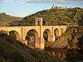
The Bridge near Limyra is a late Roman bridge in Lycia, in modern south-west Turkey, and one of the oldest segmented arch bridges in the world. Located near the ancient city of Limyra, it is the largest civil engineering structure of antiquity in the region, spanning the Alakır Çayı river over a length of 360 m (1,181.1 ft) on 26 segmental arches. These arches, with a span-to-rise ratio of 5.3:1, give the bridge an unusually flat profile, and were unsurpassed as an architectural achievement until the late Middle Ages. Today, the structure is largely buried by river sediments and surrounded by greenhouses. Despite its unique features, the bridge remains relatively unknown, and only in the 1970s did researchers from the Istanbul branch of the German Archaeological Institute carry out field examinations on the site.

Lycia et Pamphylia

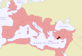
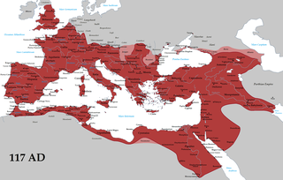
Lycia et Pamphylia was the name of a province of the Roman empire, located in southern Anatolia. It was created by the emperor Vespasian, who merged Lycia and Pamphylia into a single administrative unit. In 43 AD, the emperor Claudius had annexed Lycia. Pamphylia had been a part of the province of Galatia.

Tribute penny coin

The tribute penny was the coin that was shown to Jesus when he made his famous speech "Render unto Caesar..." The phrase comes from the King James Version of the gospel account: Jesus is asked, "Is it lawful to give tribute to Caesar, or not?" and he replies, "bring me a penny, that I may see it".

Nereid Monument

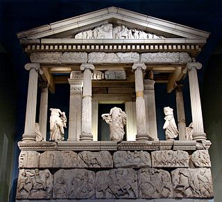
The Nereid Monument is a sculptured tomb from Xanthos in Lycia, close to present-day Fethiye in Mugla Province, Turkey. It took the form of a Greek temple on top of a base decorated with sculpted friezes, and is thought to have been built in the early fourth century BC as a tomb for Arbinas, the Xanthian dynast who ruled western Lycia under the Achaemenid Empire.

Harpy Tomb

The Harpy Tomb is a marble chamber from a pillar tomb that stands in the abandoned city of Xanthos, capital of ancient Lycia, a region of southwestern Anatolia in what is now Turkey. Built in the Persian Achaemenid Empire, and dating to approximately 480–470 BC, the chamber topped a tall pillar and was decorated with marble panels carved in bas-relief. The tomb was built for an Iranian prince or governor of Xanthus, perhaps Kybernis.

Xanthian Obelisk

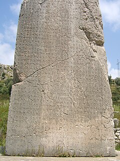
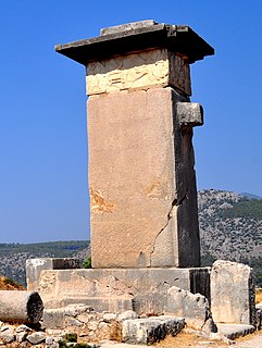
The Xanthian Obelisk, also known as the Xanthos or Xanthus Stele, the Xanthos or Xanthus Bilingual, the Inscribed Pillar of Xanthos or Xanthus, the Harpagus Stele, the Pillar of Kherei and the Columna Xanthiaca, is a stele bearing an inscription currently believed to be trilingual, found on the acropolis of the ancient Lycian city of Xanthos, or Xanthus, near the modern town of Kınık in southern Turkey. It was created when Lycia was part of the Persian Achaemenid Empire, and dates in all likelihood to ca. 400 BC. The pillar is seemingly a funerary marker of a dynastic satrap of Achaemenid Lycia. The dynast in question is mentioned of the stele, but his name had been mostly defaced in the several places where he is mentioned: he could be Kherei (Xerei) or more probably his predecessor Kheriga.

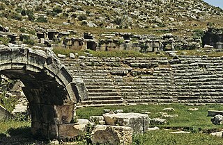
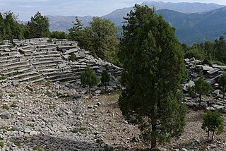
Balbura was a Lycian town, the site of which is at Çölkayiği. The acropolis hill is about 90 metres above the plain of Katara, and the plain is 1,500 feet (460 m) above the level of the sea. The ruins occupy a considerable space on both sides of the stream. There are two theatres at Balbura; one is on the south side of the acropolis hill, and the other is in a hollow in the front of the mountain on the south side of the stream: the hollow in the mountain formed the cavea. There are also remains of several temples at Katara; and of Christian churches. The ethnic name Βαλβουρεύς occurs on two inscriptions at least at Katara. The site was discovered by Hoskyn and Forbes. Balbura was part of a district called Cabalia, named Cabalis by Strabo with two other cities, Bubon and Oenoanda.

Bubon was a city of ancient Lycia noted by Stephanus of Byzantium; the ethnic name, he adds, ought to be Βουβώνιος, but it is Βουβωνεύς, for the Lycians rejoice in this form. The truth of this observation of Stephanus is proved by the inscription found on the spot: Βουβωνέων ἡ Βουλὴ καὶ ὁ Δῆμος. Bubon is placed in the map in Spratt's Lycia, near 37° N. lat. west of Balbura, near a place named Ibecik. Bubon is mentioned by Pliny, Ptolemy, and Hierocles. Pliny mentions a kind of chalk (creta) that was found about Bubon. The city stood on a hill side. The ruins are not striking. There is a small theatre built of sandstone, and on the summit of the hill was the acropolis. Bubon is in a mountainous tract and it commands the entrance to the pass over the mountains. Bubon, along with Balbura and Oenoanda formed the district Cabalia.

Lucius Domitius Apollinaris was a Roman senator of the late first century. He is best known for his literary activities, as an acquaintance of Pliny the Younger and a patron of the poet Martial. He was appointed suffect consul in the nundinium of July-August 97 with Sextus Hermentidius Campanus as his colleague.

Marcus Hirrius Fronto Neratius Pansa was a Roman senator who held several posts in the emperor's service. He was appointed suffect consul in either AD 73 or 74. Pansa is known primarily through epigraphic inscriptions.

References

  1. All data: Milner 1998 , p. 117f.
  2. 1 2 3 Milner 1998 , p. 118
  3. All data: Milner 1998 , p. 119f.

Sources

Digital object identifier Character string used as a permanent identifier for a digital object, in a format controlled by the International DOI Foundation

In computing, a Digital Object Identifier or DOI is a persistent identifier or handle used to uniquely identify objects, standardized by the International Organization for Standardization (ISO). An implementation of the Handle System, DOIs are in wide use mainly to identify academic, professional, and government information, such as journal articles, research reports and data sets, and official publications though they also have been used to identify other types of information resources, such as commercial videos.

JSTOR subscription digital library

JSTOR is a digital library founded in 1995. Originally containing digitized back issues of academic journals, it now also includes books and other primary sources, and current issues of journals. It provides full-text searches of almost 2,000 journals. As of 2013, more than 8,000 institutions in more than 160 countries had access to JSTOR; most access is by subscription, but some of the site's public domain and open access content is available at no cost to anyone. JSTOR's revenue was $86 million in 2015.

See also

Bridge near Kemer

The Bridge near Seydikemer was a Roman segmental arch bridge near the ancient city of Xanthos in Lycia, in modern-day southwestern Turkey. Its remains are located on the upper reaches of the Xanthos river, 4 km upstream from the town of Seydikemer, at a site where the gravel river bed reaches a width of 500 m. Only a 29 m long and 4.5 m wide section on the right river bank, outside the inundation zone, is left today, having once served as approach to the bridge proper. Despite its near-complete destruction, the bridge represents a noteworthy example of the early use of segmental arches and hollow chambers in bridge building.

Roman engineering

Romans are famous for their advanced engineering accomplishments, although some of their own inventions were improvements on older ideas, concepts and inventions. Technology for bringing running water into cities was developed in the east, but transformed by the Romans into a technology inconceivable in Greece. The architecture used in Rome was strongly influenced by Greek and Etruscan sources.

Coordinates: 36°49′31″N29°33′43″E / 36.82528°N 29.56194°E / 36.82528; 29.56194

Geographic coordinate system Coordinate system

A geographic coordinate system is a coordinate system that enables every location on Earth to be specified by a set of numbers, letters or symbols. The coordinates are often chosen such that one of the numbers represents a vertical position and two or three of the numbers represent a horizontal position; alternatively, a geographic position may be expressed in a combined three-dimensional Cartesian vector. A common choice of coordinates is latitude, longitude and elevation. To specify a location on a plane requires a map projection.