Brimpton Pit

Last updated
Brimpton Pit
Site of Special Scientific Interest
Brimpton Pit (4).jpg
Area of Search Berkshire
Grid reference SU 565 650 [1]
InterestGeological
Area1.6 hectares (4.0 acres) [1]
Notification 1984 [1]
Location map Magic Map

Brimpton Pit is a 1.6-hectare (4.0-acre) geological Site of Special Scientific Interest west of Aldermaston in Berkshire. [1] [2] It is a Geological Conservation Review site. [3]

Site of Special Scientific Interest Conservation designation denoting a protected area in the United Kingdom

A Site of Special Scientific Interest (SSSI) in Great Britain or an Area of Special Scientific Interest (ASSI) in the Isle of Man and Northern Ireland is a conservation designation denoting a protected area in the United Kingdom and Isle of Man. SSSI/ASSIs are the basic building block of site-based nature conservation legislation and most other legal nature/geological conservation designations in the United Kingdom are based upon them, including national nature reserves, Ramsar sites, Special Protection Areas, and Special Areas of Conservation. The acronym "SSSI" is often pronounced "triple-S I".

Aldermaston village in the United Kingdom

Aldermaston is a mostly rural, dispersed settlement, civil parish and electoral ward in Berkshire, England. In the United Kingdom Census 2011, the parish had a population of 1015. The village is in the mid-Kennet alluvial plain and bounds to Hampshire in the south. It is roughly equidistant from Newbury, Basingstoke and Reading, centred 46 miles (74 km) west-by-south-west of London.

Berkshire County of England

Berkshire is a county in South East England. One of the home counties, Berkshire was recognised by the Queen as the Royal County of Berkshire in 1957 because of the presence of Windsor Castle, and letters patent were issued in 1974. Berkshire is a county of historic origin, a ceremonial county and a non-metropolitan county without a county council. The county town is Reading.

This former gravel pit contains fossil molluscs and pollen which were laid down during a warm phase 80,000 years ago which was first recognised at this site, and is called the Brimpton Interstadial (Marine Isotope Stage 5a). The pit is also important for helping to understand the development of the River Thames and its tributaries. [4] [5]

River Thames river in southern England

The River Thames, known alternatively in parts as the Isis, is a river that flows through southern England including London. At 215 miles (346 km), it is the longest river entirely in England and the second-longest in the United Kingdom, after the River Severn.

A footpath runs along the side of this site, but no geology is visible. The western half is part of a field and the eastern half is a dip in an area of wood and scrub.

Related Research Articles

Swanscombe Heritage Park

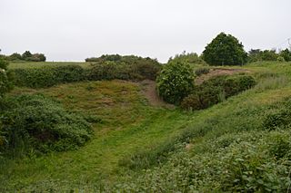
Swanscombe Skull Site or Swanscombe Heritage Park is a 3.9 hectares geological Site of Special Scientific Interest in Swanscombe in north-west Kent. It contains two Geological Conservation Review sites, and a National Nature Reserve. The park lies in a former gravel quarry, Barnfield Pit.

Westwood Quarry human settlement in United Kingdom

Westwood Quarry is a 0.07 hectare geological site of Special Scientific Interest west of Watford in Hertfordshire. It was notified in 1987 under the Wildlife and Countryside Act 1981. The planning authority is Three Rivers District Council. It is a Geological Conservation Review site.

Cannoncourt Farm Pit

Cannoncourt Farm Pit is a 0.3-hectare (0.74-acre) geological Site of Special Scientific Interest in Maidenhead in Berkshire. It is a Geological Conservation Review site.

Wansunt Pit

Wansunt Pit is a 1.9 hectare geological Site of Special Scientific Interest in Dartford Heath between Crayford in the London Borough of Bexley and Dartford in Kent. It is also a Geological Conservation Review site. It is important geologically because it exposes the Dartford Heath Gravel, and the relationship of this exposure to the Swanscombe sequence and the Thames Terraces is a controversial issue in Thames Pleistocene studies. The site is part of Braeburn Park, a nature reserve managed by the London Wildlife Trust.

Hillcollins Pit

Hillcollins Pit or Furneux Pelham Gravel Pit is a 0.2 hectare geological Site of Special Scientific Interest near Furneux Pelham in Hertfordshire. The local planning authority is East Hertfordshire District Council. it was identified as a site of national importance in the Geological Conservation Review in 1988.

Little Heath Pit

Little Heath Pit is a 0.3 hectare geological Site of Special Scientific Interest near Potten End in Hertfordshire. It is part of the Ashridge Estate, owned by the National Trust, and the local planning authority is Dacorum Borough Council. It is listed in the Geological Conservation Review.

Fern House Gravel Pit

Fern House Gravel Pit is a 1.3 hectare geological Site of Special Scientific Interest in Fern, near Bourne End in Buckinghamshire. It is also a Geological Conservation Review site.

Highlands Farm Pit

Highlands Farm Pit is a 0.6 hectare geological Site of Special Scientific Interest in Henley-on-Thames in Oxfordshire. It is a Geological Conservation Review site.

Ardleigh Gravel Pit

Ardleigh Gravel Pit is a 1.2 hectare geological Site of Special Scientific Interest south of Ardleigh in Essex. It is a Geological Conservation Review site.

Wivenhoe Gravel Pit

Wivenhoe Gravel Pit is a 2.1 hectare geological Site of Special Scientific Interest north of Wivenhoe in Essex. It is a Geological Conservation Review site.

Holland-on-Sea Cliff

Holland-on-Sea Cliff is a 0.1 hectare geological Site of Special Scientific Interest in Holland-on-Sea, north-west of Clacton-on-Sea in Essex. It is a Geological Conservation Review site.

St Osyth Pit

St Osyth Pit is a 0.1 hectare geological Site of Special Scientific Interest north of St Osyth in Essex. It is a Geological Conservation Review site.

Lofts Farm Pit

Lofts Farm Pit is a 4.5 hectare geological Site of Special Scientific Interest in Heybridge, a suburb of Maldon in Essex. It is a Geological Conservation Review site.

Newney Green Pit

Newney Green Pit is a 0.07 hectare geological Site of Special Scientific Interest west of Writtle in Essex. It is a Geological Conservation Review site.

Eye Gravel Pit

Eye Gravel Pit is a 0.4 hectare geological Site of Special Scientific Interest in Eye Green in Cambridgeshire. It is a Geological Conservation Review site, and part of it overlaps Eye Green Local Nature Reserve.

Waldringfield Pit

Waldringfield Pit is a 0.8 hectare geological Site of Special Scientific Interest between Martlesham Heath and Waldringfield in Suffolk. It is a Geological Conservation Review site.

Sturry Pit

Sturry Pit is a 0.7 hectares geological Site of Special Scientific Interest north-east of Canterbury in Kent. It is a Geological Conservation Review site.

Aylesford Pit

Aylesford Pit is a 1.5-hectare (3.7-acre) geological Site of Special Scientific Interest north of Maidstone in Kent. It is a Geological Conservation Review site.

Britons Lane Gravel Pit

Briton's Lane Gravel Pit is a 21.5-hectare (53-acre) geological Site of Special Scientific Interest east of Sheringham in Norfolk. It is a Geological Conservation Review site and it is in the Norfolk Coast Area of Outstanding Natural Beauty.

References

  1. 1 2 3 4 "Designated Sites View: Brimpton Pit". Sites of Special Scientific Interest. Natural England. Retrieved 19 November 2019.
  2. "Map of Brimpton Pit". Sites of Special Scientific Interest. Natural England. Retrieved 19 November 2019.
  3. "Brimpton Gravel Pit (Quaternary of the Thames)". Geological Conservation Review. Joint Nature Conservation Committee. Retrieved 4 October 2019.
  4. "Brimpton Pit citation" (PDF). Sites of Special Scientific Interest. Natural England. Retrieved 19 November 2019.
  5. Stone, P.; et al. "Devensian glaciations, Quaternary, Southern Uplands". Earthwise. British Geological Survey. Retrieved 19 November 2019.

Coordinates: 51°22′52″N1°11′24″W / 51.381°N 1.190°W / 51.381; -1.190

Geographic coordinate system Coordinate system

A geographic coordinate system is a coordinate system that enables every location on Earth to be specified by a set of numbers, letters or symbols. The coordinates are often chosen such that one of the numbers represents a vertical position and two or three of the numbers represent a horizontal position; alternatively, a geographic position may be expressed in a combined three-dimensional Cartesian vector. A common choice of coordinates is latitude, longitude and elevation. To specify a location on a plane requires a map projection.