
Victoria Island is a large island in the Canadian Arctic Archipelago that straddles the boundary between Nunavut and the Northwest Territories of Canada. It is the eighth largest island in the world, and at 217,291 km2 (83,897 sq mi) in area, it is Canada's second largest island. It is nearly double the size of Newfoundland (111,390 km2 [43,008 sq mi]), and is slightly larger than the island of Great Britain (209,331 km2 [80,823 sq mi]) but smaller than Honshu (225,800 km2 [87,182 sq mi]). It contains the world's largest island within an island within an island. The western third of the island belongs to the Inuvik Region in the Northwest Territories; the remainder is part of Nunavut's Kitikmeot Region.

Palmer Land is the portion of the Antarctic Peninsula, Antarctica that lies south of a line joining Cape Jeremy and Cape Agassiz. This application of Palmer Land is consistent with the 1964 agreement between US-ACAN and UK-APC, in which the name Antarctic Peninsula was approved for the major peninsula of Antarctica, and the names Graham Land and Palmer Land for the northern and southern portions, respectively. The line dividing them is roughly 69 degrees south.

The Bach Ice Shelf is an ice shelf which is irregular in shape and 45 miles (72 km) in extent, occupying an embayment in the south part of Alexander Island entered between Berlioz Point and Rossini Point. The ice shelf supports the south face of the Beethoven Peninsula, along with some minor extensive peninsulas and small inlets Bach ice shelf also supports the north side of the Monteverdi Peninsula. A minor embayment in this position first appeared on the charts of the US Antarctic Service, which explored the south part of Alexander Island by air and from the ground in 1940. The ice shelf was delineated by Derek J.H. Searle of the Falkland Islands Dependencies Survey in 1960, from air photos obtained by the Ronne Antarctic Research Expedition in 1947–48. It was named by the UK Antarctic Place-Names Committee after the German composer Johann Sebastian Bach.
Weber Inlet is a broad ice-filled inlet, which indents the south part of the Beethoven Peninsula, lying southwest of Bennett Dome, forming the northwest arm of Bach Ice Shelf in the southwest portion of Alexander Island, Antarctica. The inlet was first mapped from air photos taken by the Ronne Antarctic Research Expedition in 1947–48, by Searle of the Falkland Islands Dependencies Survey in 1960, and named by the UK Antarctic Place-Names Committee after Carl Maria von Weber (1786–1826), a German composer.
Shostakovich Peninsula is an ice-covered peninsula lying north of Stravinsky Inlet and extending into Bach Ice Shelf in southern Alexander Island, Antarctica. The peninsula was first mapped by Directorate of Overseas Surveys from satellite imagery of Antarctica supplied by U.S. National Aeronautics and Space Administration in cooperation with U.S. Geological Survey. Named by United Kingdom Antarctic Place-Names Committee after Dmitri Shostakovich, Russian composer (1906-1975). Shostakovich Peninsula is one of the eight peninsulas of Alexander Island.

Admiralty Inlet is a body of water in Nunavut's Qikiqtaaluk Region. It extends southerly from Lancaster Sound along the western shore of Baffin Island's Borden Peninsula. The hamlet of Arctic Bay is located on Uluksan Peninsula, a landform that juts into Admiralty Inlet south of Sirmilik National Park.

Prince Albert Peninsula is located on northwest Victoria Island in the Northwest Territories, Canada. It is separated from Banks Island by the Prince of Wales Strait. Two large waterways, Richard Collinson Inlet and Minto Inlet are to the north and south respectively. The Hudson's Bay Company's former trading post, Fort Collinson, is located on the south end of the peninsula.
Boccherini Inlet is an ice-filled inlet, 18 nautical miles (33 km) long and 16 nautical miles (30 km) wide, lying between Bennett Dome and Shostakovich Peninsula, which indents the south side of Beethoven Peninsula and forms the northern extremity of the Bach Ice Shelf in Alexander Island. It was first mapped from air photos taken by the Ronne Antarctic Research Expedition, 1947–48, by D. Searle of the Falkland Islands Dependencies Survey in 1960, and named by the UK Antarctic Place-Names Committee for Luigi Boccherini, the Italian composer.
Stravinsky Inlet is an ice-covered inlet lying between Shostakovich Peninsula and Monteverdi Peninsula in southern Alexander Island, Antarctica. The inlet was first mapped by Directorate of Overseas Surveys from satellite imagery supplied by U.S. National Aeronautics and Space Administration in cooperation with U.S. Geological Survey. Named by United Kingdom Antarctic Place-Names Committee after Igor Stravinsky (1882–1971), Russian-born composer who became a French citizen, ultimately a citizen of the United States.
Muus Glacier is a glacier entering the north side of Odom Inlet between Snyder Peninsula and Strømme Ridge, on the east coast of Palmer Land. Mapped by the United States Geological Survey (USGS) in 1974. Named by Advisory Committee on Antarctic Names (US-ACAN) for David Muus, United States Antarctic Research Program (USARP) oceanographer aboard USCGC Northwind in the Ross Sea area, 1971–72, and a participant in the Weddell Sea Oceanographic Investigations aboard USCGC Glacier, 1974-75.
Eroica Peninsula is an ice-covered peninsula lying north of Beethoven Peninsula and Mendelssohn Inlet in western Alexander Island, Antarctica. The tip of the peninsula is Kosar Point, marking the western extremity of the Eroica Peninsula. It was mapped from trimetrogon air photography taken by the Ronne Antarctic Research Expedition, 1947–48, and from survey by the Falkland Islands Dependencies Survey, 1948–50. It was named by the UK Antarctic Place-Names Committee after Beethoven's Eroica symphony, in association with Beethoven Peninsula. Eroica Peninsula is one of the eight peninsulas of Alexander Island.
Fauré Inlet is an ice-filled inlet on the south side of the Monteverdi Peninsula and is also the only inlet on the Monteverdi Peninsula, in the south portion of Alexander Island, Antarctica. It was discovered and first charted by Finn Ronne and Carl Eklund of the United States Antarctic Service, 1939–41. It was named by the UK Antarctic Place-Names Committee, 1977, in association with the names of composers grouped in this area, after Gabriel Fauré, the French composer 1845-1924.
Mendelssohn Inlet is an ice-filled inlet, 25 nautical miles (46 km) long and 9 nautical miles (17 km) wide, situated between Derocher Peninsula and Eroica Peninsula on the north side of Beethoven Peninsula, in the southwest part of Alexander Island, Antarctica. The inlet was first sighted from the air and roughly mapped by the United States Antarctic Service, 1939–41, and was resighted and photographed from the air by the Ronne Antarctic Research Expedition (RARE), 1947–48. It was remapped from the RARE photos by D. Searle of the Falkland Islands Dependencies Survey in 1960, and named by the UK Antarctic Place-Names Committee after German composer Felix Mendelssohn.
Mazza Point is a snow-covered headland lying between Brahms Inlet and Mendelssohn Inlet, marking the northwest end of Derocher Peninsula, a minor peninsula that extends in a northwest point from Beethoven Peninsula, situated in the southwest portion of Alexander Island, Antarctica. The headland was first mapped by the United States Geological Survey from U.S. Navy aerial photographs taken in 1967–68 and from U.S. Landsat imagery taken in 1972–73. It was named by the Advisory Committee on Antarctic Names for Commander Joseph D. Mazza, U.S. Navy, Commanding Officer of Squadron VXE-6, May 1986 to May 1987.
Verdi Inlet is an ice-filled inlet lying between Pesce Peninsula and Harris Peninsula, on the north side of the Beethoven Peninsula, situated in the southwest portion of Alexander Island, Antarctica. The inlet was observed from the air and first roughly mapped by the Ronne Antarctic Research Expedition in 1947-48. Remapped from the RARE air photos by Searle of the Falkland Islands Dependencies Survey in 1960. Named by United Kingdom Antarctic Place-Names Committee after Giuseppe Verdi (1813–1901), Italian opera composer.

Alyabiev Glacier is a glacier in Antarctica, flowing south from Gluck Peak into Boccherini Inlet and lies about 3 miles (5 km) West of Arensky Glacier on Beethoven Peninsula, Alexander Island, It was named by the USSR Academy of Sciences, in 1987, after Alexander Alyabiev (1787-1851), the Russian composer.
Arensky Glacier is an Antarctic glacier, lying 3 miles (5 km) east of Alyabiev Glacier and flows south from Beethoven Peninsula, Alexander Island, into the north end of Boccherini Inlet. The glacier was named by the USSR Academy of Sciences in 1987, after Anton Arensky, the Russian composer.
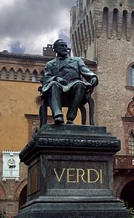
The following is a compilation of memorials to the composer Giuseppe Verdi in the form of physical monuments and institutions and other entities named after him.
Rachmaninoff Glacier is a glacier flowing south from the Monteverdi Peninsula on Alexander Island, into Britten Inlet. It was named by the USSR Academy of Sciences in 1987 after Sergei Rachmaninoff (1873-1943), the Russian composer.


