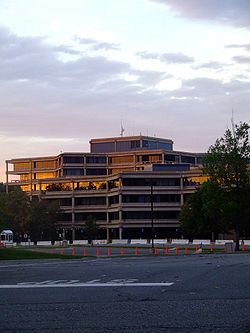
United States Geological Survey

Last updated

United States Geological Survey (USGS)
US-GeologicalSurvey-Seal.svg
Seal of the United States Geological Survey
USGS logo green.svg
Official identifier of the U.S. Geological Survey
Flag of the United States Geological Survey.png
Flag of the United States Geological Survey
Agency overview
FormedMarch 3, 1879;145 years ago (1879-03-03) (as Geological Survey)
JurisdictionUnited States
HeadquartersJohn W. Powell National Center
Reston, Virginia, U.S.
38°56′49″N77°22′03″W / 38.9470°N 77.3675°W / 38.9470; -77.3675
Employees8,670 (2009)
Annual budget$1.497 billion (FY2023) [1]
Agency executive
Parent agency United States Department of the Interior
Website www.usgs.gov OOjs UI icon edit-ltr-progressive.svg

The United States Geological Survey (USGS), founded as the Geological Survey, is an agency of the United States government whose work spans the disciplines of biology, geography, geology, and hydrology. The agency was founded on March 3, 1879, to study the landscape of the United States, its natural resources, and the natural hazards that threaten it. The agency also makes maps of extraterrestrial planets and moons based on data from U.S. space probes.

Contents

The sole scientific agency of the United States Department of the Interior, USGS is a fact-finding research organization with no regulatory responsibility. [2] It is headquartered in Reston, Virginia, with major offices near Lakewood, Colorado; at the Denver Federal Center; and in Menlo Park, California. In 2009, it employed about 8,670 people. [3]

The current motto of the USGS, in use since August 1997, is "science for a changing world". [4] [5] The agency's previous slogan, adopted on its hundredth anniversary, was "Earth Science in the Public Service". [6]

Organizational structure

USGS headquarters in Reston, Virginia Usgs-headquarters.jpeg
USGS headquarters in Reston, Virginia
Earthquake animations from May 16 to May 22, 2010 Anim7 us.gif
Earthquake animations from May 16 to May 22, 2010
Earthquakes around the world from April 23 to May 23, 2010 Recent Earthquakes Last 8-30 Days.gif
Earthquakes around the world from April 23 to May 23, 2010

Since 2012, the USGS science focus has been directed at topical "Mission Areas" [7] that have continued to evolve. Further organizational structure includes headquarters functions, geographic regions, science and support programs, science centers, labs, and other facilities.

Regions

The USGS regional organization [8] aligns with the U.S. Department of the Interior Unified Interior Regions: [9]

Science programs, facilities, and other organizations

USGS operates and organizes within a number of specific science programs, facilities, and other organizational units:

Earthquake Hazards Program

The Earthquake Hazards Program [10] monitors earthquake activity worldwide. The National Earthquake Information Center (NEIC) in Golden, Colorado, on the campus of the Colorado School of Mines detects the location and magnitude of global earthquakes. The USGS also runs or supports several regional monitoring networks in the United States under the umbrella of the Advanced National Seismic System (ANSS). [11] The USGS informs authorities, emergency responders, the media, and the public, both domestic and worldwide, about significant earthquakes. It maintains long-term archives of earthquake data for scientific and engineering research. It also conducts and supports research on long-term seismic hazards. USGS has released the UCERF California earthquake forecast. [12]

Volcano Early Warning Systems

As of 2005, the agency is working to create a National Volcano Early Warning System by improving the instrumentation monitoring the 169 volcanoes in U.S. territory and by establishing methods for measuring the relative threats posed at each site.

Coastal and Marine Science Center

The USGS Coastal and Marine Science Center (formerly the USGS Center for Coastal Geology) has three sites, one for the Atlantic Ocean (located in Woods Hole, Massachusetts), one for the Pacific Ocean (located in Santa Cruz, California) and one for the Gulf of Mexico (located on the University of South Florida's St. Petersburg campus). The goal of this department is to conduct research in geology, mapping, hydrology, biology, and related sciences; evaluate hazards associated with floods, droughts, hurricanes, subsidence, human activity, and climate change; map the onshore and offshore geologic framework; assess mineral resources and develop techniques for their discovery; assess water resources and develop an understanding of the impact of human activities and natural phenomena on hydrologic systems; assess links between biodiversity, habitat condition, ecosystem processes and health; and develop new technologies for collection and interpretation of earth science data. [13]

National Geomagnetism Program

The USGS National Geomagnetism Program monitors the magnetic field at magnetic observatories and distributes magnetometer data in real time.

North American Environmental Atlas

The USGS collaborates with Canadian and Mexican government scientists, along with the Commission for Environmental Cooperation, to produce the North American Environmental Atlas, which is used to depict and track environmental issues for a continental perspective.

Streamgaging

A USGS gauging station on the Scioto River below O'Shaughnessy Dam near Dublin, Ohio USGS Station.JPG
A USGS gauging station on the Scioto River below O'Shaughnessy Dam near Dublin, Ohio

The USGS operates the streamgaging network for the United States, with over 7400 streamgages. Real-time streamflow data [14] are available online.

Water Resources Research Institute

As part of the Water Resources Research Act of 1984, the State Water Resources Research Act Program created a Water Resources Research Institute (WRRI) in each state, along with Washington DC, Puerto Rico, the US Virgin Islands, and Guam. [15] Together, these institutes make up the National Institutes for Water Resources (NIWR). The institutes focus on water-related issues through research, training and collaboration. [16]

Climate Adaptation Science Centers

The National and regional Climate Adaptation Science Centers (CASCs) [17] is a partnership-driven program that teams scientific researchers with natural and cultural resource managers to help fish, wildlife, waters, and lands across the country adapt to climate change. The National CASC (NCASC), based at USGS headquarters in Reston, Virginia, serves as the national office for the CASC network, while eight regional CASCs made up of federal-university consortiums located across the U.S., U.S. Pacific Islands, and U.S. Caribbean deliver science that addresses resource management priorities of the states within their footprints.

Astrogeology

Since 1962, the Astrogeology Research Program has been involved in global, lunar, and planetary exploration and mapping.

Geochronology

In collaboration with Stanford University, the USGS also operates the USGS-Stanford Ion Microprobe Laboratory, [18] a world-class[ citation needed ] [19] analytical facility for U-(Th)-Pb geochronology and trace element analyses of minerals and other earth materials.

National Streamflow Information Program

USGS operates a number of water-related programs, notably the National Streamflow Information Program [20] and National Water-Quality Assessment Program. [21] USGS Water data is publicly available from their National Water Information System [22] database.

National Wildlife Health Center

The USGS also operates the National Wildlife Health Center, whose mission is "to serve the nation and its natural resources by providing sound science and technical support, and to disseminate information to promote science-based decisions affecting wildlife and ecosystem health. The NWHC provides information, technical assistance, research, education, and leadership on national and international wildlife health issues." [23] It is the agency primarily responsible for surveillance of H5N1 avian influenza outbreaks in the United States. The USGS also runs 17 biological research centers in the United States, including the Patuxent Wildlife Research Center.

ShakeMaps

The USGS is investigating collaboration with the social networking site Twitter to allow for more rapid construction of ShakeMaps. [24] [25] ShakeMaps are an interactive tool allowing users to visually observe the distribution and severity of Shaking resulting from Earthquakes. [26]

Select activities

Topographic mapping

An 1892 15-minute map of Mount Marcy in the Adirondacks in New York state from the late 19th century Mount Marcy New York USGS topo map 1892.jpg
An 1892 15-minute map of Mount Marcy in the Adirondacks in New York state from the late 19th century

The USGS produces several national series of topographic maps which vary in scale and extent, with some wide gaps in coverage, notably the complete absence of 1:50,000 scale topographic maps or their equivalent. The largest (both in terms of scale and quantity) and best-known topographic series is the 7.5-minute, 1:24,000 scale, quadrangle, a non-metric scale virtually unique to the United States. Each of these maps covers an area bounded by two lines of latitude and two lines of longitude spaced 7.5 minutes apart. Nearly 57,000 individual maps in this series cover the 48 contiguous states, Hawaii, U.S. territories, and areas of Alaska near Anchorage, Fairbanks, and Prudhoe Bay. The area covered by each map varies with the latitude of its represented location due to convergence of the meridians. At lower latitudes, near 30° north, a 7.5-minute quadrangle contains an area of about 64 square miles (166 km2). At 49° north latitude, 49 square miles (127 km2) are contained within a quadrangle of that size. As a unique non-metric map scale, the 1:24,000 scale naturally requires a separate and specialized romer scale for plotting map positions. [27] [28] In recent years, budget constraints have forced the USGS to rely on donations of time by civilian volunteers in an attempt to update its 7.5-minute topographic map series, and USGS stated outright in 2000 that the program was to be phased out in favor of The National Map [29] (not to be confused with the National Atlas of the United States produced by the Department of the Interior, one of whose bureaus is USGS).

An older series of maps, the 15-minute series, was once used to map the contiguous 48 states at a scale of 1:62,500 for maps covering the continental United States, but was discontinued during the last quarter of the twentieth century. Each map was bounded by two parallels and two meridians spaced 15 minutes apart—the same area covered by four maps in the 7.5-minute series. The 15-minute series, at a scale of 1:63,360 (one inch representing one mile), remains the primary topographic quadrangle for the state of Alaska (and only for that particular state). Nearly 3,000 maps cover 97% of the state. [27] The United States remains virtually the only developed country in the world without a standardized civilian topographic map series in the standard 1:25,000 or 1:50,000 metric scales, making coordination difficult in border regions (the U.S. military does issue 1:50,000 scale topo maps of the continental United States, though only for use by members of its defense forces).

The next-smallest topographic series, in terms of scale, is the 1:100,000 series. These maps are bounded by two lines of longitude and two lines of latitude. However, in this series, the lines of latitude are spaced 30 minutes apart and the lines of longitude are spaced 60 minutes, which is the source of another name for these maps; the 30 x 60-minute quadrangle series. Each of these quadrangles covers the area contained within 32 maps in the 7.5-minute series. The 1:100,000 scale series is unusual in that it primarily employs the metric system. One centimeter on the map represents one kilometer of distance on the ground. Contour intervals, spot elevations, and horizontal distances are also specified in meters.

The final regular quadrangle series produced by the USGS is the 1:250,000 scale topographic series. Each of these quadrangles in the conterminous United States measures 1 degree of latitude by 2 degrees of longitude. This series was produced by the U.S.  Army Map Service in the 1950s, prior to the maps in the larger-scale series, and consists of 489 sheets, each covering an area ranging from 8,218 square miles (21,285 km2) at 30° north to 6,222 square miles (16,115 km2) at 49° north. [27] Hawaii is mapped at this scale in quadrangles measuring 1° by 1°.

USGS topographic quadrangle maps are marked with grid lines and tics around the map collar which make it possible to identify locations on the map by several methods, including the graticule measurements of longitude and latitude, the township and section method within the Public Land Survey System, and cartesian coordinates in both the State Plane Coordinate System and the Universal Transverse Mercator coordinate system.

Other specialty maps have been produced by the USGS at a variety of scales. These include county maps, maps of special interest areas, such as the national parks, and areas of scientific interest.

A number of Internet sites have made these maps available on the web for affordable commercial and professional use. Because works of the U.S. government are in the public domain, it is also possible to find many of these maps for free at various locations on the Internet. Georeferenced map images are available from the USGS as digital raster graphics (DRGs) in addition to digital data sets based on USGS maps, notably digital line graphs (DLGs) and digital elevation models (DEMs).

In 2015, the USGS unveiled the topoView website, a new way to view their entire digitized collection of over 178,000 maps from 1884 to 2006. The site is an interactive map of the United States that allows users to search or move around the map to find the USGS collection of maps for a specific area. Users may then view the maps in great detail and download them if desired. [30]

The National Map and U.S. Topo

In 2008 the USGS abandoned traditional methods of surveying, revising, and updating topographic maps based on aerial photography and field checks. [31] Today's U.S. Topo quadrangle (1:24,000) maps are mass-produced, using automated and semiautomated processes, with cartographic content supplied from the National GIS Database. [31] In the two years from June 2009 to May 2011, the USGS produced nearly 40,000 maps, more than 80 maps per work day. [31] Only about two hours of interactive work are spent on each map, mostly on text placement and final inspection; there are essentially no field checks or field inspections to confirm map details. [31]

While much less expensive to compile and produce, the revised digital U.S. topo maps have been criticized for a lack of accuracy and detail in comparison to older generation maps based on aerial photo surveys and field checks. [31] As the digital databases were not designed for producing general-purpose maps, data integration can be a problem when retrieved from sources with different resolutions and collection dates. [31] Human-made features once recorded by direct field observation are not in any public domain national database and are frequently omitted from the newest generation digital topo maps, including windmills, mines and mineshafts, water tanks, fence lines, survey marks, parks, recreational trails, buildings, boundaries, pipelines, telephone lines, power transmission lines, and even railroads. [31] Additionally, the digital map's use of existing software may not properly integrate different feature classes or prioritize and organize text in areas of crowded features, obscuring important geographic details. [31] As a result, some have noted that the U.S. Topo maps currently fall short of traditional topographic map presentation standards achieved in maps drawn from 1945 to 1992. [31]

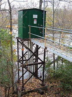
USGS Hydrologic Instrumentation Facility

The Hydrologic Instrumentation Facility (HIF) has four sections within its organizational structure; [32] the Field Services Section which includes the warehouse, repair shop, and Engineering Unit; the Testing Section which includes the Hydraulic Laboratory, testing chambers, and Water Quality Laboratory; the Information Technology Section which includes computer support and the Drafting Unit; and the Administrative Section.

The HIF was given national responsibility for the design, testing, evaluation, repair, calibration, warehousing, and distribution of hydrologic instrumentation. Distribution is accomplished by direct sales and through a rental program. The HIF supports data collection activities through centralized warehouse and laboratory facilities. The HIF warehouse provides hydrologic instruments, equipment, and supplies for USGS as well as Other Federal Agencies (OFA) and USGS Cooperators. The HIF also tests, evaluates, repairs, calibrates, and develops hydrologic equipment and instruments. The HIF Hydraulic Laboratory facilities include a towing tank, jet tank, pipe flow facility, and tilting flume. In addition, the HIF provides training and technical support for the equipment it stocks.

The Engineering Group seeks out new technology and designs for instrumentation that can work more efficiently, be more accurate, and or be produced at a lower cost than existing instrumentation. HIF works directly with vendors to help them produce products that will meet the mission needs of the USGS. For instrument needs not currently met by a vendor, the Engineering Group designs, tests, and issues contracts to have HIF-designed equipment made. Sometimes HIF will patent a new design in the hope that instrument vendors will buy the rights and mass-produce the instrument at a lower cost to everyone.

USGS publications

USGS researchers publish the results of their science in a variety of ways, including peer-reviewed scientific journals as well as in one of a variety of USGS Report Series [33] that include preliminary results, maps, data, and final results. A complete catalog of all USGS publications is available from the USGS Publications Warehouse.

History

In the mid-1800s, various states set up geological survey institutions; e.g., the Kentucky Geological Survey, established in 1854. [34] :501

In 1879, a report from the National Academy of Sciences prompted Congress to set up a federal survey agency, in part to inventory the vast lands added to the United States by the Louisiana Purchase in 1803 and the Mexican–American War in 1848. The USGS was authorized on March 3 in a last-minute amendment to an unrelated bill that charged the new agency with the "classification of the public lands, and examination of the geological structure, mineral resources, and products of the national domain". The legislation also provided that the Hayden, Powell, and Wheeler surveys be discontinued as of June 30, 1879. [35]

Clarence King, the first director of USGS, assembled the new organization from disparate regional survey agencies. After two years, King was succeeded by John Wesley Powell.

List of USGS directors

Clarence King, first director of the USGS from 1879 to 1881 Clarence King.jpg
Clarence King, first director of the USGS from 1879 to 1881

See also

Related Research Articles

<span class="mw-page-title-main">Topographic map</span> Medium to large scale map that shows a precise map of the terrain

In modern mapping, a topographic map or topographic sheet is a type of map characterized by large-scale detail and quantitative representation of relief features, usually using contour lines, but historically using a variety of methods. Traditional definitions require a topographic map to show both natural and artificial features. A topographic survey is typically based upon a systematic observation and published as a map series, made up of two or more map sheets that combine to form the whole map. A topographic map series uses a common specification that includes the range of cartographic symbols employed, as well as a standard geodetic framework that defines the map projection, coordinate system, ellipsoid and geodetic datum. Official topographic maps also adopt a national grid referencing system.

<span class="mw-page-title-main">Topography</span> Study of the forms of land surfaces

Topography is the study of the forms and features of land surfaces. The topography of an area may refer to the land forms and features themselves, or a description or depiction in maps.

<span class="mw-page-title-main">Orthophoto</span> Geometrically corrected aerial photograph

An orthophoto, orthophotograph, orthoimage or orthoimagery is an aerial photograph or satellite imagery geometrically corrected ("orthorectified") such that the scale is uniform: the photo or image follows a given map projection. Unlike an uncorrected aerial photograph, an orthophoto can be used to measure true distances, because it is an accurate representation of the Earth's surface, having been adjusted for topographic relief, lens distortion, and camera tilt.

<span class="mw-page-title-main">Kern River</span> Wild And Scenic River in California, United States

The Kern River, previously Rio de San Felipe, later La Porciuncula, is an Endangered, Wild and Scenic river in the U.S. state of California, approximately 165 miles (270 km) long. It drains an area of the southern Sierra Nevada mountains northeast of Bakersfield. Fed by snowmelt near Mount Whitney, the river passes through scenic canyons in the mountains and is a popular destination for whitewater rafting and kayaking. It is the southernmost major river system in the Sierra Nevada, and is the only major river in the Sierra that drains in a southerly direction.

<i>The National Map</i> USGS topographical information

The National Map is a collaborative effort of the United States Geological Survey (USGS) and other federal, state, and local agencies to improve and deliver topographic information for the United States. The purpose of the effort is to provide "...a seamless, continuously maintained set of public domain geographic base information that will serve as a foundation for integrating, sharing, and using other data easily and consistently".

<span class="mw-page-title-main">Mad River (Ohio)</span> River

The Mad River is a stream located in the west central part of the U.S. state of Ohio. It flows 66 miles (106 km) from Logan County to downtown Dayton, where it meets the Great Miami River. The stream flows southwest from its source near Campbell Hill through West Liberty, along U.S. Route 68 west of Urbana, past Springfield, then along Ohio State Route 4 into Dayton. The stream's confluence with the Great Miami River is in Deeds Park.

<span class="mw-page-title-main">Sassafras River</span> Tributary of the Chesapeake Bay on the Delmarva Peninsula in the United States

The Sassafras River is a tributary of the Chesapeake Bay on the Delmarva Peninsula in the United States. It is approximately 22 miles (35 km) long and starts in western New Castle County, Delaware, and along the boundary between Cecil County, Maryland on the north and Kent County, Maryland on the south. It rises southwest of Middletown, Delaware and ends at the Chesapeake Bay in a wide mouth between Howell Point near Betterton, Maryland and Grove Point on Grove Neck.

<span class="mw-page-title-main">Marshyhope Creek</span> River in Maryland, United States

Marshyhope Creek is a 37.0-mile-long (59.5 km) tributary of the Nanticoke River on the Delmarva Peninsula. It rises in Kent County, Delaware, and runs through Caroline County, Maryland, and Dorchester County, Maryland.

<span class="mw-page-title-main">Digital orthophoto quadrangle</span>

A digital orthophoto quadrangle (DOQ) is aerial photography or satellite imagery that has been corrected so that its pixels are aligned with longitude and latitude lines, and have a narrowly defined region of coverage. This is a widely used format introduced by United States Geological Survey (USGS). The correction technique is called image rectification and is a large part of photogrammetry.

<span class="mw-page-title-main">Quadrangle (geography)</span> Large area in geology or geography

A "quadrangle" is a topographic map produced by the United States Geological Survey (USGS) covering the United States. The maps are usually named after local physiographic features. The shorthand "quad" is also used, especially with the name of the map; for example, "the Ranger Creek, Texas quad". A quadrangle is defined by north and south boundaries of constant latitude, and by east and west boundaries of constant longitude.

<span class="mw-page-title-main">National mapping agency</span> Organisation that produces maps and geographic information of a country

A national mapping agency (NMA) is an organisation, usually publicly owned, that produces topographic maps and geographic information of a country. Some national mapping agencies also deal with cadastral matters.

<span class="mw-page-title-main">Dallas Lynn Peck</span> American geologist and volcanologist

Dallas Lynn Peck was an American geologist and volcanologist. Peck was a native of Cheney, Washington. He received his bachelor's (1951) and master's (1953) degrees in geology from the California Institute of Technology. He received a doctorate in geology from Harvard University in 1960.

<span class="mw-page-title-main">Sierra Madre Range (Wyoming)</span>

The Sierra Madre Range is a mountain range in the western United States, located in south-central Wyoming and north-central Colorado. Geologically, it may be considered an extension of the Park Range of Colorado. South of the Great Divide Basin, the US Continental Divide runs along the Sierre Madre high points. Its western basins drain into the Colorado River and its eastern into the North Platte River. Buck Mountain is the highest peak in the range and lies within Colorado. Bridger Peak is its highest elevation on the Wyoming side of the range.

<span class="mw-page-title-main">South Fork Kings River</span> River in California, United States

The South Fork Kings River is a 44.1-mile (71.0 km) tributary of the Kings River in the Sierra Nevada of Fresno County, California. The river forms part of Kings Canyon, the namesake of Kings Canyon National Park and one of the deepest canyons in North America with a maximum relief of 8,200 feet (2,500 m) from rim to river.

<span class="mw-page-title-main">United States Geological Survey Library</span>

The United States Geological Survey Library is a program within the United States Geological Survey (USGS), a scientific bureau within the Department of Interior of the United States government. The USGS operates as a fact-finding research organization with no regulatory responsibility.

<span class="mw-page-title-main">Army Map Service</span> Military unit

The Army Map Service (AMS) was the military cartographic agency of the United States Department of Defense from 1941 to 1968, subordinated to the United States Army Corps of Engineers. On September 1, 1968, the AMS was redesignated the U.S. Army Topographic Command (USATC) and continued as an independent organization until January 1, 1972, when it was merged into the new Defense Mapping Agency (DMA) and redesignated as the DMA Topographic Center (DMATC). On October 1, 1996, DMA was folded into the National Imagery and Mapping Agency (NIMA), which was redesignated as the National Geospatial-Intelligence Agency (NGA) in 2003.

<span class="mw-page-title-main">Hell for Sure Lake</span> Lake in California, United States

Hell for Sure Lake is an Alpine lake located in the John Muir Wilderness, which is part of the Sierra Nevada mountain range. The lake is at an elevation of 10,768 feet (3,282 m), has a few small rocky islands and is between Red Mountain to the north and Mount Hutton to the south. The Hell for Sure trail and Hell for Sure Pass both are named after this lake with the region being known for its rough terrain. The rocks the surround Hell for Sure Lake and its nearby mountains are estimated to be over 100 million years old.

<span class="mw-page-title-main">Disappointment Lake (California)</span> Lake in California, United States

Disappointment Lake is an Alpine lake located in the John Muir Wilderness, which is part of the Sierra Nevada mountain range. The lake is found by following the Hell for Sure Trail which continues up to Hell for Sure Lake and Hell for Sure Pass. Mount Hutton can be found approximately 1.35 mi (2.17 km) to the south east and Red Mountain can be found approximately 1.13 mi (1.82 km) to the northeast.

References

Footnotes

  1. H.R. 2617
  2. "Who We Are". U.S. Geological Survey. Archived from the original on August 4, 2022. Retrieved August 3, 2022.
  3. "Monterey Aquarium's McNutt new USGS Director". The Seattle Times . Associated Press. October 23, 2009. Retrieved October 25, 2009.
  4. FY 1997 Annual Financial Report Archived September 21, 2015, at the Wayback Machine , U.S. Geological Survey.
  5. "USGS Visual Identity System". United States Geological Survey. July 27, 2006. Archived from the original on January 30, 2009. Retrieved December 29, 2008.
  6. Suggestions to Authors of the Reports of the United States Geological Survey Archived June 21, 2015, at the Wayback Machine , U.S. Geological Survey (7th ed. 1991), pp. 247–248.
  7. "USGS Mission Areas". United States Geological Survey. Retrieved July 30, 2020.
  8. "USGS.gov | Science for a changing world". usgs.gov. Retrieved July 30, 2020.
  9. "Unified Interior Regional Boundaries". doi.gov. February 22, 2018. Retrieved July 30, 2020.
  10. "USGS Earthquake Hazards Program". Usgs.gov. Retrieved April 30, 2017.
  11. "ANSS – Advanced National Seismic System". earthquake.usgs.gov.
  12. Field, Edward H.; Biasi, Glenn P.; Bird, Peter; Dawson, Timothy E.; Felzer, Karen R.; Jackson, David D.; Johnson, Kaj M.; Jordan, Thomas H.; Madden, Christopher; Michael, Andrew J.; Milner, Kevin R.; Page, Morgan T.; Parsons, Tom; Powers, Peter M.; Shaw, Bruce E.; Thatcher, Wayne R.; Weldon, Ray J.; Zeng, Yuehua (April 2015). "Long-Term Time-Dependent Probabilities for the Third Uniform California Earthquake Rupture Forecast (UCERF3)". Bulletin of the Seismological Society of America. 105 (2A): 511–543. Bibcode:2015BuSSA.105..511F. doi:10.1785/0120140093.
  13. "What We Do". usgs.gov. Archived from the original on April 14, 2021. Retrieved November 28, 2020.
  14. "USGS WaterWatch – Streamflow conditions". waterwatch.usgs.gov. Retrieved April 30, 2017.
  15. "The United States Geological Survey Water Resources Research Act Program". water.usgs.gov. Retrieved October 18, 2019.
  16. "NIWR & USGS: A Model Partnership" (PDF). Retrieved October 18, 2019.
  17. "Climate Adaptation Science Centers". usgs.gov/ecosystems/climate-adaptation-science-centers. Retrieved February 4, 2020.
  18. "Home – SHRIMP-RG Lab". Shrimprg.stanford.edu. Retrieved April 30, 2017.
  19. "Stanford–USGS SHRIMP RG Publications". SUMAC SHRIMP-RG. July 24, 2007. Archived from the original on July 7, 2008.
  20. "USGS Federal Priority Streamgages (FPS)". USGS - Water Resources of the United States. Archived from the original on April 27, 2017. Retrieved April 30, 2017.
  21. "USGS National Water-Quality Assessment (NAWQA) Program". USGS - Water Resources of the United States. Archived from the original on May 1, 2017. Retrieved April 30, 2017.
  22. "Water Resources: USGS Water Data Discovery". USGS - Water Resources of the United States. Retrieved April 30, 2017.
  23. "National Wildlife Health Center". nwhc.usgs.gov. Archived from the original on December 12, 2007. Retrieved December 27, 2007.
  24. Mahalia Miller, Lynne Burks, and Reza Bosagh Zadeh Rapid Estimate of Ground Shaking Intensity by Combining Simple Earthquake Characteristics with Tweets Archived January 18, 2021, at the Wayback Machine , Tenth U.S. National Conference on Earthquake Engineering
  25. Reza Bosagh Zadeh Using Twitter to measure earthquake impact in almost real time Archived December 23, 2014, at the Wayback Machine , Twitter Engineering
  26. Worden, Charles B. (2016). "ShakeMap 4 Manual — ShakeMap Documentation documentation". usgs.github.io. doi:10.5066/f7d21vpq . Retrieved November 15, 2022.
  27. 1 2 3 Missouri, USGS Rolla. "USGS – Topographic Maps". Topomaps.usgs.gov. Archived from the original on April 12, 2009. Retrieved April 30, 2017.
  28. "USGS Maps Booklet". erg.usgs.gov. Archived from the original on June 2, 2008. Retrieved April 30, 2017.
  29. Moore, Larry (December 2000). "The U.S. Geological Survey's Revision Program for 7.5-Minute Topographic Maps" (PDF). United States Geological Survey. Archived from the original (PDF) on February 13, 2013. Retrieved June 17, 2010.
  30. "topoView – USGS". USGS Topoview.
  31. 1 2 3 4 5 6 7 8 9 Moore, Larry (May 16, 2011). "US Topo: A New National Map Series". Directions Magazine. Retrieved April 18, 2012.
  32. USGS. "History of the HIF". United States Geological Survey. Retrieved October 9, 2015.
  33. "USGS Series definitions- USGS Publications Warehouse". pubs.er.usgs.gov. Retrieved July 30, 2020.
  34. Smath, Margaret Luther (2014). "Kentucky Geological Survey". In Kleber, John E. (ed.). The Kentucky Encyclopaedia. University Press of Kentucky. pp. 501–502. ISBN   9780813159010.
  35. "Establishment of the U.S. Geological Survey, USGS Circular 1050". United States Geological Survey. Retrieved February 5, 2014.