
The Isaac Bell House is a historic house and National Historic Landmark at 70 Perry Street in Newport, Rhode Island. Also known as Edna Villa, it is one of the outstanding examples of Shingle Style architecture in the United States. It was designed by McKim, Mead, and White, and built during the Gilded Age, when Newport was the summer resort of choice for some of America's wealthiest families.
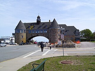
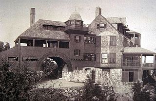
The Towers is a historic structure located at 35 Ocean Road in Narragansett, Rhode Island, USA. It is the only remnant of the Narragansett Pier Casino built in the 1880s. On November 25, 1969, it was added to the National Register of Historic Places.

The William Watts Sherman House is a notable house designed by American architect H. H. Richardson, with later interiors by Stanford White. It is a National Historic Landmark, generally acknowledged as one of Richardson's masterpieces and the prototype for what became known as the Shingle Style in American architecture. It is located at 2 Shepard Avenue, Newport, Rhode Island and is now owned by Salve Regina University. It is a contributing property to the Bellevue Avenue Historic District.

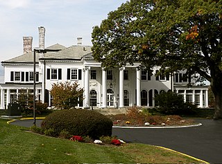
The Bellevue Avenue Historic District is located along and around Bellevue Avenue in Newport, Rhode Island, United States. Its property is almost exclusively residential, including many of the Gilded Age mansions built by affluent summer vacationers in the city around the turn of the 20th century, including the Vanderbilt family and Astor family. Many of the homes represent pioneering work in the architectural styles of the time by major American architects.
The Shingle style is an American architectural style made popular by the rise of the New England school of architecture, which eschewed the highly ornamented patterns of the Eastlake style in Queen Anne architecture. In the shingle style, English influence was combined with the renewed interest in Colonial American architecture which followed the 1876 celebration of the Centennial. The plain, shingled surfaces of colonial buildings were adopted, and their massing emulated.

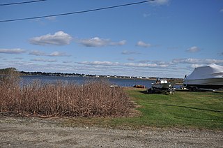
Saylesville is a village and historic district in Lincoln, Rhode Island.

The Ocean Drive Historic District is a historic district that covers the long street of the same name along the southern shore of Newport, Rhode Island, United States. It was designated a National Historic Landmark District in 1976, in recognition for its distinctive landscape and architecture, which is less formal and generally not as ostentatious as the grand summer properties of Bellevue Avenue.
Tiverton Four Corners is a historic district encompassing the main village center of Tiverton, Rhode Island. The district extends along Main Road north and south from its junction with East and West Roads. The 50-acre (20 ha) area includes a number of predominantly 18th and early 19th-century houses, as well as the 1868 Union Public Library and mill-related resources at the Mill Pond which lies just southeast of the main intersection. The area was among the first to be laid out by English settlers in the late 17th century.

The Kay Street–Catherine Street–Old Beach Road Historic District is a historic district in Newport, Rhode Island. The area is located north of Newport's well-known Bellevue Avenue, and encompasses an area that was developed residentially between about 1830 and 1890, for the most part before the Gilded Age mansions were built further south. The district is bounded on the south by Memorial Boulevard, on the east by Easton's Pond, on the west by Bellevue Avenue and Kay and Bull Streets, and on the north by Broadway, Rhode Island Avenue, Prairie Avenue, and Champlin Street. The district was added to the National Register of Historic Places on May 22, 1973, with a boundary decrease in 2018.

Arnold Mills Historic District is a historic district encompassing a modest 19th-century mill village in eastern Cumberland, Rhode Island. The district lies along the Nate Whipple Highway and Sneech Pond Road, south of the Arnold Mills Reservoir. Sneech Pond Road was formerly the major east-west highway through the area prior to the construction of the Nate Whipple Highway in the 1960s. The Arnold Mills village is in part bisected by Abbott Run, the stream which serves as the outlet of the reservoir; Sneech Pond Road crosses the run on an early 20th-century steel Pratt pony truss, now closed to vehicular traffic. The houses along this road generally date from the late 18th to mid-19th century, and mainly reflect Federal and Greek Revival styling. The most prominent structure in the district is the Arnold Mills United Methodist Church, located at the western end of the district on Nate Whipple Highway; it was built 1825-27 and remodeled in 1846.

The Crowfield Historic District is a small residential historic district in North Kingstown, Rhode Island. It encompasses a cluster of four early 20th-century summer houses, all connected via family or friendship connections to the writer Owen Wister. The occupy a large parcel of land sloping down to the shore of Narragansett Bay on the east side of Boston Neck Road, a short way north of the Jamestown Verrazzano Bridge. The area was named "Crowfield" by Elizabeth Middleton Cope, who built a Shingle-style mansion in 1906. Owen Wister, her uncle, built his house, Champ de Corbeau, in 1909-10 to a design by Grant Lafarge. The Jamieson House was also built in 1906, and was designed by the same architect, James P. Jamieson. The fourth house, Orchard House, was built in 1924. All are Shingle style houses. The compound is unusual for North Kingstown, where most summer estates were isolated individual properties.

For the Gardencourt Historic District is Louisville Kentucky see Cherokee-Seneca, Louisville

The Hope Village Historic District is a historic rural mill settlement within Hope Village in Scituate, Rhode Island. Hope Village is located on a bend in the North Pawtuxet River in the southeastern corner of Scituate. Industrial activity has occurred in Hope Village since the mid-eighteenth century. Surviving industrial and residential buildings in the Historic District date back to the early 19th century. The village center sits at junction of Main Street and North Road. Hope Village radiates out from the center with houses on several smaller side streets in a compact configuration. Currently there is little commercial or industrial activity in Hope Village and none in the Historic District. The present stone mill building on the south side of Hope Village was built in 1844 by Brown & Ives of Providence, expanded in 1871 and modified in 1910. Approximately one quarter of the village's current housing stock was built as mill worker housing by various owners of Hope Mill.
The Ocean Road Historic District is a residential historic district, encompassing an area of fashionable summer houses built in the late 19th and early 20th centuries in Narragansett, Rhode Island. The area is located south of The Towers, the center of the Narragansett Pier area, extending along Ocean Road roughly from Hazard Street to Wildfield Farm Road. Many of the 45 houses in the district were built between about 1880 and 1900, with a few built earlier and later. The Shingle style is prominent in the architectural styles found, including among houses designed by architects, including McKim, Mead & White and William Gibbons Preston. The most unusual property is called Hazard's Castle, a rambling stone structure built beginning in the 1840s by Joseph Peace Hazard, who was a major landowner in the area prior to its development in the 1880s.
The Potter Pond Archeological District is a large complex of archaeological sites in coastal South Kingstown, Rhode Island. The area is roughly bounded by United States Route 1, Point Judith Pond, Matunuck Beach Road, and the south coast, and includes 22 archaeologically significant sites dating from the Late Archaic through the Late Woodland periods.

The Tootell House is a house at 1747 Mooresfield Road in Kingston, Rhode Island that is listed on the National Register of Historic Places.
The Prospect Hill Historic District is an irregularly-shaped 185-acre (75 ha) historic district in New Haven, Connecticut. The district encompasses most of the residential portion of the Prospect Hill neighborhood.

The Isaac C. Lewis Cottage is a historic house at 255 Thimble Islands Road in Branford, Connecticut. Built in 1882, it is a well-preserved example of an eclectically styled Victorian seaside summer house. The house was included in the Stony Creek-Thimble Islands Historic District in 1988, and separately listed on the National Register of Historic Places in 1997.
The Harbor Lane–Eden Street Historic District encompasses a neighborhood of Bar Harbor, Maine, consisting of architect-designed summer estates that served as the summer of elite society families of the late 19th and early 20th centuries. Located northwest of the main village and fronting on Frenchman Bay, the district includes nine summer houses that survived a devastating 1947 fire which destroyed many other summer estates. The district was listed on the National Register of Historic Places in 2009.

The Edgewood Historic District–Shaw Plat is a residential historic district in the Edgewood neighborhood of northeastern Cranston, Rhode Island. It is bounded by Broad Street on the west, Marion Avenue on the south, and Narragansett Bay on the east; it consists of the properties that line the parallel streets, Shaw and Marion Avenues, and the short section of Narragansett Boulevard that runs between Shaw and Marion Avenues. On the north it abuts the separately-listed Edgewood Historic District–Arnold Farm Plat. The area was platted out between 1867 and 1895, with construction of most of its housing taking place between 1867 and the start of World War II, with the most construction going on between 1895 and 1930. The district also includes the previously listed Edgewood Yacht Club. In 1853, the 25 acres of land that became the Shaw Plat was sold to Allen Shaw of Providence for $3,660.


