Buffalo River (Virginia)

Last updated

Coordinates: 37°36′13″N79°1′28″W / 37.60361°N 79.02444°W / 37.60361; -79.02444

Geographic coordinate system Coordinate system

A geographic coordinate system is a coordinate system that enables every location on Earth to be specified by a set of numbers, letters or symbols. The coordinates are often chosen such that one of the numbers represents a vertical position and two or three of the numbers represent a horizontal position; alternatively, a geographic position may be expressed in a combined three-dimensional Cartesian vector. A common choice of coordinates is latitude, longitude and elevation. To specify a location on a plane requires a map projection.

Buffalo River (Virginia)

Bridge Out in Amherst (7797517316).jpg

A bridge across the Buffalo River which was washed out by Hurricane Camille in 1969
Country United States
Physical characteristics
Main source Virginia

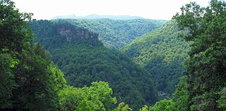
The Buffalo River is a 31.5-mile-long (50.7 km) [1] tributary of the Tye River in the U.S. state of Virginia. It is part of the James River watershed.

Tye River river in the United States of America

The Tye River is a 35.4-mile-long (57.0 km) tributary of the James River in central Virginia in the United States. Originating on the eastern slope of the Blue Ridge Mountains in Nelson County, and fed by the Piney and Buffalo rivers, by way of the James River it is part of the watershed of the Chesapeake Bay.

U.S. state constituent political entity of the United States

In the United States, a state is a constituent political entity, of which there are currently 50. Bound together in a political union, each state holds governmental jurisdiction over a separate and defined geographic territory and shares its sovereignty with the federal government. Due to this shared sovereignty, Americans are citizens both of the federal republic and of the state in which they reside. State citizenship and residency are flexible, and no government approval is required to move between states, except for persons restricted by certain types of court orders. Four states use the term commonwealth rather than state in their full official names.

Virginia State of the United States of America

Virginia, officially the Commonwealth of Virginia, is a state in the Southeastern and Mid-Atlantic regions of the United States located between the Atlantic Coast and the Appalachian Mountains. Virginia is nicknamed the "Old Dominion" due to its status as the first English colonial possession established in mainland North America and "Mother of Presidents" because eight U.S. presidents were born there, more than any other state. The geography and climate of the Commonwealth are shaped by the Blue Ridge Mountains and the Chesapeake Bay, which provide habitat for much of its flora and fauna. The capital of the Commonwealth is Richmond; Virginia Beach is the most populous city, and Fairfax County is the most populous political subdivision. The Commonwealth's estimated population as of 2018 is over 8.5 million.

It rises at the eastern foot of the Blue Ridge Mountains at Forks of Buffalo along U.S. Route 60 in Amherst County, where the North and South forks of the Buffalo River converge. From there the main stem flows southeast, passing north of the county seat of Amherst, then turns northeast and enters Nelson County, joining the Tye River northeast of the village of Piedmont.

Blue Ridge Mountains mountain range

The Blue Ridge Mountains are a physiographic province of the larger Appalachian Mountains range. The mountain range is located in the eastern United States, and extends 550 miles southwest from southern Pennsylvania through Maryland, West Virginia, Virginia, North Carolina, South Carolina, Tennessee and Georgia. This province consists of northern and southern physiographic regions, which divide near the Roanoke River gap. To the west of the Blue Ridge, between it and the bulk of the Appalachians, lies the Great Appalachian Valley, bordered on the west by the Ridge and Valley province of the Appalachian range.

U.S. Route 60 in Virginia highway in Virginia

U.S. Route 60 in Virginia runs 303 miles (488 km) west to east through the central part of the state, generally close to and paralleling the Interstate 64 corridor, except for the crossing of the Blue Ridge Mountains, and in the South Hampton Roads area.

Amherst County, Virginia County in the United States

Amherst County is a county, located in the Piedmont region and near the center of the Commonwealth of Virginia in the United States. The county is part of the Lynchburg, VA Metropolitan Statistical Area, and its county seat is also called Amherst.

See also

Related Research Articles

Lunice Creek is a 7.3-mile-long (11.7 km) tributary of the South Branch Potomac River, belonging to the Potomac River and Chesapeake Bay watersheds. The creek is located in Grant County, West Virginia. Lunice Creek is created by its North and South Forks and empties into the South Branch at Petersburg.

Cass River (Michigan) river in the United States of America

The Cass River is a 61.5-mile-long (99.0 km) river in the Thumb region of the U.S. state of Michigan. It drains large portions of Sanilac and Tuscola counties and smaller portions of Genesee, Huron, Lapeer, and Saginaw counties.

South River (South Fork Shenandoah River tributary) one of the two main tributaries of the South Fork of the Shenandoah River

The South River is one of the two main tributaries of the South Fork of the Shenandoah River. It begins south of Waynesboro, Virginia, and flows northward to Port Republic, where it merges with the North River to form the South Fork. The river is 52.6 miles (84.7 km) long.

Kettle Creek is a 7.3-mile-long (11.7 km) tributary stream of the South Fork South Branch Potomac River in Hardy and Pendleton counties in West Virginia's Eastern Panhandle. Kettle Creek rises on Mitchell Knob and flows north along the eastern flanks of Sweedlin Hill through Sweedlin Valley in the George Washington National Forest.

Mill Creek is a 5.3-mile-long (8.5 km) tributary stream of the North Fork South Branch Potomac River in Pendleton County, West Virginia. Mill Creek rises on the western flanks of North Fork Mountain and from there, flows north through Germany Valley. Its confluence with the North Fork lies at Hinkle Gap between Germany and Harman Knobs.

Virginia State Route 151 highway in Virginia

State Route 151 is a primary state highway in the U.S. state of Virginia. The state highway runs 35.22 miles (56.68 km) from U.S. Route 29 at Buffalo Hill north to US 250 at Critzers Shop. SR 151 traverses the Blue Ridge foothills of western Nelson County, where the highway provides access to the Wintergreen Resort.

Rocky Mountain is a peak of the Blue Ridge Mountains in Virginia. It is located about 2 miles (3.5 km) east of Irish Gap, on the border of Rockbridge County and Amherst County; it is the highest point of both counties. Rocky Mountain is flanked to the northeast by Elk Pond Mountain, to the southwest by Grapevine Ridge, and to the south by Tar Jacket Ridge.

Maintop Mountain mountain in United States of America

Maintop Mountain is a mountain in Nelson County, Virginia. The mountain is a peak on a spur off the main Blue Ridge Mountains, about 2 miles (3 km) east of Elk Pond Mountain, and about 3.5 miles (5.5 km) west of The Priest. The mountain is located in the George Washington National Forest.

Buffalo Creek is a 16.0-mile-long (25.7 km) tributary of the Maury River in Rockbridge County in the U.S. state of Virginia. It is part of the James River watershed.

The Cold Spring River is a 3.9-mile-long (6.3 km) mountain stream in Rockingham County in the U.S. state of Virginia. It is a tributary of the German River, the principal source of the North Fork Shenandoah River. Via the Shenandoah River, the Cold Spring River is part of the Potomac River watershed.

Craig Creek river in the United States of America

Craig Creek is an 84-mile-long (135 km) tributary of the James River in the U.S. state of Virginia. It flows through the Ridge-and-Valley Appalachians in western Virginia, passing 15 miles (24 km) northwest of Roanoke.

Dunlap Creek is a 25.9-mile-long (41.7 km) tributary of the Jackson River in the U.S. state of Virginia. It is part of the James River watershed.

The Little Piney River is a 7.6-mile-long (12.2 km) tributary of the Piney River in Amherst County in the U.S. state of Virginia. Via the Piney and Tye rivers, it is part of the James River watershed.

The McClure River is a 17.9-mile-long (28.8 km) tributary of the Russell Fork in the U.S. state of Virginia. It is located in Dickenson County in the southwestern part of the state. Via the Russell Fork, the Levisa Fork, the Big Sandy River, and the Ohio River, it is part of the Mississippi River watershed.

North Buffalo Creek is a 7.5-mile-long (12.1 km) tributary of Buffalo Creek in Rockbridge County in the U.S. state of Virginia. Via Buffalo Creek and the Maury River, it is part of the James River watershed.

The Piney River is a 16.5-mile-long (26.6 km) tributary of the Tye River in the U.S. state of Virginia. It is part of the James River watershed.

Russell Fork river in the United States of America

The Russell Fork is a 51.9-mile-long (83.5 km) tributary of the Levisa Fork in southwestern Virginia and southeastern Kentucky in the United States. Known for its whitewater, it rises in the Appalachian Mountains of southwest Virginia, in southern Dickenson County, and flows north through the town of Haysi, Virginia, the Breaks Interstate Park, and the town of Elkhorn City, Kentucky, in Pike County, where it flows into the Levisa Fork which, together with the Tug Fork, form the Big Sandy River.

South Buffalo Creek is a 9.9-mile-long (15.9 km) tributary of Buffalo Creek in Botetourt and Rockbridge counties in the U.S. state of Virginia. Via Buffalo Creek and the Maury River, it is part of the James River watershed.

Sycamore is an unincorporated community in Pittsylvania County, in the U.S. state of Virginia.

References

  1. U.S. Geological Survey. National Hydrography Dataset high-resolution flowline data. The National Map Archived 2012-04-05 at WebCite , accessed April 1, 2011
International Standard Book Number Unique numeric book identifier

The International Standard Book Number (ISBN) is a numeric commercial book identifier which is intended to be unique. Publishers purchase ISBNs from an affiliate of the International ISBN Agency.