
The Pennine Alps, sometimes referred to as the Valais Alps, are a mountain range in the western part of the Alps. They are located in Italy and Switzerland (Valais).

The Aosta Valley is a mountainous autonomous region in northwestern Italy. It is bordered by Auvergne-Rhône-Alpes, France, to the west; by Valais, Switzerland, to the north; and by Piedmont, Italy, to the south and east. The regional capital is Aosta.

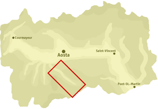
Aosta is the principal city of the Aosta Valley, a bilingual region in the Italian Alps, 110 km (68 mi) north-northwest of Turin. It is situated near the Italian entrance of the Mont Blanc Tunnel and the Great St Bernard Tunnel, at the confluence of the Buthier and the Dora Baltea, and at the junction of the Great and Little St Bernard Pass routes.

Doire was a department of the French First Republic and of the First French Empire in present-day Italy. It was named after the river Dora Baltea. It was formed in 1802, when the Subalpine Republic was directly annexed to France. Its capital was Ivrea.

Monte Rosa is a mountain massif in the eastern part of the Pennine Alps, on the border between Italy and Switzerland (Valais). The highest peak of the massif, amongst several peaks of over 4,000 m (13,000 ft), is the Dufourspitze, the second highest mountain in the Alps and western Europe, after Mont Blanc. The east face of the Monte Rosa towards Italy has a height of about 2,400 metres (7,900 ft) and is the highest mountain wall of the Alps.

Dora Baltea or Doire Baltée is a river in northwestern Italy. It is a left-hand tributary of the Po and is about 170 kilometres (110 mi) long.

Saint-Nicolas is a town and comune in the autonomous region of Aosta Valley, in northern Italy. It consists of 13 hamlets located between 950 and 1,550 metres above sea level. Sitting like a balcony above the Dora Baltea Valley, Saint-Nicolas overlooks the four major lateral valleys of the mid-upper Aosta valley. These are ; Val de Cogne, Valsavarenche, Val de Rhêmes, and Valgrisenche.

Bionaz is a comune sparso which extends over 143 square kilometres (55 sq mi) of the North-Eastern Valpelline area of the Aosta Valley region of northwest Italy. The commune lies on the left side of the river Dora Baltea. The population of about 240 is dispersed among 20 or more small alpine villages and hamlets including Plan-de-Veyne, which is the main centre and the capoluogo. The commune belongs to the Unité des communes valdôtaines du Grand-Combin.

Pont-Saint-Martin ; Piedmontese: Pont San Martìn) is a town and comune in the Aosta Valley region of northwest Italy.

The Lys is a small 40 kilometres (25 mi) river.

Val Ferret is the name shared by two valleys separated by the Col Ferret, a pass on the border between Italy and Switzerland. The valleys lie southeast of Mont Blanc Massif. The Swiss valley drains northeast towards Orsières and on into the Rhône basin; whereas the Italian valley drains southwest towards Courmayeur and on into the Po basin.

The Pont d'Aël is a Roman aqueduct located in a village of the same name in the comune of Aymavilles in Aosta Valley, northern Italy. It was built in the year 3BC for irrigation purposes and supplying water for the newly founded colony of Augusta Praetoria, which is now known as Aosta. The water was directed through a neighbouring valley 66 m above the floor of the Aosta valley, through a sophisticated system. The aqueduct is 6 km long in total. In addition to its unusual position, the construction, which was originally thought to be a three-story structure, shows more unique features such as a control corridor below the water line, as well as explicit private funding. Today, the water channel of the aqueduct serves as a public walking trail.
Val di Cogne (Italian) or Val de Cogne (French) - literally Cogne Valley - is a valley in the Aosta Valley, northern Italy.

The Valdigne is the upper part of the Aosta Valley in north-west Italy. It is traversed by the Dora Baltea, a tributary of the Po.

The Chiusella valley is a valley in the Province of Turin.
The Theodul Glacier is a glacier of the Alps, located south of Zermatt in the canton of Valais. It lies on the Swiss side of the Pennine Alps, although its upper basin touches the Italian region of the Aosta Valley. The glacier descends from the west side of the Breithorn and splits into two diverging branches above Gandegg: the Upper Theodul Glacier, spilling on a high plateau near Trockener Steg, together with the Furgg Glacier, and the Lower Theodul Glacier, reaching a height of about 2,500 metres (8,202 ft) above the Gorner Glacier.

Châtel-Argent was an Italian medieval castle in the Alpine town of Villeneuve. It is now a ruin. As with many other castles in the region, Châtel-Argent overlooks the Dora Baltea River which runs through the Aosta Valley.

The Brenva Glacier is a valley glacier, located on the southern side of the Mont Blanc massif in the Alps. It is the second longest and eighth largest glacier in Italy, and descends down into Val Veny, close to Entrèves, near Courmayeur. Over the centuries it has experienced a number of major rock avalanches which have shaped the glacier and influenced its movement.
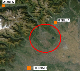
The Ivrea Morainic Amphitheatre is a moraine relief of glacial origin located in the Canavese region. Administratively, it encompasses the metropolitan city of Turin and, more marginally, the province of Biella and the province of Vercelli. It dates back to the Quaternary period and was created by the transport of sediment to the Po Valley that took place during the glaciations by the great glacier that ran through the Dora Baltea valley. With an area of more than 500 km2, it is one of the best-preserved geomorphological units of this type in the world. As an extension, it is surpassed in Italy only by the similar formation surrounding Lake Garda. The name amphitheater, usually given to these geomorphological structures, refers to their characteristic elliptical shape that is noticeable when it is shown as a plan on a map.

The Marmore is a stream which flows through the Valtournenche in the Aosta Valley, Italy. It is a tributary of the Dora Baltea.


![The Buthier flows into the Place-Moulin Lake [fr] LagoDiPlaceMoulinJuly242024 05.jpg](http://upload.wikimedia.org/wikipedia/commons/thumb/4/44/LagoDiPlaceMoulinJuly242024_05.jpg/260px-LagoDiPlaceMoulinJuly242024_05.jpg)