
Mars 96 was a failed Mars mission launched in 1996 to investigate Mars by the Russian Space Forces and not directly related to the Soviet Mars probe program of the same name. After failure of the second fourth-stage burn, the probe assembly re-entered the Earth's atmosphere, breaking up over a 320 km (200 mi) long portion of the Pacific Ocean, Chile, and Bolivia. The Mars 96 spacecraft was based on the Phobos probes launched to Mars in 1988. They were of a new design at the time and both ultimately failed. For the Mars 96 mission the designers believed they had corrected the flaws of the Phobos probes, but the value of their improvements was never demonstrated due to the destruction of the probe during the launch phase.

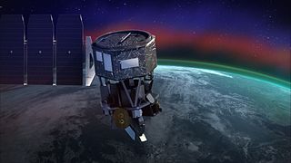
IMAGE is a NASA Medium Explorer mission that studied the global response of the Earth's magnetosphere to changes in the solar wind. It was believed lost but as of August 2018 might be recoverable. It was launched 25 March 2000, at 20:34:43.929 UTC, by a Delta II launch vehicle from Vandenberg Air Force Base on a two-year mission. Almost six years later, it unexpectedly ceased operations in December 2005 during its extended mission and was declared lost. The spacecraft was part of NASA's Sun-Earth Connections Program, and its data has been used in over 400 research articles published in peer-reviewed journals. It had special cameras that provided various breakthroughs in understanding the dynamics of plasma around the Earth. The principal investigator was Jim Burch of the Southwest Research Institute.

Explorer 32, also known as Atmosphere Explorer-B (AE-B), was a NASA satellite launched by the United States to study the Earth's upper atmosphere. It was launched from Cape Canaveral on a Delta C1 launch vehicle, on 25 May 1966. It was the second of five "Atmosphere Explorer", the first being Explorer 17. Though it was placed in a higher-than-expected orbit by a malfunctioning second stage on its launch vehicle, Explorer 32 returned data for ten months before failing due to a sudden depressurization. The satellite reentered the Earth's atmosphere on 22 February 1985.

Cluster II is a space mission of the European Space Agency, with NASA participation, to study the Earth's magnetosphere over the course of nearly two solar cycles. The mission is composed of four identical spacecraft flying in a tetrahedral formation. As a replacement for the original Cluster spacecraft which were lost in a launch failure in 1996, the four Cluster II spacecraft were successfully launched in pairs in July and August 2000 onboard two Soyuz-Fregat rockets from Baikonur, Kazakhstan. In February 2011, Cluster II celebrated 10 years of successful scientific operations in space. In February 2021, Cluster II celebrated 20 years of successful scientific operations in space. As of March 2023, its mission has been extended until September 2024. The China National Space Administration/ESA Double Star mission operated alongside Cluster II from 2004 to 2007.

The Global Geospace Science (GGS) Wind satellite is a NASA science spacecraft designed to study radio waves and plasma that occur in the solar wind and in the Earth's magnetosphere. It was launched on 1 November 1994, at 09:31:00 UTC, from launch pad LC-17B at Cape Canaveral Air Force Station (CCAFS) in Merritt Island, Florida, aboard a McDonnell Douglas Delta II 7925-10 rocket. Wind was designed and manufactured by Martin Marietta Astro Space Division in East Windsor Township, New Jersey. The satellite is a spin-stabilized cylindrical satellite with a diameter of 2.4 m and a height of 1.8 m.

Explorer 17 was a NASA satellite, launched at Cape Canaveral from LC-17B on a Delta B launch vehicle, on 3 April 1963, at 02:00:02 GMT, to study the Earth's upper atmosphere. It was the first satellite of five "Atmosphere Explorer".

The Fast Auroral SnapshoT Explorer was a NASA plasma physics satellite, and was the second spacecraft in the Small Explorer program (SMEX). It was launched on 21 August 1996, from Vandenberg Air Force Base aboard a Pegasus XL launch vehicle. The spacecraft was designed and built by NASA's Goddard Space Flight Center (GSFC). Flight operations were handled by GSFC for the first three years, and thereafter were transferred to the University of California, Berkeley's Space Sciences Laboratory.
Dynamics Explorer was a NASA mission, launched on 3 August 1981, and terminated on 28 February 1991. It consisted of two unmanned satellites, DE-1 and DE-2, whose purpose was to investigate the interactions between plasmas in the magnetosphere and those in the ionosphere. The two satellites were launched together into polar coplanar orbits, which allowed them to simultaneously observe the upper and lower parts of the atmosphere.

MAVEN is a NASA spacecraft orbiting Mars to study the loss of that planet's atmospheric gases to space, providing insight into the history of the planet's climate and water. The name is an acronym for "Mars Atmosphere and Volatile Evolution" while the word maven also denotes "a person who has special knowledge or experience; an expert". MAVEN was launched on an Atlas V rocket from Cape Canaveral Air Force Station, Florida, on 18 November 2013 UTC and went into orbit around Mars on 22 September 2014 UTC. The mission is the first by NASA to study the Mars atmosphere. The probe is analyzing the planet's upper atmosphere and ionosphere to examine how and at what rate the solar wind is stripping away volatile compounds.

Explorer 54, also called as AE-D, was a NASA scientific satellite belonging to series Atmosphere Explorer, being launched on 6 October 1975 from Vandenberg Air Force Base board a Thor-Delta 2910 launch vehicle.
Satya Prakash is an Indian plasma physicist and a former senior professor at the Physical Research Laboratory. He is known for his studies on Langmuir probes and other contributions in space and plasma sciences. A protégé of Vikram Sarabhai, Satya Prakash is an elected fellow of all the three major Indian science academies such as Indian Academy of Sciences, Indian National Science Academy and National Academy of Sciences, India as well as the Gujarat Science Academy and is a recipient of the Hari Om Ashram Prerit Senior Scientist Award. The Government of India honored him with Padma Shri, the fourth highest Indian civilian award for his contributions to the discipline of Physics, in 1982.

Fast, Affordable, Science and Technology Satellite-Huntsville 01 or FASTSAT-Huntsville 01 of the NASA. FASTSAT-HSV 01 was flying on the STP-S26 mission - a joint activity between NASA and the U.S. Department of Defense Space Test Program, or DoD STP. FASTSAT and all of its six experiments flying on the STP-S26 multi-spacecraft/payload mission have been approved by the Department of Defense Space and Experiments Review Board (USA-220).
Ionospheric Connection Explorer (ICON) is a satellite designed to investigate changes in the ionosphere of Earth, the dynamic region high in our atmosphere where terrestrial weather from below meets space weather from above. ICON studies the interaction between Earth's weather systems and space weather driven by the Sun, and how this interaction drives turbulence in the upper atmosphere. It is hoped that a better understanding of this dynamic will mitigate its effects on communications, GPS signals, and technology in general. It is part of NASA's Explorer program and is operated by University of California, Berkeley's Space Sciences Laboratory.

The ISEE-1 was an Explorer-class mother spacecraft, International Sun-Earth Explorer-1, was part of the mother/daughter/heliocentric mission. ISEE-1 was a 340.2 kg (750 lb) space probe used to study magnetic fields near the Earth. ISEE-1 was a spin-stabilized spacecraft and based on the design of the prior IMP series of spacecraft. ISEE-1 and ISEE-2 were launched on 22 October 1977, and they re-entered on 26 September 1987.

Explorer 20, also known Ionosphere Explorer-A, IE-A, S-48, TOPSI and Topside Explorer, was a NASA satellite launched as part of Explorer program. Its purpose was two-fold: long-term investigation of the ionosphere from above, and in situ investigation of ion concentrations and temperatures.

Explorer 22 was a small NASA ionospheric research satellite launched 9 October 1964, part of NASA's Explorer Program. It was instrumented with an electrostatic probe, four radio beacons for ionospheric research, a passive laser tracking reflector, and two radio beacons for Doppler navigation experiments. Its objective was to provide enhanced geodetic measurements of the Earth as well as data on the total electron content in the Earth's atmosphere and in the satellite's immediate vicinity.
Explorer 31, also called DME-A, was a NASA satellite launched as part of the Explorer program. Explorer 31 was launched on 29 November 1965 from Vandenberg Air Force Base, California, with a Thor-Agena launch vehicle. Explorer 31 was released along with the Canadian satellite Alouette 2.

Explorer 51, also called as AE-C, was a NASA scientific satellite belonging to series Atmosphere Explorer, being launched on 16 December 1973, at 06:18:00 UTC, from Vandenberg board a Delta 1900 launch vehicle.
Explorer 55, also called as AE-E, was a NASA scientific satellite belonging to series Atmosphere Explorer, being launched on 20 November 1975 from Cape Canaveral Air Force Station (CCAFS) board a Thor-Delta 2910 launch vehicle.

Dynamics Explorer 2 was a NASA low-altitude mission, launched on 3 August 1981. It consisted of two satellites, DE-1 and DE-2, whose purpose was to investigate the interactions between plasmas in the magnetosphere and those in the ionosphere. The two satellites were launched together into polar coplanar orbits, which allowed them to simultaneously observe the upper and lower parts of the atmosphere.

