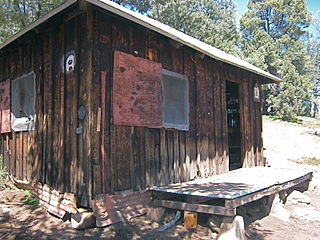
Cabin Cove, California is a small and historic community located in the Sierra Nevada and Sequoia National Forest, within Tulare County, California.

Cabin Cove, California is a small and historic community located in the Sierra Nevada and Sequoia National Forest, within Tulare County, California.
Sequoia National Park surrounds the summer cabins in Cabin Cove. It is on the Mineral King Road, about 20 miles east of the town of Three Rivers, and about 5 miles west of Mineral King.
Cabin Cove is accessible via the Mineral King Road usually between the months of May and November, when the road is not obstructed by snow.
Coordinates: 36°27′56″N118°39′14″W / 36.46556°N 118.65389°W
| This Tulare County, California-related article is a stub. You can help Wikipedia by expanding it. |

Sequoia National Park is an American national park in the southern Sierra Nevada east of Visalia, California. The park was established on September 25, 1890 to protect 404,064 acres of forested mountainous terrain. Encompassing a vertical relief of nearly 13,000 feet (4,000 m), the park contains the highest point in the contiguous United States, Mount Whitney, at 14,505 feet (4,421 m) above sea level. The park is south of, and contiguous with, Kings Canyon National Park; both parks are administered by the National Park Service together as the Sequoia and Kings Canyon National Parks. UNESCO designated the areas as Sequoia-Kings Canyon Biosphere Reserve in 1976.

Calaveras Big Trees State Park is a state park of California, United States, preserving two groves of giant sequoia trees. It is located 4 miles (6.4 km) northeast of Arnold, California in the middle elevations of the Sierra Nevada. It has been a major tourist attraction since 1852, when the existence of the trees was first widely reported, and is considered the longest continuously operated tourist facility in California.
Sawtooth Range, Sawtooth Ridge, and Sawtooth Mountains may refer to:

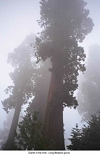
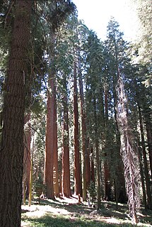
Sequoia National Forest is located in the southern Sierra Nevada mountains of California. The U.S. National Forest is named for the majestic Giant Sequoia trees which populate 38 distinct groves within the boundaries of the forest.

Mineral King is a subalpine glacial valley located in the southern part of Sequoia National Park, in the U.S. state of California. The valley lies at the headwaters of the East Fork of the Kaweah River, which rises at the eastern part of the valley and flows northwest. Accessed by a long and narrow winding road, the valley is mostly popular with backpackers and hikers.

The Kaweah Colony was a utopian socialist community in central California founded in 1886, with a name meaning "here we rest." Located in the Sierra Nevada range, they lived near groves of giant sequoia trees. The colony officially disbanded in 1892. The establishment of Sequoia National Park in 1890 contributed to the colony's demise. Some of their descendants still reside in the area.

The Giant Forest, famed for its giant sequoia trees, is within the United States' Sequoia National Park. This montane forest, situated at over 6,000 feet (1,800 m) above mean sea level in the western Sierra Nevada of California, covers an area of 1,880 acres (7.6 km2). The Giant Forest is the most accessible of all giant sequoia groves, as it has over 40 miles (64 km) of hiking trails.

Converse Basin Grove is a grove of giant sequoia trees located in the Giant Sequoia National Monument in the Sierra Nevada, in Fresno County, California. The grove is situated 5 miles (8 km) north of General Grant Grove, just outside Kings Canyon National Park in the national monument managed by the Sequoia National Forest. The grove is about 3,700 acres (15 km2) with sequoias concentrated in the basin formed by Converse Creek.

Mountain Home Grove is a grove of Giant Sequoia trees that is located in the southern part of the Sierra Nevada Mountains of California, and includes some of the largest trees in the world.

Atwell Mill Grove is a giant sequoia grove in the east fork of the Kaweah watershed area in California. Can be accessed via the Mineral King Road which branches off California State Route 198 below the south entrance to Sequoia National Park.

Muir Grove is a giant sequoia grove in Sequoia National Park of the Tulare County, which covers about 215 acres (0.87 km2). The grove, located in the northwest corner of the park, is accessed by the Muir Grove Trail which begins from the Dorst Creek Campground. Because of its relatively remote location in the park, it is significantly less visited than the more popular groves of large sequoia trees in the park. The isolated atmosphere helps keep Muir Grove untouched and preserved.

The Boole Tree is a giant sequoia in the Converse Basin Grove of Giant Sequoia National Monument, in the Sierra Nevada, in Fresno County, California.

Hume is an unincorporated community in Fresno County, California. It is located 50 miles (80 km) east of Fresno, at an elevation of 5344 feet. Hume is located in the 93628 ZIP Code, in area code 559.

Silver City is a census-designated place (CDP) in the mountainous area of central Tulare County, California. Silver City sits at an elevation of 6,732 feet (2,052 m). It lies 72 km ENE of Visalia, California, within the boundary of Sequoia National Park. The 2010 United States census reported Silver City was uninhabited.

McIver's Cabin is a popular destination for off-road enthusiasts and serves as a shelter for hikers of the Pacific Crest Trail (PCT). It is located at about 6690 ft. near the Kiavah Wilderness, in the Scodie Mountains area of the Sequoia National Forest near the PCT and at the end of the McIver 4X4 road part of forest service road 27S11. It was purchased in 1938 by Murdo George McIver and moved from Sand Canyon, where it was used in building the Los Angeles Aqueduct, to its present location. Miner McIver chose the location due to its proximity to his mining claim and a source of natural spring water, later named McIver's Spring. McIver was born January 05, 1893 in Hoople, North Dakota and died May 11, 1981 in Bakersfield, CA.

Doughton Park is the largest recreation area the National Park Service manages on the Blue Ridge Parkway. It is located between mile markers 238.5 - 244.7 and at 36° 30' 59.0394" N, -81° 8' 40.92" W. The park is named after North Carolina politician Robert L. Doughton.
Golden Trout Creek is an approximately 9-mile (14 km) long tributary of the Kern River, flowing in northeastern Tulare County, California.

The East Fork Kaweah River is a 22.5-mile (36.2 km) tributary of the Kaweah River in Tulare County, California. The river begins below Farewell Gap at the head of the Mineral King Valley in Sequoia National Park. It flows north through mountain meadows then turns west through a steep canyon, where it forms a waterfall about 200 feet (61 m) high known alternately as "Mineral King Falls" or "Three-Falls-Below-The-Gate". It then receives its largest tributary, Horse Creek, from the left before leaving the national park and turning northwest. It joins the Kaweah River about 2 miles (3.2 km) upstream of Three Rivers.
Diamond is a giant sequoia located within the Atwell Mill Grove of Sequoia National Park, California. Naturalists Dennis Coggins, Wendell D. Flint, and Michael M. Law named the tree "Diamond" after the large diamond-shaped scar present on the southeast side of the trunk. It is the largest tree in Atwell Mill Grove, the 20th largest giant sequoia in the world, and could be considered the 19th largest depending on how badly Ishi Giant atrophied during the Rough Fire in 2015.

Above Diamond, also known by the abbreviation AD, is a giant sequoia located within the Atwell Mill Grove of Sequoia National Park, California. Naturalists Dennis Coggins, Wendell D. Flint, and Michael M. Law named the tree "Above Diamond" after Diamond, a giant sequoia located just downhill from the tree. It is the second largest tree in Atwell Mill Grove, the 24th largest giant sequoia in the world, and could be considered the 23rd largest depending on how badly Ishi Giant atrophied during the Rough Fire in 2015.