Cape Finisterre is a rock-bound peninsula on the west coast of Galicia, Spain.

Peniche is a seaside municipality and a city in the Oeste region, in the historical province of Estremadura, and in the Leiria District. It has 26,431 inhabitants, in an area of 77.55 km2. The city itself has a population of about 15,600 inhabitants. The present mayor is Henrique Bertino, elected by the independent coalition GCEPP. The idiomatic expression Friend from Peniche, used to describe someone who wants to receive things at the expense of other without giving anything in return, comes from here.
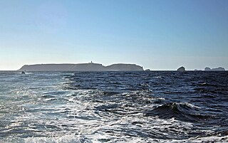
The Berlengas are a Portuguese archipelago consisting of small Atlantic islands 10 to 17 kilometres off the coast of Peniche, Portugal, in the Oeste region. These islands were traditionally known to British mariners as "the Burlings". The only inhabited island is its largest island, Berlenga Grande, although there is currently no permanent habitation in the archipelago. The other islands are grouped into two groups of islets, the Estelas Islets and the Farilhões-Forcados Islets.

Cabo da Roca or Cape Roca is a cape which forms the westernmost point of the Sintra Mountain Range, of mainland Portugal, of continental Europe, and of the Eurasian landmass. It is situated in the municipality of Sintra, near Azóia, in the south west of the Lisbon District. Notably, the point includes a lighthouse that started operation in 1772.

Cape Race is a point of land located at the southeastern tip of the Avalon Peninsula on the island of Newfoundland, in Newfoundland and Labrador, Canada. Its name is thought to come from the original Portuguese name for this cape, "Raso", meaning flat or low-lying. The Cape appeared on early sixteenth century maps as Cabo Raso and its name may derive from a cape of the same name at the mouth of the Tagus River in Portugal. The cape was the location of the Cape Race LORAN-C transmitter until the system was decommissioned in 2010. It is also home to the Cape Race Lighthouse, notable for having received the distress call from the RMS Titanic.
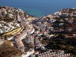
Carvoeiro is a town and a former civil parish in the municipality (concelho) of Lagoa, Algarve, Portugal. In 2013, the parish merged into the new parish Lagoa e Carvoeiro. The population in 2011 was 2,721, in an area of 11.66 km². It is located about 5 kilometres (3.1 mi) south of Lagoa.
Nossa Senhora do Rosário is a freguesia of Cape Verde. It covers the larger eastern part of the municipality of Ribeira Brava, on the island of São Nicolau.
Carvoeiros is a settlement in the northern region of the island on São Nicolau, Cape Verde. It is situated on the north coast of São Nicolau, 2 km east of Queimadas and 4 km north of Ribeira Brava.

Cape Espichel is a cape situated on the western coast of the civil parish of Castelo, municipality of Sesimbra, in the Portuguese district of Setúbal, at the very southwestern corner of the Setubal Peninsula. It is characterized by a very acute protrusion of the coastline into the Atlantic Ocean, and it consists of a promontory plateau, over 130 meters above sea level, defined by dramatic, sheer cliffs all around the delimitation of the cape against the ocean.
The location offers elevated sweeping views, from Cascais and the Sintra Mountains, and the Caparica coast to the north, and to the southeast the beaches south of Tróia and beyond to Sines.
Cape Espichel is part of the Espichel Special Protection Zone, the Arrábida / Espichel Special Conservation Zone, and the Arrábida Natural Park.

Porto Novo is a city in the island of Santo Antão, in Cape Verde. It is the seat of the Porto Novo municipality. At the 2010 census, the town had 9,310 inhabitants, which makes it the most populous settlement of the island.

Cape Palos is a cape in the Spanish municipality of Cartagena, in the region of Murcia. It is part of a small range of volcanic mounts that form a small peninsula. The Mediterranean islands of Grosa and the group known as the Hormigas Islands are part of this range, as well as the islands in the Mar Menor. The name Palos is derived from the Latin word palus, meaning ‘lagoon’, a reference to the Mar Menor.

Cape Bojeador Lighthouse, also known as Burgos Lighthouse, is a cultural heritage structure in Burgos, Ilocos Norte, that was established during the Spanish colonial period in the Philippines. The lighthouse was first lit on March 30, 1892, and is set high on Vigia de Nagpartian Hill overlooking the scenic Cape Bojeador where early galleons used to sail by. After over 100 years, it still functions and serves ships that enter the Philippine archipelago from the north and guide them safely away from the rocky coast of the town.

Cape Engaño Lighthouse, also known as Faro de Cabo Engaño, is a historic lighthouse located at Cape Engaño on Palaui Island in the town of Santa Ana, the province of Cagayan, Philippines. Located at the northernmost part of Luzon Island and situated atop the summit of a hill, 92 meters above sea level, the lighthouse provides a 360-degree view of Babuyan Island and the Dos Hermanas Island on the North, Pacific Ocean on the West and Engaño cove on the East.
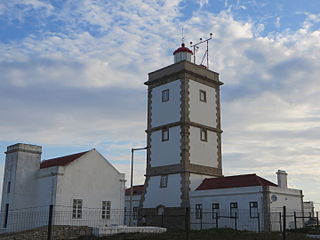
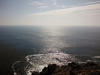
The Lighthouse of Cabo Carvoeiro is an active lighthouse in the civil parish of Peniche, municipality of the same name, in the Portuguese district of Leiria.

Furninha, also known as Dominique's cave, is a natural cave on the southern slope of the Peniche peninsula in Portugal. The cave is situated on the cliffs between the Peniche Fortress and the Cape Carvoeiro. The cave is located furthest west of any Neanderthal site. Neanderthals became extinct over 40,000 years ago. The cave was also inhabited by modern humans during the Neolithic.

Cape Santiago Lighthouse, also known as Faro de Cabo Santiago, is a historic lighthouse located about 130 kilometres (81 mi) southwest of Manila in Barangay Bagong Silang, Calatagan, Batangas, Philippines. It is the oldest working lighthouse in Batangas and one of the oldest working lighthouses in the Philippines. It serves as a guide for ships passing through the Verde Island Passage and entering Manila Bay.

Berlenga lighthouse, also known as the Duke of Bragança Lighthouse, is a functioning lighthouse situated on the highest point of the granite island of Berlenga Grande, which is a nature reserve in the Atlantic Ocean, 10 kilometres west of the town of Peniche in the Leiria District of Portugal. Although planned for construction in the 18th century, work did not start until 1837 and it was completed in 1842.

The Directorate of Lighthouses in Portugal is responsible for managing the country's 47 lighthouses, as well as other marine navigation activities. It is headquartered in Paço de Arcos.