Conemaugh Township is a township in Somerset County, Pennsylvania, United States. The population was 7,452 at the 2000 census. It is part of the Johnstown, Pennsylvania Metropolitan Statistical Area. Conemaugh Township includes the towns of Jerome, Davidsville, Tire Hill, Thomas Mills, part of Holsopple, and surrounding countryside.

Quemahoning Township is a township in Somerset County, Pennsylvania, United States. The population was 2,180 at the 2000 census. It is part of the Johnstown, Pennsylvania Metropolitan Statistical Area.

Cabo San Lucas, or simply Cabo, is a resort city at the southern tip of the Baja California Peninsula, in the Mexican state of Baja California Sur. As of 2015, the population of the city was 81,111 inhabitants. Cabo San Lucas together with San José del Cabo is known as Los Cabos. Together they form a metropolitan area of 305,983 inhabitants.

Darién is a province in Panama whose capital city is La Palma. With an area of 11,896.5 km2 (4,593.3 sq mi), it is located at the eastern end of the country and bordered to the north by the province of Panamá and the region of Kuna Yala. To the south, it is bordered by the Pacific Ocean and Colombia. To the east, it borders Colombia; to the west, it borders the Pacific Ocean and the province of Panama.
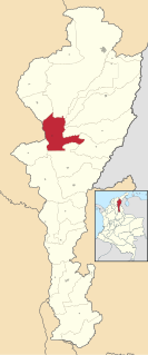
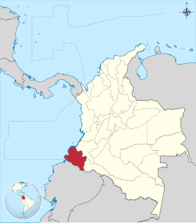
El Paso is a municipality in the Cesar Department of Colombia. El Paso is mostly known for having the second largest coal mine in Colombia, located in the corregimiento of La Loma.
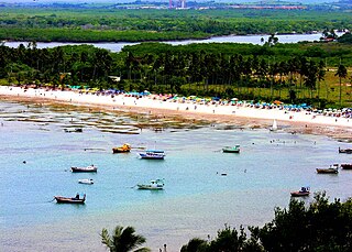
Cabo de Santo Agostinho is 35 km south of the city of Recife, Pernambuco, Brazil. Although the official Portuguese discovery of Brazil was by Pedro Álvares Cabral on April 21, 1500, some historians believe that Vicente Yáñez Pinzón already had set anchor in a bay in Cabo de Santo Agostinho on January 26, 1500, which he named Cabo de Santa María de la Consolación. It was incorporated as a town in 1811.

San Rafael del Yuma is a municipality of approximately 46,687 people in 2012, located in the La Altagracia province of the Dominican Republic. The ruins of Juan Ponce de León's residence are located on a plateau located three kilometers from San Rafael de Yuma. The municipality is located 10 kilometers from Boca de Yuma.

Manglares de Tumbes National Sanctuary is a protected natural area located in the region of Tumbes, Peru. Established in 1988, it protects the largest area of mangrove forest in Peru.

Praia de Atalanta is a beach on the north coast of the island of Boa Vista in Cape Verde. It is approximately 6 km northeast of the island capital of Sal Rei and 3 km west of Vigía. The wreck of the Spanish cargo ship Cabo Santa Maria, which ran aground on September 1, 1968, is located here.

WBSM is an AM radio station broadcasting in the New Bedford/Fall River market area with a News/Talk/Sports format. It broadcasts on 1420 kilohertz and is under ownership of Townsquare Media, with studios in Fairhaven shared with WFHN.
Consaca is a town and municipality in the Nariño Department, Colombia. It is a town and municipality of Nariño Colombia, and has 12.639 inhabitants. Consaca is located near the Galeras Volcano and is 54 Kilometers away by car from the city San Juan de Pasto. Consaca is known by the name "Historical corner of Colombia".
Federal Highway 1D is a tolled part of the Mexico Federal Highways, paralleling Fed. 1. There are two segments, one in the state of Baja California and another in the state of Baja California Sur.

The contribution of travel and tourism to GDP was USD5,880.3bn in 2016. Tourism generated 556,135 jobs in 2016. Foreign tourist visits were predicted to have risen from 0.6 million in 2007 to 4 million in 2017. Responsible tourism became a peremptory need for Colombia because minimizes negative social, economic and environmental impacts and makes positive contributions to the conservation of natural and cultural heritage.

Ventarrón is the site of a 4,500-year-old temple with painted murals, which was excavated in Peru in 2007 near Chiclayo, in the Lambayeque region on the northern coast. The site was inhabited by the Early Cupisnique, Cupisnique, Chavin and Moche cultures.
Terebutenets is a rural locality under the administrative jurisdiction of the Urban-Type Settlement of Nebolchi in Lyubytinsky District of Novgorod Oblast, Russia, located approximately 215 kilometers (134 mi) east-southeast of Saint Petersburg, 430 kilometers (270 mi) northwest of Moscow, and about 20 kilometers (12 mi) southeast of Nebolchi.
This is a list of the extreme points of Colombia, the points that are farther north, south, east or west than any other location.

The 1979 Tumaco earthquake occurred at 02:59 local time on 12 December with a moment magnitude of 8.2 and a maximum Mercalli intensity of IX (Violent). The epicenter was just offshore from the border between Ecuador and Colombia, near the port city of Tumaco. It triggered a major tsunami, which was responsible for most of the estimated 300–600 deaths. The hardest hit area was Colombia's Nariño Department.
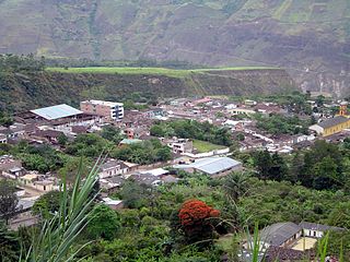
Miraflores is a small town in the Municipality of Los Cabos. Miraflores is located about 45 miles north of San Jose del Cabo, 2 km west of Highway 1, just to the east of the Sierra de la Laguna. Miraflores is 220 meters above sea level. As of 2010, the town had a population of 1,384.

Fairfax is an unincorporated community in Clear Creek Township, Monroe County, in the U.S. state of Indiana.