Caliper Lake Provincial Park

Last updated
Caliper Lake Provincial Park
IUCN category II (national park)
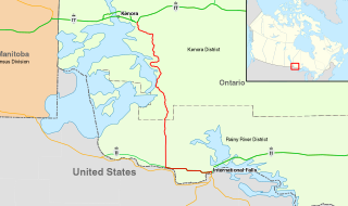
Canada Ontario location map 2.svg
Red pog.svg
Location Ontario, Canada
Nearest city Nestor Falls
Coordinates 49°03′40″N93°54′47″W / 49.061°N 93.913°W / 49.061; -93.913 Coordinates: 49°03′40″N93°54′47″W / 49.061°N 93.913°W / 49.061; -93.913
Area 147 ha (360 acres)
Established 1960 [1]
www.ontarioparks.com/park/caliperlake

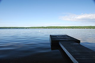
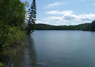
Caliper Lake Provincial Park is a small provincial park in northwestern Ontario, near the township of Nestor Falls. The park occupies 147 hectares (360 acres) alongside Caliper Lake. The facility is open for day use and overnight camping from mid-May to mid-September. The park features 83 campsites, many with electrical hookups, and some which may be rented for the entire season. The park offers many amenities, including a sandy beach, hiking trails, playground equipment, fish cleaning facilities, boat launches, bathrooms, and showers. Canoes, kayaks, and bicycles are available for rental.

Provincial park type of protected area

A provincial park is a park administered by one of the provinces of a country, as opposed to a national park. They are similar to state parks in other countries. They are typically open to the public for recreation. Their environment may be more or less strictly protected. Argentina, Belgium, Canada and South Africa are among the countries that have provincial parks.

Ontario Province of Canada

Ontario is one of the 13 provinces and territories of Canada and is located in east-central Canada. It is Canada's most populous province accounting for 38.3 percent of the country's population, and is the second-largest province in total area. Ontario is fourth-largest jurisdiction in total area when the territories of the Northwest Territories and Nunavut are included. It is home to the nation's capital city, Ottawa, and the nation's most populous city, Toronto, which is also Ontario's provincial capital.

The park is known for its beautiful red and white pine trees. Fish found in the lake include northern pike, walleye, crappie, and smallmouth bass. Pelicans, cranes, ducks, loons, and bald eagles are just some of the birds that can found on the lake.

Fish vertebrate animal that lives in water and (typically) has gills

Fish are gill-bearing aquatic craniate animals that lack limbs with digits. They form a sister group to the tunicates, together forming the olfactores. Included in this definition are the living hagfish, lampreys, and cartilaginous and bony fish as well as various extinct related groups. Tetrapods emerged within lobe-finned fishes, so cladistically they are fish as well. However, traditionally fish are rendered paraphyletic by excluding the tetrapods. Because in this manner the term "fish" is defined negatively as a paraphyletic group, it is not considered a formal taxonomic grouping in systematic biology, unless it is used in the cladistic sense, including tetrapods. The traditional term pisces is considered a typological, but not a phylogenetic classification.

Walleye species of fish

The walleye, also called the yellow pike, is a freshwater perciform fish native to most of Canada and to the Northern United States. It is a North American close relative of the European zander, also known as the pikeperch. The walleye is sometimes called the yellow walleye to distinguish it from the blue walleye, which is a subspecies that was once found in the southern Ontario and Quebec regions, but is now presumed extinct. However, recent genetic analysis of a preserved (frozen) 'blue walleye' sample suggests that the blue and yellow walleye were simply phenotypes within the same species and do not merit separate taxonomic classification.

Pelican A genus of large water birds with a large bill and throat pouch

Pelicans are a genus of large water birds that make up the family Pelecanidae. They are characterised by a long beak and a large throat pouch used for catching prey and draining water from the scooped-up contents before swallowing. They have predominantly pale plumage, the exceptions being the brown and Peruvian pelicans. The bills, pouches, and bare facial skin of all species become brightly coloured before the breeding season. The eight living pelican species have a patchy global distribution, ranging latitudinally from the tropics to the temperate zone, though they are absent from interior South America and from polar regions and the open ocean.

The park was closed for overnight camping in 2013 by the Ontario Ministry of Natural Resources. The township of Sioux Narrows-Nestor Falls reached an agreement with the Ministry of Natural Resources for the township to assume operation of the park. [2]

Related Research Articles

Lake of the Woods lake occupying parts of the Canadian provinces of Ontario and Manitoba and the U.S. state of Minnesota

Lake of the Woods is a lake occupying parts of the Canadian provinces of Ontario and Manitoba and the U.S. state of Minnesota. It separates a small land area of Minnesota from the rest of the United States. The Northwest Angle and the town of Angle Township can be reached from the rest of Minnesota only by crossing the lake or by traveling through Canada. The Northwest Angle is the northernmost part of the contiguous United States. Its "northwesternmost point" served as a problematic landmark in treaties defining the international border.

Madawaska River (Ontario) river in Ontario, Canada

The Madawaska River is a river in the Saint Lawrence River drainage basin in Ontario, Canada. The river is 230 km (143 mi) long and drains an area of 8,470 km2 (3,270 sq mi). Its name comes from an Algonquian band of the region known as "Matouweskarini", meaning "people of the shallows".

Lake Nipissing lake in Canada

Lake Nipissing is a lake in the Canadian province of Ontario. It has a surface area of 873.3 km2 (337.2 sq mi), a mean elevation of 196 m (643 ft) above sea level, and is located between the Ottawa River and Georgian Bay. Lake Nipissing is the third-largest lake entirely in Ontario. It is relatively shallow for a large lake, with an average depth of only 4.5 m (15 ft). The shallowness of the lake makes for many sandbars along the lake's irregular shoreline. The lake reaches a maximum depth of 64 m near the mouth of the French River, off the shore of Blueberry Island. The lake has many islands most of which are protected under the Protection of Significant Wetlands scheme, controlled by the Ministry of Natural Resources and Forestry.

York River (Ontario) river in Canada

The York River is a river in Renfrew County, Hastings County and Haliburton County in Ontario, Canada. The river is in the Saint Lawrence River drainage basin, and flows from the southern extension of Algonquin Provincial Park to the Madawaska River.

Sand River (Ontario) river in Ontario, Canada

The Sand River is a river in the Unorganized North Part of Algoma District in Northeastern Ontario, Canada. It is in the Great Lakes Basin, is a tributary of Lake Superior, and its entire course lies within Lake Superior Provincial Park.

Opeongo Lake lake in Nipissing District, Ontario, Canada

Opeongo Lake is a lake in the Saint Lawrence River drainage basin in the geographic townships of Bower, Dickson, Preston and Sproule in the Unorganized South Part of Nipissing District in Northeastern Ontario, Canada. It is the largest lake in Algonquin Provincial Park and the source of the Opeongo River. The lake's name comes from the Algonquian word opeauwingauk meaning "sandy narrows".

Pottageville, Ontario Unincorporated community in Ontario, Canada

Pottageville is an unincorporated community located in northeastern King Township, in Ontario, Canada. It is near Schomberg. It is named for one of its early settlers, Edward Pottage.

Ontario Highway 71 highway in Ontario

King's Highway 71, commonly referred to as Highway 71, is a provincially maintained highway in the Canadian province of Ontario. The 194-kilometre-long (121 mi) route begins at the Fort Frances–International Falls International Bridge in Fort Frances, continuing from US Route 53 (US 53) and US Route 71 (US 71) in Minnesota, and travels west concurrently with Highway 11 for 40 kilometres (25 mi) to Chapple. At that point, Highway 11 continues west while Highway 71 branches north and travels 154 kilometres (96 mi) to a junction with Highway 17 just east of Kenora. Highway 71 is part of the Trans-Canada Highway for its entire length.

Batchawana Bay Provincial Park Provincial park in Ontario, Canada

Batchawana Bay Provincial Park is a park in Algoma District, Ontario, Canada, located 40 kilometres (25 mi) from Sault Ste. Marie on Ontario Highway 17, and on Batchawana Bay on Lake Superior. It is a day-park, and is operated by the Ontario Ministry of Natural Resources. The mouth of the Carp River is at the west end of the park.

Sioux Narrows-Nestor Falls Township in Ontario, Canada

Sioux Narrows-Nestor Falls is a township in the Canadian province of Ontario, located in the Kenora District. It is located on the eastern shores of Lake of the Woods along Ontario Highway 71.

Minnitaki Kames Provincial Park

Minnitaki Kames Provincial Park is a 4,422-hectare (10,930-acre) nature reserve in Ontario, Canada, designated to protect several distinguishing features, including east-west kame ridges and numerous terraces. It abuts the shores of Minnitaki Lake, with the nearest settlement at Sioux Lookout, about 20 km to the north.

Boshkung Lake Lake in Haliburton County, Ontario, Canada

Boshkung Lake, also known by its historic name Lake Boshkung, or affectionately as 'Big Boshkung', is a lake in the township of Algonquin Highlands, Haliburton County in Central Ontario, Canada. It is located near Buttermilk Falls, has been a common cottage and recreation destination with a rich history that includes logging, children's camps, camping, and even some farming activities.

Bull Lake (Black River) lake in Sioux Narrows-Nestor Falls, Ontario, Canada

Bull Lake is a lake in geographic Devonshire Township in the municipality of Sioux Narrows-Nestor Falls, Kenora District, Ontario, Canada. It is about 570 metres (1,870 ft) long and 260 metres (853 ft) wide, and lies at an elevation of 358 metres (1,175 ft) about 15 kilometres (9.3 mi) northeast of the community of Sioux Narrows. The primary outflow is an unnamed creek to Mac Lake, whose waters flow via the Black River into Lake of the Woods.

Kakagi Lake lake in Kenora District, Ontario, Canada

Kakagi Lake, also known as Crow Lake, is a lake in both Unorganized Kenora District and the township of Sioux Narrows-Nestor Falls, Kenora District, in Northwestern Ontario, Canada. It is just north of the community of Nestor Falls, and right across Ontario Highway 71 from Stevens Bay on Lake of the Woods. It also feeds Lake of the Woods through a series of lakes starting with Cedartree Lake.

King's Highway 70, commonly referred to as Highway 70, was a provincially maintained highway in the Canadian province of Ontario, which provided a shorter route from Highway 6 and Highway 21 in Springmount to Highway 6 in Hepworth. The route, which now forms part of Highway 6, was 15.1 kilometres (9.4 mi) long and travelled in a southeast–northwest direction west of Owen Sound. The route followed an early trail blazed by deputy surveyor Charles Rankin in 1842 that was upgraded to a modern road in the 1920s. Highway 70 was designated in 1965 and renumbered as Highway 6 in 1997. Another Highway 70 existed near Kenora between 1937 and 1959 before being renumbered as Highway 71. This designation was applied along the newly opened Heenan Highway, shortly after the Department of Highways (DHO) began numbering routes in northern Ontario. However, a series of renumberings in 1960 led to the entire length becoming part of Highway 71.

Riley Lake (Kenora District)

Riley Lake is a lake in geographic Code Township in the municipality of Sioux Narrows-Nestor Falls, Kenora District in Northwestern Ontario, Canada. It is part of the Hudson Bay drainage basin.

Black River (Kenora District)

The Black River is a river in the municipality of Sioux Narrows-Nestor Falls, Kenora District in Northwestern Ontario, Canada. It is part of the Hudson Bay drainage basin, and is a tributary of the Lake of the Woods.

Black Lake (Sioux Narrows) lake in Sioux Narrows-Nestor Falls, Kenora District, Ontario, Canada

Black Lake is a lake in the municipality of Sioux Narrows-Nestor Falls, Kenora District in Northwestern Ontario, Canada. It is part of the Hudson Bay drainage basin, and is on the Black River, which is its primary inflow at the east and outflow at the southwest.

Cedartree Lake lake in Canada

Cedartree Lake, is a lake just north of Nestor Falls, Ontario, Canada, in the township of Sioux Narrows-Nestor Falls and is fed by Kakagi Lake. It is also feeds Lake of the Woods through a series of lakes starting with Flint Lake.

Elections were held in the organized municipalities in the Kenora District of Ontario on October 22, 2018 in conjunction with municipal elections across the province.

References

  1. "Caliper Lake Provincial Park - Recreation". ProtectedPlanet. Archived from the original on 25 August 2014.
  2. "Caliper Lake Park to be run by Sioux Narrows-Nestor Falls". CBC.ca . 10 April 2014. Archived from the original on 25 August 2014.