Sources
- Camelford Rural District in Vision of Britain (based on F. Youngs, Local Administrative Units: Southern England. London: Royal Historical Society; p. 63)
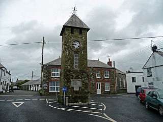
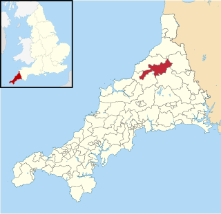
Camelford Rural District was a local government division of north Cornwall between 1894 and 1974. The district council offices were at Camelford, Cornwall, England, UK, latterly in the former grammar school. It was one of several rural districts in Cornwall which carried out some local government functions while those for Cornwall as a whole were the responsibility of the Cornwall County Council.
The following civil parishes were within the district:
Restormel was a borough of Cornwall, England, one of the six administrative divisions that made up the county. Its council was based in St Austell; its other towns included Newquay.
Caradon was a local government district in Cornwall, England, United Kingdom. It contained five towns: Callington, Liskeard, Looe, Saltash and Torpoint, and over 80 villages and hamlets within 41 civil parishes. Its District Council was based in Liskeard 50.453°N 4.465°W.

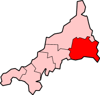
North Cornwall is an area of Cornwall, England, United Kingdom. It is also the name of a former local government district, which was administered from Bodmin and Wadebridge 50.516°N 4.835°W. Other towns in the area are Launceston, Bude, Padstow, and Camelford.

Boscastle is a village and fishing port on the north coast of Cornwall, England, in the civil parish of Forrabury and Minster. It is 14 miles (23 km) south of Bude and 5 miles (8 km) northeast of Tintagel. The harbour is a natural inlet protected by two stone harbour walls built in 1584 by Sir Richard Grenville and is the only significant harbour for 20 miles (32 km) along the coast. The village extends up the valleys of the River Valency and River Jordan. Heavy rainfall on 16 August 2004 caused extensive damage to the village.

North Cornwall is a constituency represented in the House of Commons of the UK Parliament by Ben Maguire, a Liberal Democrat since the 2024 general election. Like all British constituencies, the seat elects one Member of Parliament (MP) by the first past the post system of election at least every five years. The seat was created in 1918. Since 1950, the constituency has been held by MPs from either the Conservative Party or the Liberal Democrats.

The hundreds of Cornwall were administrative divisions or Shires (hundreds) into which Cornwall, the present day administrative county of England, in the United Kingdom, was divided between c. 925 and 1894, when they were replaced with local government districts.
St Teath is a civil parish and village in north Cornwall, England, in the United Kingdom.
Delabole is a large village and civil parish in north Cornwall, England, United Kingdom, which lies approximately two miles (3 km) west of Camelford.

Forrabury and Minster is a civil parish on the north coast of Cornwall, England, United Kingdom. The parish was originally divided between the coastal parish of Forrabury and inland parish of Minster until they were united on the 1st of April 1919.

Lesnewth Hundred is one of the former hundreds of Cornwall, Trigg was to the south-west and Stratton Hundred to the north-east. Tintagel, Camelford, Boscastle, and Altarnun were in the Hundred of Lesnewth as well as Lesnewth which is now a hamlet but in pre-Norman times was the seat of a Celtic chieftain who was said to rule the whole of Trigg.

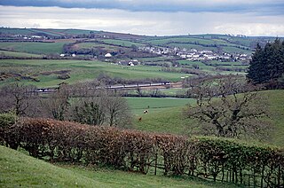
Slaughterbridge, Treague and Camelford Station are three adjoining settlements in north Cornwall, England. They straddle the boundary of Forrabury and Minster and Lanteglos by Camelford civil parishes just over a mile (2 km) north-west of the market town of Camelford.

The River Allen in north Cornwall is one of two rivers in Cornwall which share this name. In this case the name is the result of a mistake made in 1888 by Ordnance Survey, replacing the name Layne with Allen which is the old name for the lower reaches of the Camel. The other River Allen runs through Truro.

The civil parishes to which the Forrabury and Minster parish churches belong were united in 1919 to form Forrabury and Minster parish, within Cornwall, England, UK. The main settlement in the parish is Boscastle. The two rectories had been united in 1800.

A civil parish is a country subdivision, forming the lowest unit of local government in England. There are 218 civil parishes in the ceremonial county of Cornwall, which includes the Isles of Scilly. The county is effectively parished in its entirety; only the unpopulated Wolf Rock is unparished. At the 2001 census, there were 501,267 people living in the current parishes, accounting for the whole of the county's population. The final unparished areas of mainland Cornwall, around St Austell, were parished on 1 April 2009 to coincide with the structural changes to local government in England.

Hendra is the name of eight hamlets in Cornwall, England, United Kingdom.
Treforda is a hamlet in the civil parish of Camelford, Cornwall, England, United Kingdom.
Tintagel was an electoral division of Cornwall which returned one member to sit on Cornwall Council between 2009 and 2021. It was abolished at the 2021 local elections, being succeeded by St Teath and Tintagel and Camelford and Boscastle.

St Teath and St Breward was an electoral division of Cornwall in the United Kingdom which returned one member to sit on Cornwall Council between 2013 and 2021. It was abolished at the 2021 local elections, being succeeded by St Teath and Tintagel.
Camelford was an electoral division of Cornwall in the United Kingdom which returned one member to sit on Cornwall Council between 2009 and 2021. It was abolished at the 2021 local elections, being succeeded by Camelford and Boscastle.

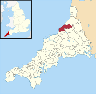
Camelford and Boscastle is an electoral division of Cornwall in the United Kingdom which returns one member to sit on Cornwall Council. It was created at the 2021 local elections, being created from the former divisions of Camelford and Tintagel. The current councillor is Barry Jordan, a member of the Conservative Party.