Campoli Appennino

Last updated
Campoli Appennino
Comune
Comune di Campoli Appennino
La chiesa e la vecchia torre - panoramio.jpg
Campoli Appennino-Stemma.png
Coat of arms
Italy provincial location map 2015.svg
Red pog.svg
Campoli Appennino
Location of Campoli Appennino in Italy
Coordinates: 41°44′N13°41′E / 41.733°N 13.683°E / 41.733; 13.683
Country Italy
Region Lazio
Province Frosinone (FR)
Government
  Mayor Pietro Annunzio Mazzone
Area
  Total 33.4 km2 (12.9 sq mi)
Elevation 650 m (2,130 ft)
Population (28 February 2017) [1]
  Total 1,690
  Density 51/km2 (130/sq mi)
Demonym(s) Campolesi
Time zone CET (UTC+1)
  Summer (DST) CEST (UTC+2)
Postal code03030
Dialing code 0776
Patron saint St. Pancratius
Saint day May 12
Website Official website

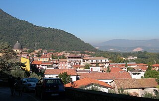
Campoli Appennino (Campanian: Campere) is a comune (municipality) in the Province of Frosinone in the Italian region Lazio, located about 100 kilometres (62 mi) east of Rome and about 30 kilometres (19 mi) northeast of Frosinone.

Neapolitan language Italo-Dalmatian language spoken in Southern Italy

Neapolitan is a Romance language of the Italo-Dalmatian group spoken across much of southern Italy, except for southern Calabria, southern Apulia, and Sicily, as well as in a small part of central Italy. It is not named specifically after the city of Naples, but rather the homonymous Kingdom that once covered most of the area, and of which the city was the capital. On October 14, 2008, a law by the Region of Campania stated that Neapolitan was to be protected. While the term "Neapolitan language" is used in this article to refer to the language group of related dialects found in southern continental Italy, it may also refer more specifically to the dialect of the Neapolitan language spoken in the Naples area or in Campania.

<i>Comune</i> third-level administrative divisions of the Italian Republic

The comune is a basic administrative division in Italy, roughly equivalent to a township or municipality.

Province of Frosinone Province of Italy

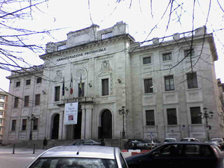
The Province of Frosinone is a province in the Lazio region of Italy, with 91 comuni. Its capital is the city of Frosinone. It has an area of 3,247 square kilometres (1,254 sq mi) and a total population of 493,605 (2016).

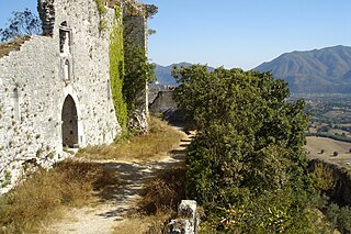
Campoli Appennino borders the following municipalities: Alvito, Broccostella, Pescasseroli, Pescosolido, Posta Fibreno, Sora, Villavallelonga. It is home to a medieval tower, 25 metres (82 ft) high, a series of walls, and the "Aqueduct of Nero".

Alvito, Lazio Comune in Lazio, Italy

Alvito is a town and comune in central Italy, in the province of Frosinone, south of Rome in the Lazio region. Its territory is included in the Abruzzo, Lazio and Molise National Park.

Broccostella Comune in Lazio, Italy

Broccostella is a comune (municipality) in the Province of Frosinone in the Italian region Lazio, located about 100 kilometres (62 mi) east of Rome and about 25 kilometres (16 mi) northeast of Frosinone.

Pescasseroli Comune in Abruzzo, Italy

Pescasseroli is a town and comune in the province of L'Aquila, in Southern Abruzzo, central Italy.

See also

Related Research Articles

Acquafondata Comune in Lazio, Italy

Acquafondata is a comune (municipality) in the Province of Frosinone in the Italian region Lazio, located in the Monti della Meta area, about 130 kilometres (81 mi) southeast of Rome and about 50 kilometres (31 mi) east of Frosinone.

Arnara Comune in Lazio, Italy

Arnara is a comune (municipality) in the Province of Frosinone in the Italian region Lazio, located about 80 kilometres (50 mi) southeast of Rome and about 6 kilometres (4 mi) southeast of Frosinone.

Belmonte Castello Comune in Lazio, Italy

Belmonte Castello is a comune (municipality) in the Province of Frosinone in the Italian region Lazio, located about 120 kilometres (75 mi) southeast of Rome and about 40 kilometres (25 mi) east of Frosinone.

Castrocielo Comune in Lazio, Italy

Castrocielo is a comune (municipality) in the province of Frosinone in the Italian region Lazio, located about 110 kilometres (68 mi) southeast of Rome and about 30 kilometres (19 mi) southeast of Frosinone.

Colfelice Comune in Lazio, Italy

Colfelice is a comune (municipality) in the Province of Frosinone in the Italian region Lazio, located about 100 kilometres (62 mi) southeast of Rome and about 25 kilometres (16 mi) southeast of Frosinone.

Giuliano di Roma Comune in Lazio, Italy

Giuliano di Roma is a comune (municipality) in the province of Frosinone in the Italian region Lazio, located about 80 kilometres (50 mi) southeast of Rome and about 12 kilometres (7 mi) southwest of Frosinone.

Morolo Comune in Lazio, Italy

Morolo is a comune (municipality) in the Province of Frosinone in the Italian region Lazio, located about 70 kilometres (43 mi) southeast of Rome and about 12 kilometres (7 mi) west of Frosinone.

Pastena Comune in Lazio, Italy

Pastena is a comune (municipality) in the Province of Frosinone in the Italian region Lazio, located about 90 kilometres (56 mi) southeast of Rome and about 20 kilometres (12 mi) southeast of Frosinone.

Pescosolido Comune in Lazio, Italy

Pescosolido is a comune (municipality) in the Province of Frosinone in the Italian region Lazio, located about 100 kilometres (62 mi) east of Rome and about 30 kilometres (19 mi) northeast of Frosinone.

Posta Fibreno Comune in Lazio, Italy

Posta Fibreno is a comune (municipality) in the Province of Frosinone in the Italian region Lazio, located about 100 kilometres (62 mi) east of Rome and about 30 kilometres (19 mi) east of Frosinone.

San Giorgio a Liri Comune in Lazio, Italy

San Giorgio a Liri is a comune (municipality) in the Province of Frosinone in the Italian region Lazio, located about 120 kilometres (75 mi) southeast of Rome and about 45 kilometres (28 mi) southeast of Frosinone.

San Vittore del Lazio Comune in Lazio, Italy

San Vittore del Lazio is a comune (municipality) in the Province of Frosinone in the Italian region Lazio, located about 130 kilometres (81 mi) southeast of Rome and about 50 kilometres (31 mi) southeast of Frosinone.

Supino Comune in Lazio, Italy

Supino is a comune (municipality) in the Province of Frosinone in the Italian region Lazio, located about 70 kilometres (43 mi) southeast of Rome and about 10 kilometres (6 mi) west of Frosinone.

Terelle Comune in Lazio, Italy

Terelle is a comune (municipality) in the Province of Frosinone in the Italian region Lazio, located about 110 kilometres (68 mi) southeast of Rome and about 35 kilometres (22 mi) east of Frosinone.

Torrice Comune in Lazio, Italy

Torrice is a comune (municipality) in the Province of Frosinone in the Italian region Lazio, located about 80 kilometres (50 mi) southeast of Rome and about 4 kilometres (2.5 mi) east of Frosinone.

Trivigliano Comune in Lazio, Italy

Trivigliano is a comune (municipality) in the Province of Frosinone in the Italian region Lazio, located about 60 kilometres (37 mi) east of Rome and about 20 kilometres (12 mi) northwest of Frosinone, in the Monti Ernici area

Vico nel Lazio Comune in Lazio, Italy

Vico nel Lazio is a comune (municipality) in the Province of Frosinone in the Italian region Lazio, located about 70 kilometres (43 mi) east of Rome and about 15 kilometres (9 mi) north of Frosinone.

Villa Latina Comune in Lazio, Italy

Villa Latina is a comune (municipality) in the Province of Frosinone in the Italian region Lazio, located about 120 kilometres (75 mi) southeast of Rome and about 40 kilometres (25 mi) east of Frosinone.

Viticuso Comune in Lazio, Italy

Viticuso is a comune (municipality) in the Province of Frosinone in the Italian region Lazio, located about 130 kilometres (81 mi) southeast of Rome and about 50 kilometres (31 mi) east of Frosinone.

References

  1. All demographics and other statistics: Italian statistical institute Istat.