
Smiths Falls is a town in Eastern Ontario, Canada, 72 kilometres (45 mi) southwest of Ottawa. As of the 2021 census it has a population of 9,254. It is in the Census division for Lanark County, but is separated from the county. The Rideau Canal waterway passes through the town, with four separate locks in three locations and a combined lift of over 15 metres (49.2 ft).
Riverview is a neighbourhood in Ottawa, Ontario, Canada. It is southeast of the downtown adjacent to the Rideau River, its location on which is its namesake. The 2021 Census population of Riverview is 13,113.

Sussex Drive, also known as Ottawa Regional Road 93, is an arterial road in Ottawa, Ontario, the capital of Canada. It is one of the city's main ceremonial and institutional routes. Travelling roughly parallel to the Ottawa River, Sussex Drive begins as a continuation of Sir George-Étienne Cartier Parkway at Rideau Gate, at the entrance to Rideau Hall. It travels south to Rideau Street, with the portion south of St. Patrick Street forming the northbound half of a one-way pair with Mackenzie Avenue. Both Mackenzie Avenue and Sussex Drive connect with Colonel By Drive at their southern end, which continues south alongside the Rideau Canal.
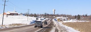
Whitewater Region is a township on the Ottawa River in Renfrew County, located within the scenic Ottawa Valley in eastern Ontario, Canada. Whitewater Region is made up of the former municipalities of Beachburg, Cobden, Ross and Westmeath, which were amalgamated into the current township on January 1, 2001.

The Senate of Canada Building is a government building and former railway station that serves as the temporary seat of the Senate of Canada. Located at 2 Rideau Street in downtown Ottawa, it was known as Ottawa Union Station and served as the city's central railway station from 1912 until 1966. From 1966 to 2018, it was operated by the Government of Canada as the Government Conference Centre. The building currently includes a temporary Senate chamber, as well as some Senate offices and committee rooms.

Barrhaven is a suburb of Ottawa, Ontario, Canada. It is located about 17 km (11 mi) southwest of the city's downtown core. Prior to amalgamation with Ottawa in 2001, Barrhaven was part of the City of Nepean. Its population as of the Canada 2021 Census was 103,234.
The Bytown and Prescott Railway (B&PR) was a railway joining Ottawa with Prescott on the Saint Lawrence River, in the Province of Canada. The company was incorporated in 1850, and the first train ran from Prescott into Bytown on Christmas Day, 1854. The 84 kilometres (52 mi) railway, Ottawa's first to outside markets, was initially used to ship lumber collected on the Ottawa River for further shipping along the St. Lawrence to markets in the United States and Montreal.

Ottawa station, or Ottawa Train Station, is the main inter-city train station in Ottawa, Ontario, Canada, the capital of Canada. It is operated by Via Rail. It is located 4 kilometres (2.5 mi) east of downtown Ottawa and adjacent to Tremblay O-Train station in the neighbourhood of Eastway Gardens. The station serves inter-city trains connecting to Toronto, Kingston, Montreal and Quebec City on Via Rail's Corridor Route.
The Chief William Commanda Bridge, formerly the Prince of Wales Bridge, is a pedestrian/cycling bridge and former rail bridge that spans the Ottawa River between Ottawa, Ontario and Gatineau, Quebec, Canada. It connects the Trillium Pathway in Ottawa to the Voyageurs Pathway in Gatineau. The bridge crosses the south channel of the river to Lemieux Island at the edge of Nepean Bay and continues across the northern channel into the Province of Quebec.

Bells Corners is a suburban neighbourhood in Ottawa, Ontario, Canada. It is located along Robertson Road west of downtown, within Ottawa's western Greenbelt, in College Ward. As of the Canada 2016 Census, the community had a population of 9,272.
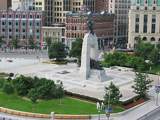
Confederation Square is an urban square in Ottawa, Ontario, Canada, and is considered the second most important ceremonial centre in Canada's capital city, after Parliament Hill. Roughly triangular in area, with Canada's National War Memorial at its centre and the Valiants Memorial at its periphery, the square is bounded by Wellington Street to the north and branches of Elgin Street to the east and west.
This is a timeline of the history of Ottawa.

The Capital Pathway, also known informally as the Bike Path, is a 220-kilometre (140 mi) recreational pathway interlinking many parks, waterways and sites in Ottawa, Ontario and Gatineau, Quebec. Most of the pathway is paved, and allows an almost continuous route through the National Capital Region.
The history of Ottawa, capital of Canada, was shaped by events such as the construction of the Rideau Canal, the lumber industry, the choice of Ottawa as the location of Canada's capital, as well as American and European influences and interactions. By 1914, Ottawa's population had surpassed 100,000 and today it is the capital of a G7 country whose metropolitan population exceeds one million.
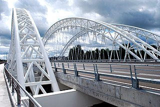
The Vimy Memorial Bridge is a bridge in Ottawa, Ontario, Canada. Completed in 2014, it crosses the Rideau River, connecting Strandherd Drive in Barrhaven and Earl Armstrong Road in Riverside South. The bridge was the 2015 winner of the Gustav Lindenthal Medal. It is named after the Battle of Vimy Ridge, as suggested by two Royal Canadian Legions in Ottawa.

The Canadian National Railway's Beachburg Subdivision or "Beachburg Sub" for short, was part of the former Transcontinental Mainline. The Beachburg Sub connected Ottawa to Brent, Ontario.

The O-Train is a light rail rapid transit system in Ottawa, Ontario, Canada, operated by OC Transpo. The O-Train system has two lines, the electrically-operated Confederation Line and the diesel-operated Trillium Line. Since May 2020, Stage 2 construction has temporarily shut down Line 2, with replacement bus service being offered at all stations. When Line 2 reopens in 2024, it will extend southward to Limebank station and incorporate five newly constructed stations, as well as an additional line linking Line 2 to Ottawa International Airport which will replace the current bus service from route 97. By 2026, expansions along Line 1 and the construction of Line 3 stations in the west end are expected to be complete, bringing the system's length to 64.5 km (40.1 mi), four lines and 41 stations. The O-Train network is fully grade separated and does not have any level crossings with roads.
Murray Albert Heit was a Canadian politician and dentist. He served as an alderman on Ottawa City Council from 1959 to 1964 and as a controller on the Ottawa Board of Control from 1965 to 1969.

