Related Research Articles

The Parts of Holland is a historical division of Lincolnshire, England, encompassing the southeast of the county. The name is still recognised locally and survives in the district of South Holland.
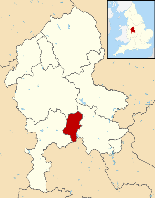
South Staffordshire is a local government district in Staffordshire, England. Its council is based in Codsall. Other notable settlements include Brewood, Cheslyn Hay, Coven, Essington, Featherstone, Four Ashes, Great Wyrley, Huntington, Kinver, Landywood, Penkridge, Perton, Wedges Mills, Weston-under-Lizard and Wombourne. The district covers a largely rural area lying immediately to the west and north-west of the West Midlands conurbation.
Cannock Chase is a local government district in Staffordshire, England. It is named after and covers a large part of Cannock Chase, a designated National Landscape. The council is based in the town of Cannock. The district also contains the towns of Hednesford and Rugeley, as well as a number of villages and surrounding rural areas.
Kettering was a rural district in Northamptonshire in England from 1894 to 1974.
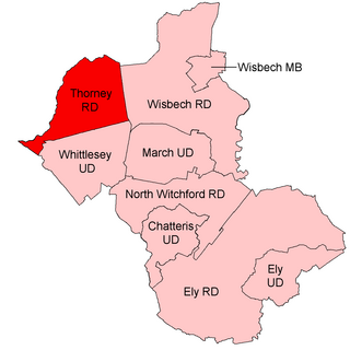
Thorney was a rural district in England from 1894 to 1974, situated to the east of Peterborough.
Spalding was a rural district in Holland in Lincolnshire, England from 1894 to 1974.
Bowland was a rural district in the West Riding of Yorkshire from 1894 to 1974. It was named after the Forest of Bowland, which it included.
Repton was a rural district in Derbyshire, England from 1894 to 1974.
Tamworth was a rural district in the English Midlands from 1894 to 1965.
Northampton was a rural district in Northamptonshire, England from 1894 to 1974.
Newark was a rural district in Nottinghamshire, England from 1894 to 1974.

Bingham was a rural district in Nottinghamshire, England from 1894 to 1974.
Gnosall was a rural district in Staffordshire, England from 1894 to 1934. It was formed under the Local Government Act 1894 from that part of the Newport Rural Sanitary District which was in Staffordshire.
Newport was a rural district in Shropshire, England from 1894 to 1934.
Wellington was a rural district in Shropshire, England from 1894 to 1974.
The Daventry Rural District was a rural district in Northamptonshire, England from 1894 to 1974. It entirely surrounded the municipal borough of Daventry. The district was administered from Daventry but did not include the town.
Drayton or Market Drayton was a rural district in Shropshire, England from 1894 to 1974. It was created by the Local Government Act 1894 under the name 'Drayton', from that part of the Market Drayton rural sanitary district which was in Shropshire.
Blore Heath was a rural district in Staffordshire, England from 1894 to 1932.
Shifnal was a rural district in Shropshire, England from 1894 to 1974.
Seisdon was a rural district in Staffordshire, England from 1894 to 1974. It lay to the west of Wolverhampton and was formed under the Local Government Act 1894 based on the Seisdon rural sanitary district.