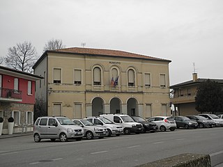
Caorso

Last updated
Caorso
Comune
Comune di Caorso
Italy provincial location map 2015.svg
Red pog.svg
Caorso
Location of Caorso in Italy
Coordinates: 45°3′N9°52′E / 45.050°N 9.867°E / 45.050; 9.867 Coordinates: 45°3′N9°52′E / 45.050°N 9.867°E / 45.050; 9.867
Country Italy
Region Emilia-Romagna
Province Piacenza (PC)
Frazioni Muradolo, Zerbio, Roncarolo, Fossadello
Government
  Mayor Roberta Battaglia
Area
  Total 40.9 km2 (15.8 sq mi)
Elevation 46 m (151 ft)
Population (30 April 2017) [1]
  Total 4,718
  Density 120/km2 (300/sq mi)
Demonym(s) Caorsani
Time zone CET (UTC+1)
  Summer (DST) CEST (UTC+2)
Postal code29012
Dialing code 0523
Website Official website
the old nuclear power plant Centrale nucleare di Caorso.jpg
the old nuclear power plant

Caorso (Piacentino: Caurs) is a comune (municipality) in the Province of Piacenza in the Italian region Emilia-Romagna, located about 130 kilometres (81 mi) northwest of Bologna and about 13 kilometres (8 mi) east of Piacenza.

<i>Comune</i> third-level administrative divisions of the Italian Republic

The comune is a basic administrative division in Italy, roughly equivalent to a township or municipality.

Province of Piacenza Province of Italy

The province of Piacenza is a province in the Emilia-Romagna region of Italy. Its provincial capital is the city Piacenza. As of 2016, it has a total population of 286,572 inhabitants over an area of 2,585.86 square kilometres (998.41 sq mi), giving it a population density of 111.38 inhabitants per square kilometre. The city Piacenza has a population of 102,269, as of 2015. The provincial president is Patrizia Barbieri and it contains 48 comuni. The province dates back to its founding by the Romans in 218 BCE.

Italy republic in Southern Europe

Italy, officially the Italian Republic, is a country in Southern and Western Europe. Located in the middle of the Mediterranean Sea, Italy shares open land borders with France, Switzerland, Austria, Slovenia and the enclaved microstates San Marino and Vatican City. Italy covers an area of 301,340 km2 (116,350 sq mi) and has a largely temperate seasonal and Mediterranean climate. With around 61 million inhabitants, it is the fourth-most populous EU member state and the most populous country in Southern Europe.

Contents

Caorso borders the following municipalities: Caselle Landi, Castelnuovo Bocca d'Adda, Cortemaggiore, Monticelli d'Ongina, Piacenza, Pontenure, San Pietro in Cerro.

Caselle Landi Comune in Lombardy, Italy

Caselle Landi is a comune (municipality) in the Province of Lodi in the Italian region Lombardy, located about 70 kilometres (43 mi) southeast of Milan and about 35 kilometres (22 mi) southeast of Lodi.

Castelnuovo Bocca dAdda Comune in Lombardy, Italy

Castelnuovo Bocca d'Adda is a comune (municipality) in the Province of Lodi in the Italian region Lombardy, located about 70 kilometres (43 mi) southeast of Milan and about 35 kilometres (22 mi) southeast of Lodi.

Cortemaggiore Comune in Emilia-Romagna, Italy

Cortemaggiore is an Italian comune located in the Province of Piacenza.

Transportation

Caorso has a railway station on the Piacenza–Cremona line.

Piacenza–Cremona railway

The Piacenza–Cremona railway is a railway line in Italy.

Related Research Articles

Megliadino San Vitale Comune in Veneto, Italy

Megliadino San Vitale is a comune (municipality) in the Province of Padua in the Italian region Veneto, located about 70 kilometres (43 mi) southwest of Venice and about 35 kilometres (22 mi) southwest of Padua.

Piacenza dAdige Comune in Veneto, Italy

Piacenza d'Adige is a comune (municipality) in the Province of Padua in the Italian region Veneto, located about 70 kilometres (43 mi) southwest of Venice and about 40 kilometres (25 mi) southwest of Padua. As of 31 December 2004, it had a population of 1,371 and an area of 18.6 square kilometres (7.2 sq mi).

Ponso Comune in Veneto, Italy

Ponso is a comune (municipality) in the Province of Padua in the Italian region Veneto, located about 60 kilometres (37 mi) southwest of Venice and about 35 kilometres (22 mi) southwest of Padua. As of 31 December 2004, it had a population of 2,435 and an area of 10.9 square kilometres (4.2 sq mi).

SantUrbano Comune in Veneto, Italy

Sant'Urbano is a comune (municipality) in the Province of Padua in the Italian region Veneto, located about 60 kilometres (37 mi) southwest of Venice and about 35 kilometres (22 mi) southwest of Padua. As of 31 December 2004, it had a population of 2,189 and an area of 31.8 square kilometres (12.3 sq mi).

Vighizzolo dEste Comune in Veneto, Italy

Vighizzolo d'Este is a comune (municipality) in the Province of Padua in the Italian region Veneto, located about 60 kilometres (37 mi) southwest of Venice and about 30 kilometres (19 mi) southwest of Padua.

Alseno Comune in Emilia-Romagna, Italy

Alseno is a comune (municipality) in the Province of Piacenza in the Italian region Emilia-Romagna, located about 120 kilometres (75 mi) northwest of Bologna and about 25 kilometres (16 mi) southeast of Piacenza.

Besenzone Comune in Emilia-Romagna, Italy

Besenzone is a comune (municipality) in the Province of Piacenza in the Italian region Emilia-Romagna, located about 120 kilometres (75 mi) northwest of Bologna and about 20 kilometres (12 mi) southeast of Piacenza.

Carpaneto Piacentino Comune in Emilia-Romagna, Italy

Carpaneto Piacentino is a comune (municipality) in the Province of Piacenza in the Italian region of Emilia-Romagna, located about 130 kilometres (81 mi) northwest of Bologna and about 15 kilometres (9 mi) southeast of Piacenza.

Castelvetro Piacentino Comune in Emilia-Romagna, Italy

Castelvetro Piacentino, also known as Castelvetro, is a town and comune (municipality) in the Province of Piacenza in the Italian region Emilia-Romagna, located about 130 kilometres (81 mi) northwest of Bologna and about 25 kilometres (16 mi) east of Piacenza.

Ferriere Comune in Emilia-Romagna, Italy

Ferriere is a comune (municipality) in the Province of Piacenza in the Italian region Emilia-Romagna, located about 150 kilometres (93 mi) west of Bologna and about 45 kilometres (28 mi) southwest of Piacenza, in the Val Nure of the Ligurian Appennines.

Gropparello Comune in Emilia-Romagna, Italy

Gropparello is a comune (municipality) in the Province of Piacenza in the Italian region Emilia-Romagna, located about 130 kilometres (81 mi) northwest of Bologna and about 25 kilometres (16 mi) south of Piacenza.

Lugagnano Val dArda Comune in Emilia-Romagna, Italy

Lugagnano Val d'Arda is a comune (municipality) in the Province of Piacenza in the Italian region Emilia-Romagna, located about 130 kilometres (81 mi) northwest of Bologna and about 30 kilometres (19 mi) southeast of Piacenza, on the Arda stream.

Monticelli dOngina Comune in Emilia-Romagna, Italy

Monticelli d'Ongina is a comune (municipality) in the Province of Piacenza in the Italian region Emilia-Romagna, located about 130 kilometres (81 mi) northwest of Bologna and about 20 kilometres (12 mi) east of Piacenza.

Piozzano Comune in Emilia-Romagna, Italy

Piozzano is a comune (municipality) in the Province of Piacenza in the Italian region Emilia-Romagna, located about 150 kilometres (93 mi) northwest of Bologna and about 20 kilometres (12 mi) southwest of Piacenza.

Pontenure Comune in Emilia-Romagna, Italy

Pontenure is a comune (municipality) in the Province of Piacenza in the Italian region Emilia-Romagna, located about 140 kilometres (87 mi) northwest of Bologna and about 9 kilometres (6 mi) southeast of Piacenza.

San Pietro in Cerro Comune in Emilia-Romagna, Italy

San Pietro in Cerro is a comune (municipality) in the Province of Piacenza in the Italian region Emilia-Romagna, located about 120 kilometres (75 mi) northwest of Bologna and about 20 kilometres (12 mi) east of Piacenza. As of 31 December 2004, it had a population of 962 and an area of 27.5 square kilometres (10.6 sq mi).

Vernasca Comune in Emilia-Romagna, Italy

Vernasca is a comune (municipality) in the Province of Piacenza in the Italian region Emilia-Romagna, located about 120 kilometres (75 mi) northwest of Bologna and about 30 kilometres (19 mi) southeast of Piacenza.

Santo Stefano Lodigiano Comune in Lombardy, Italy

Santo Stefano Lodigiano is a comune (municipality) in the Province of Lodi in the Italian region Lombardy, located about 60 kilometres (37 mi) southeast of Milan and about 25 kilometres (16 mi) southeast of Lodi.

References

  1. All demographics and other statistics: Italian statistical institute Istat.