Geography and climate
Caparangasan is situated in the central western and also coastal part of the island of Samar within the Philippine Sea and archipelago. It is bordered by Lungib to the south, Napalisan to the west, Sondara Island to the north, and Malayog to the east.
It has a total area of approximately 3.5 square kilometres (350 ha) of flat coastal plain terrain with an elevation ranging from 0 to 4 metres (0 to 13 ft) above the sea level. It experiences a variety of wind types: the Amihan, from northeast, the Timog, from south, the Habagat, from southwest, the Canaway, from northwest, the Cabunghan from east, the Dumagsa, from southeast, and the Salatan from the west. It has distributed rainfall throughout the year, except during the summer months, from February through May, when it is dry.

Leyte is an island in the Visayas group of islands in the Philippines. It is eighth-largest and sixth-most populous island in the Philippines, with a total population of 2,626,970 as of 2020 census.

Leyte Gulf is a gulf in the Eastern Visayan region in the Philippines. The bay is part of the Philippine Sea of the Pacific Ocean, and is bounded by two islands; Samar in the north and Leyte in the west. On the south of the bay is Mindanao Island, separated from Leyte by the Surigao Strait. Dinagat Island partly encloses the gulf to the southeast, and the small Homonhon Island and Suluan Island, sit astride the eastern entrance to the Gulf. It is approximately 130 km (81 mi) north-south, and 60 km (37 mi) east-west.

Leyte is a province in the Philippines located in the Eastern Visayas region, occupying the northern three-quarters of Leyte Island. Its capital is the city of Tacloban, administered independently from the province. Leyte is situated west of Samar Island, north of Southern Leyte and south of Biliran. To the west across the Camotes Sea is the province of Cebu.

The Philippine Sea is a marginal sea of the Western Pacific Ocean east of the Philippine archipelago, the largest in the world, occupying an estimated surface area of 5 million square kilometers. The Philippine Sea Plate forms the floor of the sea. Its western border is the first island chain to the west, comprising the Ryukyu Islands in the northwest and Taiwan in the west. Its southwestern border comprises the Philippine islands of Luzon, Catanduanes, Samar, Leyte, and Mindanao. Its northern border comprises the Japanese islands of Honshu, Shikoku and Kyūshū. Its eastern border is the second island chain to the east, comprising the Bonin Islands and Iwo Jima in the northeast, the Mariana Islands in the due east, and Halmahera, Palau, Yap and Ulithi in the southeast. Its southern border is Indonesia's Morotai Island.
Northern Samar is a province in the Philippines located in the Eastern Visayas region. Its capital is Catarman and is located at the northern portion of the island of Samar. Bordering the province to the south are the provinces of Samar and Eastern Samar. To the northwest, across the San Bernardino Strait is Sorsogon; to the east is the Philippine Sea and to the west is Samar Sea.
Eastern Samar is a province in the Philippines located in the Eastern Visayas region. Its capital is the city of Borongan. Eastern Samar occupies the eastern portion of the island of Samar. Bordering the province to the north is the province of Northern Samar and to the west is Samar province. To the east lies the Philippine Sea, part of the vast Pacific Ocean, while to the south lies the Leyte Gulf.

The Visayan Sea is a sea in the Philippines surrounded by the islands of the Visayas. It is bounded by the islands Masbate to the north, Panay to the west, Leyte to the east, and Cebu and Negros to the south.

Samar is the third-largest and seventh-most populous island in the Philippines. With a total population of 1,909,537 as of 2020 census. It is located in the eastern Visayas, which are in the central Philippines. The island is divided into three provinces: Samar, Northern Samar, and Eastern Samar. These three provinces, along with the provinces on the nearby islands of Leyte and Biliran, are part of the Eastern Visayas region.

Calbayog, officially known as the City of Calbayog, is a 1st class component city in the province of Samar, Philippines. According to the 2020 census, it has a population of 186,960 people.

Lavezares, officially the Municipality of Lavezares, is a 4th class municipality in the province of Northern Samar, Philippines. According to the 2020 census, it has a population of 29,390 people.

Palapag, officially the Municipality of Palapag, is a 3rd class municipality in the province of Northern Samar, Philippines. According to the 2020 census, it has a population of 34,034 people.

San Jose, officially the Municipality of San Jose, is a 5th class municipality in the province of Northern Samar, Philippines. According to the 2020 census, it has a population of 17,641 people.

Guiuan, officially the Municipality of Guiuan, is a 2nd class municipality in the province of Eastern Samar, Philippines. It constitutes the southeastern extremity of Samar Island and some adjacent islands, surrounded by major bodies of water including the Leyte Gulf and the Philippine Sea. According to the 2020 census, it has a population of 53,361 people, making it the most populous municipality in Eastern Samar and the second most populous administrative division in the entire province after the capital city Borongan.
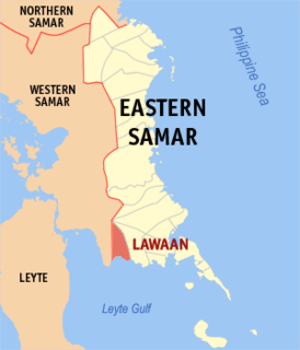
Lawaan, officially the Municipality of Lawaan, is a 5th class municipality in the province of Eastern Samar, Philippines. According to the 2020 census, it has a population of 13,003 people. It is home to Bolusao Watershed Forest Reserve, primarily located in Barangay Bolusao.

The Samar Sea is a small sea within the Philippine archipelago, situated between the Bicol Region of Luzon and the Eastern Visayas.

San Pedro Bay is a bay in the Philippines, at the northwest end of Leyte Gulf, about 15 km east–west and 20 km north–south. The bay is bounded by two islands; on the north and east by Samar, and on the east by Leyte. It is connected by San Juanico Strait to Carigara Bay of the Samar Sea. The largest city on the bay is Tacloban City, the capital of Leyte province.
The 1939 Pacific typhoon season has no official bounds; it ran year-round in 1939, but most tropical cyclones tend to form in the northwestern Pacific Ocean between May and November. These dates conventionally delimit the period of each year when most tropical cyclones form in the northwestern Pacific Ocean.
The Roman Catholic Diocese of Borongan is a Roman Rite diocese of the Latin Church of the Catholic Church in the Philippines.

Eastern Visayas is an administrative region in the Philippines, designated as Region VIII. It consists of three main islands, Samar, Leyte and Biliran. The region has six provinces, one independent city and one highly urbanized city namely, Biliran, Leyte, Northern Samar, Samar, Eastern Samar, Southern Leyte, Ormoc and Tacloban. The highly urbanized city of Tacloban is the sole regional center. These provinces and cities occupy the easternmost islands of the Visayas group of islands.
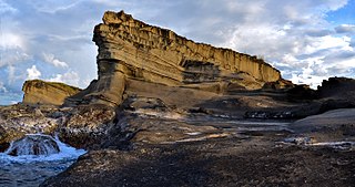
The Biri Larosa Protected Landscape and Seascape is a protected area located in Northern Samar, Philippines, about 40 kilometres (25 mi) west of Catarman. It protects the Balicuatro Islands, composed of the island municipality of Biri and associated smaller islands, off the northwestern coast of Samar in the San Bernardino Strait. It also includes the coastal areas of the adjacent municipalities from which it derives the second half of its name – a combination of the first two letters of Lavezares, Rosario and San Jose.
