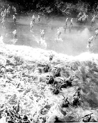
The Battle of Cape Gloucester was fought in the Pacific theater of World War II between Japanese and Allied forces on the island of New Britain, Territory of New Guinea, between 26 December 1943 and 16 January 1944. Codenamed Operation Backhander, the US landing formed part of the wider Operation Cartwheel, the main Allied strategy in the South West Pacific Area and Pacific Ocean Areas during 1943–1944. It was the second landing the US 1st Marine Division had conducted during the war thus far, after Guadalcanal. The objective of the operation was to capture the two Japanese airfields near Cape Gloucester that were defended by elements of the Japanese 17th Division.
Royal Air Force Steeple Morden or more simply RAF Steeple Morden is a former Royal Air Force station located 3.5 miles (5.6 km) west of Royston, Hertfordshire, England.

Gurney Airport is an airport serving Alotau in the Milne Bay Province of Papua New Guinea (PNG).
Buka Airport is an airport serving Buka Island in the Autonomous Region of Bougainville in Papua New Guinea.
Munda Airport is an international airport adjacent to the town of Munda, Western Province in Solomon Islands.

Statesboro–Bulloch County Airport is a public airport located three miles (5 km) northeast of the central business district of Statesboro, a city in Bulloch County, Georgia, United States. It is owned by the City of Statesboro and Bulloch County. Currently, there is no commercial service to the airport.

Fenton Airfield was a World War II military airfield in the Northern Territory of Australia located at Tipperary Station in what is now the locality of Douglas-Daly and named after flight lieutenant Clyde Fenton.
Finschhafen Airport is a general aviation airport in Morobe Province, Papua New Guinea.. It is located on the south-east tip of Huon Peninsula at Finschafen. A half mile inland, parallel to Schneider Harbor, with Dregerhaffen to the south-east. It has no scheduled commercial airline service.
Gusap Airport is a general aviation airport in Morobe Province, Papua New Guinea. located at the base of the Finisterre Range. It has no scheduled commercial airline service. It is currently in use, and maintained by Ramu Agri Industries Ltd. (RAIL) for Crop Dusting purposes.

Scarlett Martínez International Airport, also known as Río Hato Airport, is an international airport serving Río Hato, a town in the Coclé Province of Panama. The airport is 3 kilometres (2 mi) east of Río Hato.

Thomasville Regional Airport is a city-owned, public-use airport located six nautical miles northeast of the central business district of Thomasville, a city in Thomas County, Georgia, United States. It is included in the National Plan of Integrated Airport Systems for 2011–2015, which categorized it as a general aviation facility. The airport does not have scheduled commercial airline service.

Dinjan Airfield, also known as Dinjan Air Force Station, is an air base of Indian Air Force. Established as an air field in World War II, it is located in Dinjan, approximately seven miles northeast of Chabua, in the state of Assam, India.
Berteaux Airfield is an abandoned World War II United States Army Air Forces military airfield in Algeria, which was located approximately 9 km east of Telerghma; 35 km southwest of Constantine.

Gioia del Colle Air Base is an Italian Air Force base located in the province of Bari, Apulia, Italy, located approximately 1 km south-southeast of Gioia del Colle.

Decimomannu Air Base is an Italian Air Force air base located approximately 5 km (2.7 NM) north of Decimomannu a comune in the Province of Cagliari on the island of Sardinia in Italy.
Haguenau Airport is an airport in France, located about 2 miles southeast of Haguenau ; 15 miles north of Strasburg and 250 miles east of Paris.

Mainz-Finthen Airport(German: Flugplatz Mainz-Finthen) is an airport in Germany, located about 3 miles (5 km) southwest of Mainz and approximately 320 miles (510 km) southwest of Berlin.
Alexai Point Army Airfield is an abandoned World War II airfield with two runways laid across Alexai Point on Attu Island, Alaska. The remains of the Seabee built airbase are located about 4 miles east of the closed Casco Cove Coast Guard Station, directly across Massacre Bay.

Pounds Army Air Field is a former United States Army Air Forces airfield, located 6 mi (9.7 km) west of Tyler, Texas. It was established in 1942 and assigned to Third Air Force. Its mission was the training of units, crews, and support individuals prior to their deployment to the combat theaters overseas. It was closed as an active military airfield on 31 January 1945 and was subsequently turned over to local civilian authorities. Today it remains in use by the city of Tyler as Tyler Pounds Regional Airport.
Naval Air Facility Adak, was a United States Navy airport located west of Adak, on Adak Island in the U.S. state of Alaska. After its closure in 1997, it was reopened as Adak Airport. The facility was designated a National Historic Landmark for its role in World War II, although most of its elements from that period have been demolished or lie in ruins.

