Carcajou is an alternative common name for the wolverine, Gulo gulo. It may also refer to:
Jackman Flats Provincial Park is a provincial park in British Columbia, Canada, comprising approximately 615 ha. and located just southeast of Tête Jaune Cache in the Rocky Mountain Trench, near the Yellowhead Pass. The park features several hiking trails.

The Smoky River is a river in western Alberta, Canada. It is a major tributary of the Peace River. The descriptive name refers to the presence of "smouldering beds of coal in the riverbank" noted by the Cree Indians.
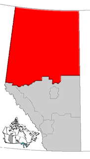
Northern Alberta is a region located in the Canadian province of Alberta.
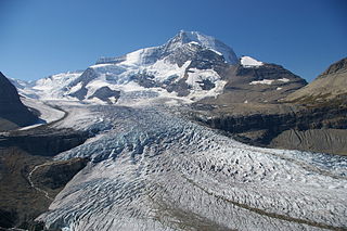
The Robson Glacier is the primary source of the short Robson River, one of the uppermost tributaries of the Fraser River. Located on the British Columbia-Alberta Boundary and the Continental Divide to the east of Berg Lake in Mount Robson Provincial Park, it sits on the northeast flank of Mount Robson in Mount Robson Provincial Park, British Columbia in the Canadian Rockies. Its meltwater feeds unofficially named Robson Lake, whose outlet marks the start of the Robson River.

Strathcona County Transit provides local, commuter and school bus services to the community of Sherwood Park, Alberta, Canada, which is situated just east of Edmonton in Strathcona County. Transportation for elderly citizens and people with disabilities is provided by Strathcona County Accessible Transportation (SCAT) within Sherwood Park and rural Strathcona County.

Kimball is a hamlet in southern Alberta, Canada within Cardston County. It is located on Highway 501, approximately 16 kilometres (9.9 mi) southeast of Cardston between the St. Mary River and the Milk River Ridge. The community is named after the Mormon ward which was named after the descendents of Heber C Kimball.
Simpson Pass, el. 2,107 m (6,913 ft), is a mountain pass on the border between the Canadian provinces of Alberta and British Columbia, in the area of the Ball Range. It is the prominence col for Mount Ball on the Continental Divide in the vicinity of Sunshine Village ski resort. Simpson River and Simpson Pass are named after Sir George Simpson who first explored the area in 1841.

Kujanki is a village in the administrative district of Gmina Człuchów, within Człuchów County, Pomeranian Voivodeship, in northern Poland. It lies approximately 11 kilometres (7 mi) north-west of Człuchów and 119 km (74 mi) south-west of the regional capital Gdańsk.
Blueberry Mountain is an unincorporated community in northwestern Alberta in Saddle Hills County, located on Highway 725, 91 kilometres (57 mi) north of Grande Prairie.
Jarvis Pass is a mountain pass in Kakwa Provincial Park in the Northern Rockies of British Columbia, Canada, located to the north of Kakwa Lake, on the British Columbia-Alberta boundary, and therefore is on the Continental Divide. It was one of the many passes surveyed as a route for the Canadian Pacific Railway in the 1870s.
Demmitt is a hamlet in northern Alberta, Canada within the County of Grande Prairie No. 1. It is located on Highway 43, approximately 77 kilometres (48 mi) northwest of Grande Prairie. The Northern Alberta Railway was built through the area in 1930 as it extended westwards towards Dawson Creek, British Columbia.
Palliser Pass, 2084 m (6837 ft), is a mountain pass in the Canadian Rockies, located on the British Columbia / Alberta boundary at the south end of Banff National Park and at the north end of Height of the Rockies Provincial Park in British Columbia. The pass is located north of the headwaters of the Palliser River.
Tonquin Pass, 1948 m (6393 ft), is a mountain pass in the Canadian Rockies, linking Tonquin Valley in Jasper National Park, Alberta, to Mount Robson Provincial Park and adjoining areas of British Columbia. It is at the headwaters of Tonquin Creek, which flows into British Columbia. Located on the interprovincial boundary, it is on the Continental Divide.

Jasper House National Historic Site, in Jasper National Park, Alberta, is the site of a trading post on the Athabasca River that functioned in two different locations from 1813 to 1884 as a major staging and supply post for travel through the Canadian Rockies.

The Alberta Mountain forests are a temperate coniferous forests ecoregion of Canada.
Earls is an unincorporated community located in Amelia County, in the U.S. state of Virginia.

The Alberta Coal Branch is the name given to a segment of the Canadian National Railway and the region through which it passes. It is located within Yellowhead County in west-central Alberta, Canada.
Casket Mountain is a summit in Alberta, Canada.


