
Ishpatina Ridge is the highest point of land in the Canadian province of Ontario, at an estimated 693 m (2,274 ft) above sea level. Ishpatina Ridge rises approximately 300 m (984 ft) above the immediate area. It was only truly recognized as Ontario's highest point after topographical mapping by the Government of Canada revealed this fact in the 1970s. Before then, the more popular Maple Mountain was thought to be higher.

Temagami, formerly spelled as Timagami, is a municipality in northeastern Ontario, Canada, in the Nipissing District with Lake Temagami at its heart.

Caribou Mountain is a large hill in Northeastern Ontario, Canada, located 1.5 km (0.93 mi) east of the village of Temagami. It contains a 30 m (98 ft) high fire tower that visitors can climb for a small fee. Its steep cliff overlooks the village of Temagami and is the closest lookout point to the village. Caribou Mountain, as well as the surrounding area, is situated in the Municipality of Temagami.
The White Bear Forest is an old growth forest, located in Temagami, Ontario, Canada. The forest is named after Chief White Bear, who was the last chief of the Teme-Augama Anishnabai before Europeans appeared in the region. In some parts of the White Bear Forest trees commonly reach 200 to 300 years in age, while the oldest tree accurately aged in White Bear Forest was a red pine that was 400 years old in 1999. The White Bear Forest contains one of Canada's oldest portages, dating back some 3,000 years. Today, more than 17 km (11 mi) of trails access the White Bear Forest. A trail guide is available online at http://ancientforest.org/whitebear.html.
Cross Lake is a lake in Temagami, Nipissing District, Ontario, Canada, about 20 kilometres (12 mi) southwest of the centre of that community. The lake has fish inhabits of walleye, smallmouth bass and northern pike.
Rib Lake is a long and narrow lake in the Town of Latchford and in the Municipality of Temagami in Northeastern Ontario, Canada, located about 9 kilometres (6 mi) southeast of the centre of the community of Latchford and 9 kilometres (6 mi) northeast of the community of Temagami North. The lake is in the Ottawa River drainage basin and is the main access for canoeists en route to Rib Mountain.
Snake Island Lake is a lake in the Ottawa River drainage basin in Strathy Township, Municipality of Temagami, Nipissing District of Northeastern Ontario, Canada.
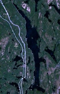
The Summit Lakes are a pair of lakes connected by a short creek in Nipissing District, Ontario, Canada, about 5 kilometres (3.1 mi) southeast of the community of Temagami. The Ontario Northland Railway mainline crosses the southern tip of the south lake on a trestle.
Fourbass Lake is a lake in Timiskaming District, Ontario, Canada, about 20 kilometres (12 mi) east of Temagami.
Gorrie Lake is a lake in Timiskaming District, Ontario, Canada, about 23 kilometres (14 mi) east of Temagami.
Link Lake is a narrow lake in Ottawa River drainage basin in Strathy Township, Temagami, Nipissing District of Northeastern Ontario, Canada. The abandoned Milne Townsite lies on the northern shore of the lake.
Arsenic Lake is a lake in the Ottawa River drainage basin in Strathy Township of Temagami, Nipissing District in Northeastern Ontario, Canada, located between the town of Temagami and Temagami North near Highway 11. It is the only officially named Arsenic Lake in Canada.

Chambers Township is a square-shaped geographic township comprising a portion of the municipality of Temagami in Nipissing District, Northeastern Ontario, Canada. It is used for geographic purposes, such as land surveying and natural resource explorations. Neighbouring geographic townships include Strathy Township, Briggs Township, Strathcona Township, Best Township and Banting Township.
Strathcona Township is a geographic township comprising a portion of the municipality of Temagami in Northeastern Ontario, Canada. It is used for geographic purposes, such as land surveying and natural resource explorations. A portion of the northeast arm of Lake Temagami lies at its northwestern corner. Neighbouring geographic townships include Strathy Township, Chambers Township, Briggs Township, Riddle Township and Cassels Township.
Briggs Township is a geographic township comprising a portion of the municipality of Temagami in Northeastern Ontario, Canada. It is used for geographic purposes, such as land surveying and natural resource explorations. Neighbouring geographic townships include Chambers Township, Joan Township and Strathcona Township.
Best Township is a geographic township comprising a portion of the municipality of Temagami in Nipissing District, Northeastern Ontario, Canada. It is used for geographic purposes, such as land surveying and natural resource explorations. Neighbouring geographic townships include Gillies Limited Township to the north, Banting Township to the west, Chambers Township to the southwest, and Strathy and Cassels townships to the south.
Joan Township is a geographic township in Temagami, Nipissing District, Northeastern Ontario, Canada, situated in the core of Lake Temagami. It covers much of Bear Island, the northern tip of Temagami Island, the Northwest Arm of Lake Temagami, Sand Point, and the Joan Peninsula.

Johnny Creek is one of many creeks running through the Temagami region of Northeastern Ontario, Canada. It is located about 4 km (2.5 mi) south of Temagami North in southeastern Strathy Township. The creek is entirely within the municipality of Temagami, flowing in a west–east direction.
The Three Sisters are a trio of lakes connected by short creeks in Nipissing District, Ontario, Canada, about 15 km (9.3 mi) north of the village of Temagami. They are arranged in a north–south trending line with a maximum length of about 2.5 km (1.6 mi). This group of lakes is situated in the geographic Best Township, which makes up part of the Municipality of Temagami.
Mount Ferguson, sometimes called Ferguson Mountain, is a mountain in the Municipality of Temagami, Northeastern Ontario, Canada. It overlooks Ferguson Bay of Lake Temagami with an elevation of 415 m (1,362 ft) above sea level, making it one of the highest mountains in the area. Mount Ferguson is situated near the boundary of geographic townships Cynthia and Aston.

