Carlisle city walls

Last updated

Tile Tower Tile Tower, Carlisle.JPG
Tile Tower
Tile Tower (from outside walls) Tile Tower from outside Carlisle City Walls 2.JPG
Tile Tower (from outside walls)

Carlisle city walls were a defensive structure surrounding the centre of Carlisle, Cumbria. The city walls ran from Carlisle Castle in the north-west of the city to The Citadel in the south-east. Between these points, the city was protected by the former North and East Walls (demolished around 1811) and the West Walls which remain largely intact. The line of the walls can still be followed with the exception of the southernmost end of the West Wall which has been built over. The perimeter, including the castle, is approximately 2.2 kilometres (1.4 mi) which is comparable to Southampton town walls but less than Chester city walls.

Carlisle Castle Castle in Cumbria, England

Carlisle Castle is situated in Carlisle, in the English county of Cumbria, near the ruins of Hadrian's Wall. The castle is over 900 years old and has been the scene of many historical episodes in British history. Given the proximity of Carlisle to the border between England and Scotland, it has been the centre of many wars and invasions. Today the castle is managed by English Heritage and is open to the public. The castle until recently was the administrative headquarters of the former King's Own Royal Border Regiment now county headquarters to the Duke of Lancaster's Regiment and a museum to the regiment is within the castle walls.

Carlisle Citadel Grade I listed building in the United Kingdom

Carlisle Citadel or The Citadel is a former medieval fortress on English Street in Carlisle, Cumbria. It comprises two towers, both of which are Grade I listed buildings: the Nisi Prius Courthouse and the former Crown Court.

Southampton town walls defensive walls in Southampton, United Kingdom

Southampton's town walls are a sequence of defensive structures built around the town in southern England. Although earlier Roman and Anglo-Saxon settlements around Southampton had been fortified with walls or ditches, the later walls originate with the move of the town to the current site in the 10th century. This new town was defended by banks, ditches and the natural curve of the river and coastline. The Normans built a castle in Southampton but made no attempts to improve the wider defences of the town until the early 13th century, when Southampton's growing prosperity as a trading centre and conflict with France encouraged the construction of a number of gatehouses and stone walls to the north and east sides of the settlement.

Contents

Construction

The Citadel from outside Carlisle railway station The Citadal, Carlisle - geograph.org.uk - 958858.jpg
The Citadel from outside Carlisle railway station

The Roman city of Carlisle was walled but the mediaeval walls were built to replace timber structures in the latter half of the twelfth-century. [1] The North Walls ran roughly east-southeastwards from the castle to Scotchgate and then on to Philipson's Tower. Here it turned roughly south to The Citadel. [1] The Citadel was built as a gate by Stefan von Haschenperg in the 1540s to replace an earlier structure. [2] It was later blocked and access to the city from the south was diverted around it through a new gate, Englishgate, built between The Citadel and Collier's Gate.

Luguvalium was a Roman town in northern Britain in antiquity. It was located within present-day Carlisle, Cumbria, and may have been the capital of the 4th-century province of Valentia.

Stefan von Haschenperg German military engineer

Stefan von Haschenperg was a military engineer employed by Henry VIII of England in the 1540s.

Demolition

Surviving fragment of north wall Half hexagon sentry post, from inside Carlisle city walls.JPG
Surviving fragment of north wall

The walls fell into disrepair at various times. A 1684 survey reported that The Citadel had been almost destroyed by the Scots. [3] By the end of the eighteenth-century, the need for easier access for traffic and the need for better ventilation of the crowded city led to demands for the walls' demolition and an Act of Parliament was passed in 1807. [4] The stone was used to redevelop The Citadel as a court building and in the construction of a new Eden Bridge to the north of the city. Both these projects involved Thomas Telford and Robert Smirke. [5] [6]

The Courts of England and Wales, supported administratively by Her Majesty's Courts and Tribunals Service, are the civil and criminal courts responsible for the administration of justice in England and Wales.

Thomas Telford Scottish civil engineer, architect and stonemason

Thomas Telford FRS, FRSE was a Scottish civil engineer, architect and stonemason, and road, bridge and canal builder. After establishing himself as an engineer of road and canal projects in Shropshire, he designed numerous infrastructure projects in his native Scotland, as well as harbours and tunnels. Such was his reputation as a prolific designer of highways and related bridges, he was dubbed The Colossus of Roads, and, reflecting his command of all types of civil engineering in the early 19th century, he was elected as the first President of the Institution of Civil Engineers, a post he held for 14 years until his death.

Robert Smirke (architect) English architect

Sir Robert Smirke was an English architect, one of the leaders of Greek Revival architecture, though he also used other architectural styles. As architect to the Board of Works, he designed several major public buildings, including the main block and facade of the British Museum. He was a pioneer of the use of concrete foundations.

More recent changes

Site of The Fawcett School Site of The Fawcett School 1850.JPG
Site of The Fawcett School
Irish Gate footbridge Irish Gate footbridge - geograph.org.uk - 961961.jpg
Irish Gate footbridge

The West Walls are still needed to retain a former river cliff on the River Caldew and were not demolished. They have however been considerably altered over the years. Comparisons between old engravings and current archaeological evidence suggest the wall has been straightened. [7] Between the bridge and the castle, there were houses built up against the walls until 1952. [8] Other buildings erected against the walls have been largely removed so the walls are visible again. Remaining buildings have been listed because they incorporate wall fragments. [9]

River Caldew river in the United Kingdom

The River Caldew is a river running through Cumbria in England. Historically, the county watered by the Caldew was Cumberland.

Engraving practice of incising a design on to a hard, usually flat surface, by cutting grooves into it

Engraving is the practice of incising a design onto a hard, usually flat surface by cutting grooves into it with a burin. The result may be a decorated object in itself, as when silver, gold, steel, or glass are engraved, or may provide an intaglio printing plate, of copper or another metal, for printing images on paper as prints or illustrations; these images are also called "engravings". Engraving is one of the oldest and most important techniques in printmaking. Wood engraving is a form of relief printing and is not covered in this article.

Grade I listed buildings in Cumbria Wikimedia list article

There are over 9000 Grade I listed buildings in England. This page is a list of these buildings in the county of Cumbria, sub-divided by district.

Short lengths of the North and West Walls run south from the castle to a city centre bypass that separates the castle from the city centre. The construction of the bypass required the existing gap in the West Walls to be widened and the surviving fragment of the North Walls to be truncated further. The gap in the West Walls includes the site of Irishgate and this is commemorated by a modern footbridge. [10]

Related Research Articles

Cumberland Historic county of England

Cumberland is a historic county of North West England that had an administrative function from the 12th century until 1974. It was bordered by Northumberland to the east, County Durham to the southeast, Westmorland and Lancashire to the south, and the Scottish counties of Dumfriesshire and Roxburghshire to the north. It formed an administrative county from 1889 to 1974 and now forms part of Cumbria.

Carvetii British tribe of the Iron Age and Roman era

The Carvetii were an Iron Age people and were subsequently identified as a civitas (canton) of Roman Britain living in what is now Cumbria, in North-West England.

St Bees farm village in the United Kingdom

St Bees is a coastal village, civil parish and electoral ward in the Copeland district of Cumbria, England, on the Irish Sea. It was originally in the historic county of Cumberland.

Clifton, Cumbria village in Cumbria, England

Clifton is a small linear village and civil parish in Cumbria, England. Historically part of Westmorland, it lies 3 miles (4.8 km) south east of Penrith.

Beaumont, Cumbria village in the United Kingdom

Beaumont is a village and civil parish in the City of Carlisle district of Cumbria, England. The village lies four miles north-west of Carlisle on the banks of the River Eden.

Inglewood Forest

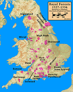
Inglewood Forest is a large tract of mainly arable and dairy farm land with a few small woodland areas between Carlisle and Penrith in the English non-metropolitan county of Cumbria or ancient county of Cumberland.

History of Cumbria

The history of Cumbria as a county of England begins with the Local Government Act 1972. Its territory and constituent parts however have a long history under various other administrative and historic units of governance. Cumbria is an upland, coastal and rural area, with a history of invasions, migration and settlement, as well as battles and skirmishes between the English and the Scots.

Brougham Castle Medieval castle near Penrith in Cumbria, England

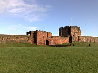
Brougham Castle is a medieval building about 2 miles (3.2 km) south-east of Penrith, Cumbria, England. The castle was founded by Robert I de Vieuxpont in the early 13th century. The site, near the confluence of the rivers, Eamont and Lowther, had been chosen by the Romans for a Roman fort called Brocavum. The castle is scheduled as an Ancient Monument, along with the fort, as "Brougham Roman fort and Brougham Castle".

Lacys Caves

Lacy's Caves are a series of 5 chambers in the red sandstone cliff of River Eden, just north of Little Salkeld, Cumbria, England, near Nunnery, at grid reference NY564383.

Ninekirks church in Eden, UK

Ninekirks is the local name for St Ninian's church, Brougham, Cumbria. Dedicated to Saint Ninian, it was formerly the Anglican parish church for Brougham, a parish which is now combined with Clifton, a neighbouring village. It is preserved as a redundant church for its architectural interest, and presents a mainly seventeenth-century appearance. It has been known as Ninekirks since at least 1583.

Portinscale village in United Kingdom

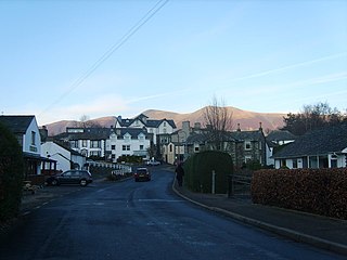
Portinscale is a village in Cumbria, England, close to the western shore of Derwentwater in the Lake District National Park 1.5 miles (2.4 km) from Keswick.

Dolfin was an 11th-century Anglo-Saxon magnate in Northumbria. His father was probably Gospatric, one of the most powerful regional figures in the mid-11th century having been earl of Northumbria in the early years of William the Conqueror's reign. Dolfin was the eldest of Gospatric's three sons, his younger brothers being Waltheof, lord of Allerdale, and Gospatric II, Earl of Lothian.

History of Medieval Cumbria

The history of medieval Cumbria has several points of interest. The region's status as a borderland coping with 400 years of warfare is one. The attitude of the English central government, at once uninterested and deeply interested, is another. As a border region, of geopolitical importance, Cumbria changed hands between the Angles, Norse, Strathclyde Brythons, Picts, Normans, Scots and English; and the emergence of the modern county is also worthy of study.

The Cumbria County History Trust (CCHT) was launched in May 2010 to coordinate and gather resources for the Victoria County History of Cumbria project, a collaborative community project created to research and write the histories of all parts of Cumbria, and to make historical information generally available, within the framework and standards of the Victoria County History of England.

Derventio was a Roman settlement at Papcastle on the river Derwent near Cockermouth, Cumbria, England. It was the site of a Roman fort, which was originally built in timber and rebuilt in stone. There was also a civilian settlement (vicus).

Ting Mound

The Ting Mound or Thing Moot at Fellfoot Farm, Little Langdale, Cumbria, England is an Ancient Monument. It is a natural mound which has been deliberately terraced, possibly in the tenth century, although it has not been dated archaeologically.

The Cumberland and Westmorland Antiquarian and Archaeological Society, founded in 1866, is a local historical, antiquarian, archaeological and text publication society and registered charity covering the modern county of Cumbria.

Roman Cumbria

Roman Cumbria was an area that lay on the north-west frontier of Roman Britain, and, indeed, of the Roman Empire itself.. Interest in the Roman occupation of the region lies in this frontier aspect - why did the Romans choose to occupy the north-west of England; why build a solid barrier in the north of the region ; why was the region so heavily militarised; to what extent were the native inhabitants 'Romanised' compared to their compatriots in southern England?

Greenholme hamlet in Eden, Cumbria, England

Greenholme is a hamlet in Cumbria, England.

References

  1. 1 2 McCarthy, M. R.; Summerson, H.R.T.; Annis, R.G. (1990). Carlisle Castle: A Survey and Documentary History (English Heritage Archaeological Report) (PDF). English Heritage.
  2. McCarthy, M. R. (1980). "Excavations on the city defences, Carlisle". Transactions of the Cumberland & Westmorland Antiquarian & Archaeological Society: 69–78.
  3. Ferguson, Chancellor (1895). "A survey of the City of Carlisle in 1684-5". Transactions of the Cumberland & Westmorland Antiquarian & Archaeological Society: 172–193.
  4. Perriam, D.R. (1976). "The demolition of Carlisle city walls". Transactions of the Cumberland & Westmorland Antiquarian & Archaeological Society: 184–198.
  5. Oliver, G.D. (1916). "The Citadel, Carlisle". Transactions of the Cumberland & Westmorland Antiquarian & Archaeological Society.
  6. Macdonald, M.I.M. (1971). "The building of the new Eden bridge at Carlisle, 1801-1817". Transactions of the Cumberland & Westmorland Antiquarian & Archaeological Society: 248–259.
  7. Jackson, David (2009). Report on an archaeological field evaluation at West Walls, Carlisle, Cumbria (PDF).
  8. "City Walls and Tile Tower, Carlisle, Cumbria". Historic England . Retrieved 15 September 2019.
  9. Historic England. "NY3956SE WEST WALLS 671-1/6/309 (West side) Nos.10-22 (Even) incorporating city walls (1297278)". National Heritage List for England . Retrieved 25 August 2015.
  10. "Many lives of the Irish Gate in Carlisle's West Walls". The Cumberland News . 2 December 2011. Archived from the original on 7 September 2015.

Coordinates: 54°53′38″N2°56′20″W / 54.894°N 2.939°W / 54.894; -2.939

Geographic coordinate system Coordinate system

A geographic coordinate system is a coordinate system that enables every location on Earth to be specified by a set of numbers, letters or symbols. The coordinates are often chosen such that one of the numbers represents a vertical position and two or three of the numbers represent a horizontal position; alternatively, a geographic position may be expressed in a combined three-dimensional Cartesian vector. A common choice of coordinates is latitude, longitude and elevation. To specify a location on a plane requires a map projection.